Runnels County Boundary File 1b
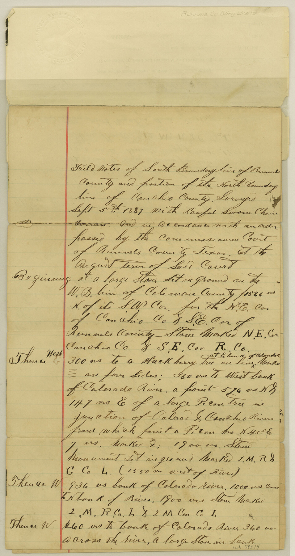
Field Notes of South Boundary line of Runnels County and portion of the North Boundary line of Conchio [sp.] County
-
Map/Doc
58514
-
Collection
General Map Collection
-
Counties
Runnels
-
Subjects
County Boundaries
-
Height x Width
15.7 x 8.3 inches
39.9 x 21.1 cm
Part of: General Map Collection
Comal County State Real Property Sketch 1

Print $134.00
- Digital $50.00
Comal County State Real Property Sketch 1
2006
Size 23.8 x 35.4 inches
Map/Doc 88635

[Map Showing Parmer, Castro, Bailey, Lamb, Cochran & Hockley Counties, Texas]
![1762, [Map Showing Parmer, Castro, Bailey, Lamb, Cochran & Hockley Counties, Texas], General Map Collection](https://historictexasmaps.com/wmedia_w700/maps/1762.tif.jpg)
Print $40.00
- Digital $50.00
[Map Showing Parmer, Castro, Bailey, Lamb, Cochran & Hockley Counties, Texas]
1910
Size 55.3 x 40.1 inches
Map/Doc 1762
Flight Mission No. BRE-1P, Frame 29, Nueces County

Print $20.00
- Digital $50.00
Flight Mission No. BRE-1P, Frame 29, Nueces County
1956
Size 18.4 x 22.5 inches
Map/Doc 86625
Harris County Historic Topographic 28

Print $20.00
- Digital $50.00
Harris County Historic Topographic 28
1915
Size 29.5 x 22.8 inches
Map/Doc 65839
Lamb County Sketch File 10

Print $22.00
- Digital $50.00
Lamb County Sketch File 10
1912
Size 20.0 x 31.2 inches
Map/Doc 11972
Hale County Boundary File 5

Print $4.00
- Digital $50.00
Hale County Boundary File 5
Size 14.1 x 8.7 inches
Map/Doc 54071
Matagorda County Working Sketch 4

Print $20.00
- Digital $50.00
Matagorda County Working Sketch 4
1908
Size 33.1 x 32.0 inches
Map/Doc 70862
Hardin County Sketch File 35

Print $24.00
- Digital $50.00
Hardin County Sketch File 35
Size 9.2 x 8.4 inches
Map/Doc 25175
Jeff Davis County Sketch File 4

Print $42.00
- Digital $50.00
Jeff Davis County Sketch File 4
1889
Size 12.5 x 14.7 inches
Map/Doc 27893
Brewster County Working Sketch 86

Print $20.00
- Digital $50.00
Brewster County Working Sketch 86
1973
Size 27.6 x 27.7 inches
Map/Doc 67686
San Patricio County Rolled Sketch 27

Print $40.00
- Digital $50.00
San Patricio County Rolled Sketch 27
Size 49.5 x 37.8 inches
Map/Doc 9890
You may also like
Brown County Sketch File 12a

Print $8.00
- Digital $50.00
Brown County Sketch File 12a
1870
Size 12.4 x 8.1 inches
Map/Doc 16604
Coleman County Boundary File 17 (2)

Print $19.00
- Digital $50.00
Coleman County Boundary File 17 (2)
Size 5.6 x 17.4 inches
Map/Doc 51645
[Capitol League Sketch E, Hockley County]
![1765, [Capitol League Sketch E, Hockley County], General Map Collection](https://historictexasmaps.com/wmedia_w700/maps/1765.tif.jpg)
Print $20.00
- Digital $50.00
[Capitol League Sketch E, Hockley County]
1910
Size 15.8 x 19.9 inches
Map/Doc 1765
Terrell County Working Sketch 11

Print $20.00
- Digital $50.00
Terrell County Working Sketch 11
1934
Size 18.5 x 15.0 inches
Map/Doc 62160
International and Great Northern Railroad Lone Star Route and Connections

Print $20.00
- Digital $50.00
International and Great Northern Railroad Lone Star Route and Connections
1877
Size 17.3 x 23.2 inches
Map/Doc 93462
Map of Fannin County

Print $40.00
- Digital $50.00
Map of Fannin County
1841
Size 50.4 x 46.8 inches
Map/Doc 7821
Goliad County Sketch File 41

Print $20.00
- Digital $50.00
Goliad County Sketch File 41
1958
Size 25.2 x 35.3 inches
Map/Doc 11573
Flight Mission No. DAG-17K, Frame 136, Matagorda County

Print $20.00
- Digital $50.00
Flight Mission No. DAG-17K, Frame 136, Matagorda County
1952
Size 18.5 x 22.3 inches
Map/Doc 86353
Map of Lampasas County

Print $20.00
- Digital $50.00
Map of Lampasas County
1864
Size 20.5 x 24.8 inches
Map/Doc 3793
Map of Hamilton County

Print $20.00
- Digital $50.00
Map of Hamilton County
1916
Size 38.3 x 40.9 inches
Map/Doc 4695
General Highway Map, Waller County, Texas

Print $20.00
General Highway Map, Waller County, Texas
1961
Size 24.9 x 18.2 inches
Map/Doc 79700
