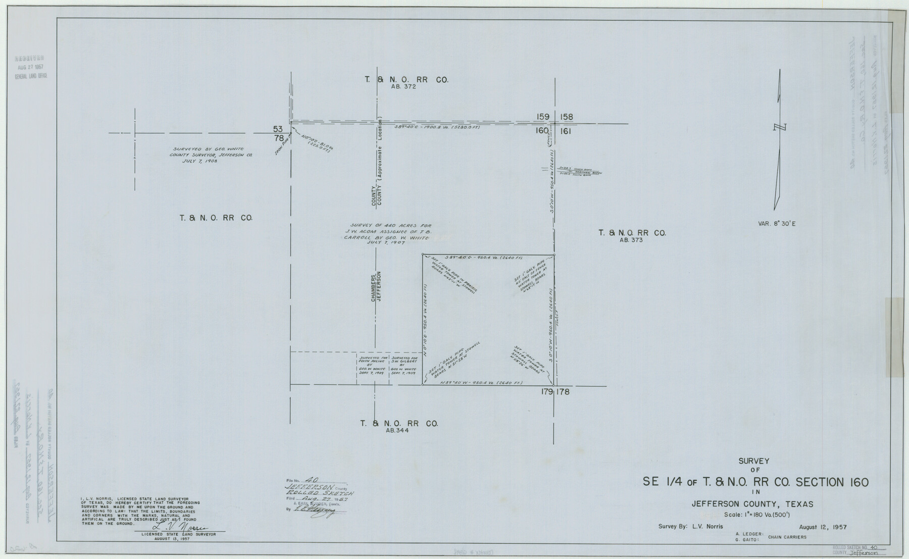
Jefferson County Rolled Sketch 40
Survey of SE 1/4 of T. & N. O. R.R. Co. section 160 in Jefferson County, Texas
-
Map/Doc
6398
-
Collection
General Map Collection
-
Object Dates
1957/8/12 (Creation Date)
1957/8/27 (File Date)
-
People and Organizations
A. Ledger (Chainman/Field Personnel)
G. Gaito (Chainman/Field Personnel)
L.V. Norris (Surveyor/Engineer)
-
Counties
Jefferson Chambers
-
Subjects
Surveying Rolled Sketch
-
Height x Width
22.6 x 36.7 inches
57.4 x 93.2 cm
-
Medium
linen, manuscript
-
Scale
1" = 180 varas
Part of: General Map Collection
Starr County Rolled Sketch X

Print $121.00
- Digital $50.00
Starr County Rolled Sketch X
Size 13.3 x 8.1 inches
Map/Doc 75961
Orange County Rolled Sketch 23

Print $20.00
- Digital $50.00
Orange County Rolled Sketch 23
1950
Size 29.0 x 35.3 inches
Map/Doc 7185
Flight Mission No. DAG-22K, Frame 75, Matagorda County

Print $20.00
- Digital $50.00
Flight Mission No. DAG-22K, Frame 75, Matagorda County
1953
Size 18.5 x 22.3 inches
Map/Doc 86462
Brooks County Working Sketch 20

Print $20.00
- Digital $50.00
Brooks County Working Sketch 20
Size 16.5 x 21.6 inches
Map/Doc 78198
Navigation Maps of Gulf Intracoastal Waterway, Port Arthur to Brownsville, Texas

Print $4.00
- Digital $50.00
Navigation Maps of Gulf Intracoastal Waterway, Port Arthur to Brownsville, Texas
1951
Size 16.7 x 21.5 inches
Map/Doc 65428
Cooke County Boundary File 20

Print $88.00
- Digital $50.00
Cooke County Boundary File 20
Size 3.2 x 8.6 inches
Map/Doc 51873
San Saba County Sketch File 15

Print $6.00
- Digital $50.00
San Saba County Sketch File 15
Size 14.2 x 8.9 inches
Map/Doc 36453
Upton County Sketch File 35

Print $14.00
- Digital $50.00
Upton County Sketch File 35
1942
Size 11.4 x 8.8 inches
Map/Doc 38886
Flight Mission No. CUG-3P, Frame 43, Kleberg County

Print $20.00
- Digital $50.00
Flight Mission No. CUG-3P, Frame 43, Kleberg County
1956
Size 18.6 x 22.3 inches
Map/Doc 86248
Intracoastal Waterway in Texas - Corpus Christi to Point Isabel including Arroyo Colorado to Mo. Pac. R.R. Bridge Near Harlingen

Print $20.00
- Digital $50.00
Intracoastal Waterway in Texas - Corpus Christi to Point Isabel including Arroyo Colorado to Mo. Pac. R.R. Bridge Near Harlingen
1934
Size 21.6 x 32.7 inches
Map/Doc 61879
Panola County Sketch File 16

Print $4.00
- Digital $50.00
Panola County Sketch File 16
1882
Size 6.4 x 8.8 inches
Map/Doc 33476
Cottle County Sketch File A1

Print $34.00
- Digital $50.00
Cottle County Sketch File A1
1882
Size 15.7 x 29.1 inches
Map/Doc 11199
You may also like
Swisher County

Print $20.00
- Digital $50.00
Swisher County
1879
Size 21.1 x 18.4 inches
Map/Doc 4064

Live Oak County Sketch File 4

Print $20.00
- Digital $50.00
Live Oak County Sketch File 4
1858
Size 16.3 x 19.2 inches
Map/Doc 12006
Crosby County Sketch File 5

Print $10.00
- Digital $50.00
Crosby County Sketch File 5
1887
Size 9.2 x 7.8 inches
Map/Doc 20002
Harris County Working Sketch 88

Print $20.00
- Digital $50.00
Harris County Working Sketch 88
1972
Size 30.3 x 38.4 inches
Map/Doc 65980
Flight Mission No. DCL-7C, Frame 139, Kenedy County

Print $20.00
- Digital $50.00
Flight Mission No. DCL-7C, Frame 139, Kenedy County
1943
Size 18.5 x 22.3 inches
Map/Doc 86096
Briscoe County Rolled Sketch WL

Print $20.00
- Digital $50.00
Briscoe County Rolled Sketch WL
1936
Size 18.6 x 43.0 inches
Map/Doc 5335

Crockett County Rolled Sketch 57

Print $40.00
- Digital $50.00
Crockett County Rolled Sketch 57
1944
Size 52.7 x 28.0 inches
Map/Doc 8719
Jeff Davis County Working Sketch 11

Print $20.00
- Digital $50.00
Jeff Davis County Working Sketch 11
1947
Size 23.3 x 43.1 inches
Map/Doc 66506
A Map of Mexico, Louisiana and the Missouri Territory, including also the State of Mississippi, Alabama Territory, East & West Florida, Georgia, South Carolina & part of the Island of Cuba

Print $40.00
A Map of Mexico, Louisiana and the Missouri Territory, including also the State of Mississippi, Alabama Territory, East & West Florida, Georgia, South Carolina & part of the Island of Cuba
Size 66.9 x 64.2 inches
Map/Doc 95312
Flight Mission No. BRA-7M, Frame 206, Jefferson County

Print $20.00
- Digital $50.00
Flight Mission No. BRA-7M, Frame 206, Jefferson County
1953
Size 18.6 x 22.2 inches
Map/Doc 85574