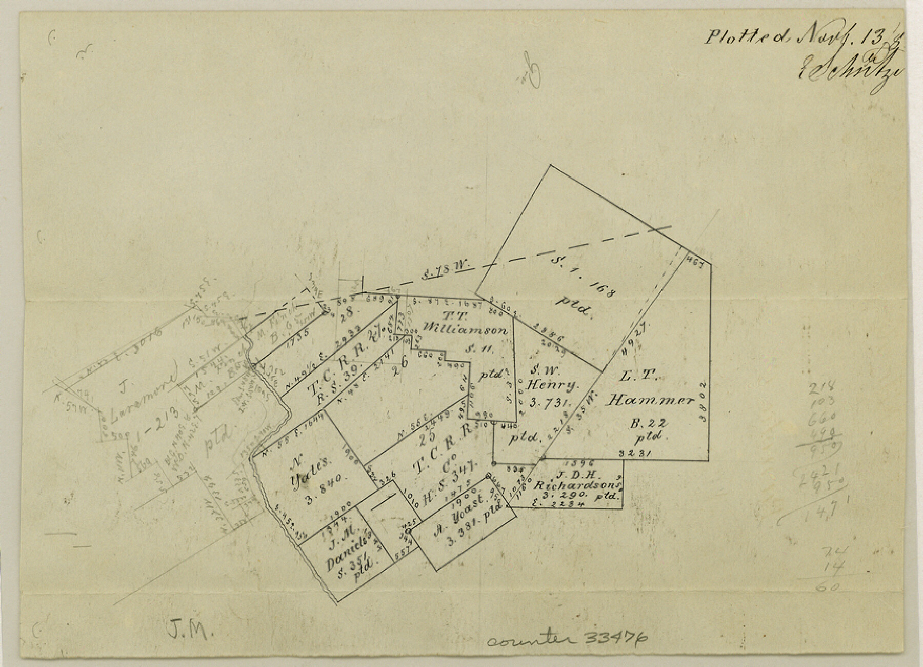
Panola County Sketch File 16
[Sketch in the northeast part of the county]
-
Map/Doc
33476
-
Collection
General Map Collection
-
Object Dates
11/13/1882 (Creation Date)
11/13/1882 (File Date)
-
People and Organizations
E. Schutze (Draftsman)
-
Counties
Panola Harrison
-
Subjects
Surveying Sketch File
-
Height x Width
6.4 x 8.8 inches
16.3 x 22.4 cm
-
Medium
paper, manuscript
Part of: General Map Collection
Rusk County Working Sketch 29a

Print $20.00
- Digital $50.00
Rusk County Working Sketch 29a
1933
Size 18.1 x 25.8 inches
Map/Doc 63665
Menard County Working Sketch 21

Print $20.00
- Digital $50.00
Menard County Working Sketch 21
1948
Size 32.1 x 41.7 inches
Map/Doc 70968
Chart of the West Indies and Spanish Dominions in North America

Print $20.00
- Digital $50.00
Chart of the West Indies and Spanish Dominions in North America
1803
Size 25.6 x 39.2 inches
Map/Doc 97138
Bandera County Working Sketch 16b

Print $20.00
- Digital $50.00
Bandera County Working Sketch 16b
1941
Size 18.9 x 23.1 inches
Map/Doc 67610

Medina County Sketch File 17

Print $40.00
- Digital $50.00
Medina County Sketch File 17
1949
Size 13.1 x 13.3 inches
Map/Doc 31480
Map of Jack County

Print $20.00
- Digital $50.00
Map of Jack County
Size 18.4 x 15.9 inches
Map/Doc 3702
Reagan County Sketch File RB

Print $8.00
- Digital $50.00
Reagan County Sketch File RB
Size 11.3 x 9.0 inches
Map/Doc 34996
Fannin County Sketch File 20b

Print $4.00
- Digital $50.00
Fannin County Sketch File 20b
1890
Size 14.2 x 8.9 inches
Map/Doc 22485
[Surveys in Austin's Colony along the east bank of the Navidad River]
![211, [Surveys in Austin's Colony along the east bank of the Navidad River], General Map Collection](https://historictexasmaps.com/wmedia_w700/maps/211.tif.jpg)
Print $20.00
- Digital $50.00
[Surveys in Austin's Colony along the east bank of the Navidad River]
1827
Size 20.2 x 16.1 inches
Map/Doc 211
Bexar County Working Sketch 23

Print $20.00
- Digital $50.00
Bexar County Working Sketch 23
1987
Size 27.7 x 34.3 inches
Map/Doc 67339
Pecos County Working Sketch 27

Print $40.00
- Digital $50.00
Pecos County Working Sketch 27
1929
Size 36.9 x 50.8 inches
Map/Doc 71498
You may also like
Bell County Sketch File 20

Print $4.00
- Digital $50.00
Bell County Sketch File 20
1855
Size 9.0 x 7.9 inches
Map/Doc 14406
El Paso County Boundary File 13

Print $37.00
- Digital $50.00
El Paso County Boundary File 13
Size 11.1 x 8.6 inches
Map/Doc 53161
Gaines County

Print $40.00
- Digital $50.00
Gaines County
1956
Size 45.1 x 56.6 inches
Map/Doc 95504
Floyd County Boundary File 2

Print $53.00
- Digital $50.00
Floyd County Boundary File 2
Size 8.9 x 4.2 inches
Map/Doc 53462
Travis County Working Sketch 63

Print $20.00
- Digital $50.00
Travis County Working Sketch 63
1998
Size 24.0 x 29.5 inches
Map/Doc 69447
Childress County Sketch File 21

Print $10.00
- Digital $50.00
Childress County Sketch File 21
1896
Size 9.1 x 5.8 inches
Map/Doc 18298
Flight Mission No. CRC-2R, Frame 114, Chambers County

Print $20.00
- Digital $50.00
Flight Mission No. CRC-2R, Frame 114, Chambers County
1956
Size 18.5 x 22.4 inches
Map/Doc 84741
McCulloch County Working Sketch 13

Print $20.00
- Digital $50.00
McCulloch County Working Sketch 13
1989
Size 36.7 x 33.3 inches
Map/Doc 70688
Working Sketch Compiled from Original Field Notes Irion County, Texas

Print $20.00
- Digital $50.00
Working Sketch Compiled from Original Field Notes Irion County, Texas
Size 19.4 x 19.5 inches
Map/Doc 92187
Rockwall County Sketch File 1

Print $22.00
Rockwall County Sketch File 1
Size 14.5 x 16.1 inches
Map/Doc 35413
Angelina County Working Sketch 3

Print $20.00
- Digital $50.00
Angelina County Working Sketch 3
1894
Size 17.9 x 16.6 inches
Map/Doc 67083
Robertson County Working Sketch 21

Print $20.00
- Digital $50.00
Robertson County Working Sketch 21
2006
Size 44.0 x 33.1 inches
Map/Doc 84701