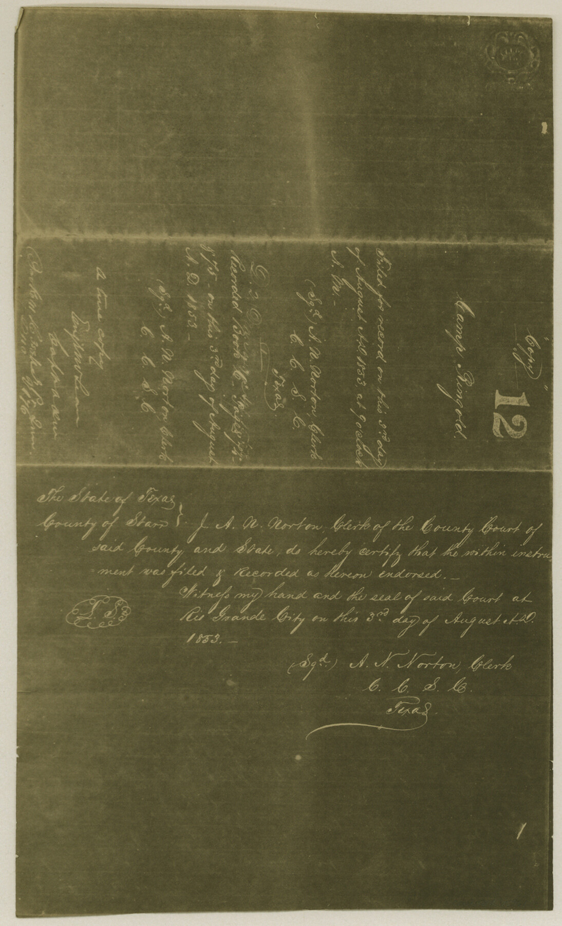
Starr County Rolled Sketch X
[Sketches and field notes relating to Fort Ringgold, Starr County, Texas]
-
Map/Doc
75961
-
Collection
General Map Collection
-
Counties
Starr
-
Subjects
Surveying Rolled Sketch
-
Height x Width
13.3 x 8.1 inches
33.8 x 20.6 cm
-
Medium
multi-page, multi-format
Part of: General Map Collection
Jeff Davis County Working Sketch 23

Print $20.00
- Digital $50.00
Jeff Davis County Working Sketch 23
1958
Size 41.5 x 30.7 inches
Map/Doc 66518
Presidio County Sketch File 105

Print $40.00
- Digital $50.00
Presidio County Sketch File 105
Size 15.6 x 59.1 inches
Map/Doc 82963

Polk County Working Sketch 33b

Print $20.00
- Digital $50.00
Polk County Working Sketch 33b
1960
Size 14.9 x 24.8 inches
Map/Doc 71650
Current Miscellaneous File 58

Print $8.00
- Digital $50.00
Current Miscellaneous File 58
1955
Size 11.6 x 9.2 inches
Map/Doc 74052
Panola County Working Sketch 23

Print $20.00
- Digital $50.00
Panola County Working Sketch 23
1951
Map/Doc 71432
[F. W. & D. C. Ry. Co. Alignment and Right of Way Map, Clay County]
![64728, [F. W. & D. C. Ry. Co. Alignment and Right of Way Map, Clay County], General Map Collection](https://historictexasmaps.com/wmedia_w700/maps/64728-1.tif.jpg)
Print $20.00
- Digital $50.00
[F. W. & D. C. Ry. Co. Alignment and Right of Way Map, Clay County]
1927
Size 18.8 x 11.7 inches
Map/Doc 64728
Outer Continental Shelf Leasing Maps (Texas Offshore Operations)

Print $20.00
- Digital $50.00
Outer Continental Shelf Leasing Maps (Texas Offshore Operations)
Size 17.7 x 14.1 inches
Map/Doc 75855
Flight Mission No. BRE-1P, Frame 94, Nueces County

Print $20.00
- Digital $50.00
Flight Mission No. BRE-1P, Frame 94, Nueces County
1956
Size 18.6 x 22.4 inches
Map/Doc 86665
Flight Mission No. DQN-2K, Frame 91, Calhoun County

Print $20.00
- Digital $50.00
Flight Mission No. DQN-2K, Frame 91, Calhoun County
1953
Size 18.8 x 22.4 inches
Map/Doc 84281
Harrison County Sketch File 22

Print $20.00
- Digital $50.00
Harrison County Sketch File 22
1917
Size 24.6 x 23.4 inches
Map/Doc 11695
Freestone County Boundary File 30d

Print $20.00
- Digital $50.00
Freestone County Boundary File 30d
Size 8.0 x 29.6 inches
Map/Doc 53608
You may also like
Schleicher County Sketch File 27

Print $20.00
- Digital $50.00
Schleicher County Sketch File 27
Size 23.0 x 19.2 inches
Map/Doc 12305
Runnels County Sketch File 37

Print $20.00
Runnels County Sketch File 37
1889
Size 24.9 x 21.3 inches
Map/Doc 12268
Williamson County

Print $40.00
- Digital $50.00
Williamson County
1888
Size 39.7 x 56.3 inches
Map/Doc 63129
Map Showing Lands Surveyed by Sylvan Sanders in Block D, Yoakum County, Texas

Print $20.00
- Digital $50.00
Map Showing Lands Surveyed by Sylvan Sanders in Block D, Yoakum County, Texas
Size 28.6 x 24.4 inches
Map/Doc 92008
Flight Mission No. BRE-1P, Frame 50, Nueces County

Print $20.00
- Digital $50.00
Flight Mission No. BRE-1P, Frame 50, Nueces County
1956
Size 18.5 x 22.3 inches
Map/Doc 86639
Right of Way and Track Map, International & Gt. Northern Ry. operated by the International & Gt. Northern Ry. Co. Gulf Division, Mineola Branch

Print $40.00
- Digital $50.00
Right of Way and Track Map, International & Gt. Northern Ry. operated by the International & Gt. Northern Ry. Co. Gulf Division, Mineola Branch
1917
Size 25.2 x 120.8 inches
Map/Doc 64703
Travis County Rolled Sketch 47

Print $40.00
- Digital $50.00
Travis County Rolled Sketch 47
1925
Size 24.9 x 56.8 inches
Map/Doc 10016
[Val Verde County]
![63095, [Val Verde County], General Map Collection](https://historictexasmaps.com/wmedia_w700/maps/63095.tif.jpg)
Print $20.00
- Digital $50.00
[Val Verde County]
1898
Size 39.1 x 32.4 inches
Map/Doc 63095
Presidio County Rolled Sketch 82

Print $20.00
- Digital $50.00
Presidio County Rolled Sketch 82
1943
Size 35.5 x 26.1 inches
Map/Doc 7369

Angelina County Working Sketch 34

Print $20.00
- Digital $50.00
Angelina County Working Sketch 34
1956
Size 30.2 x 22.9 inches
Map/Doc 67117
General Highway Map, Oldham County, Deaf Smith County, Texas

Print $20.00
General Highway Map, Oldham County, Deaf Smith County, Texas
1940
Size 18.3 x 25.2 inches
Map/Doc 79072