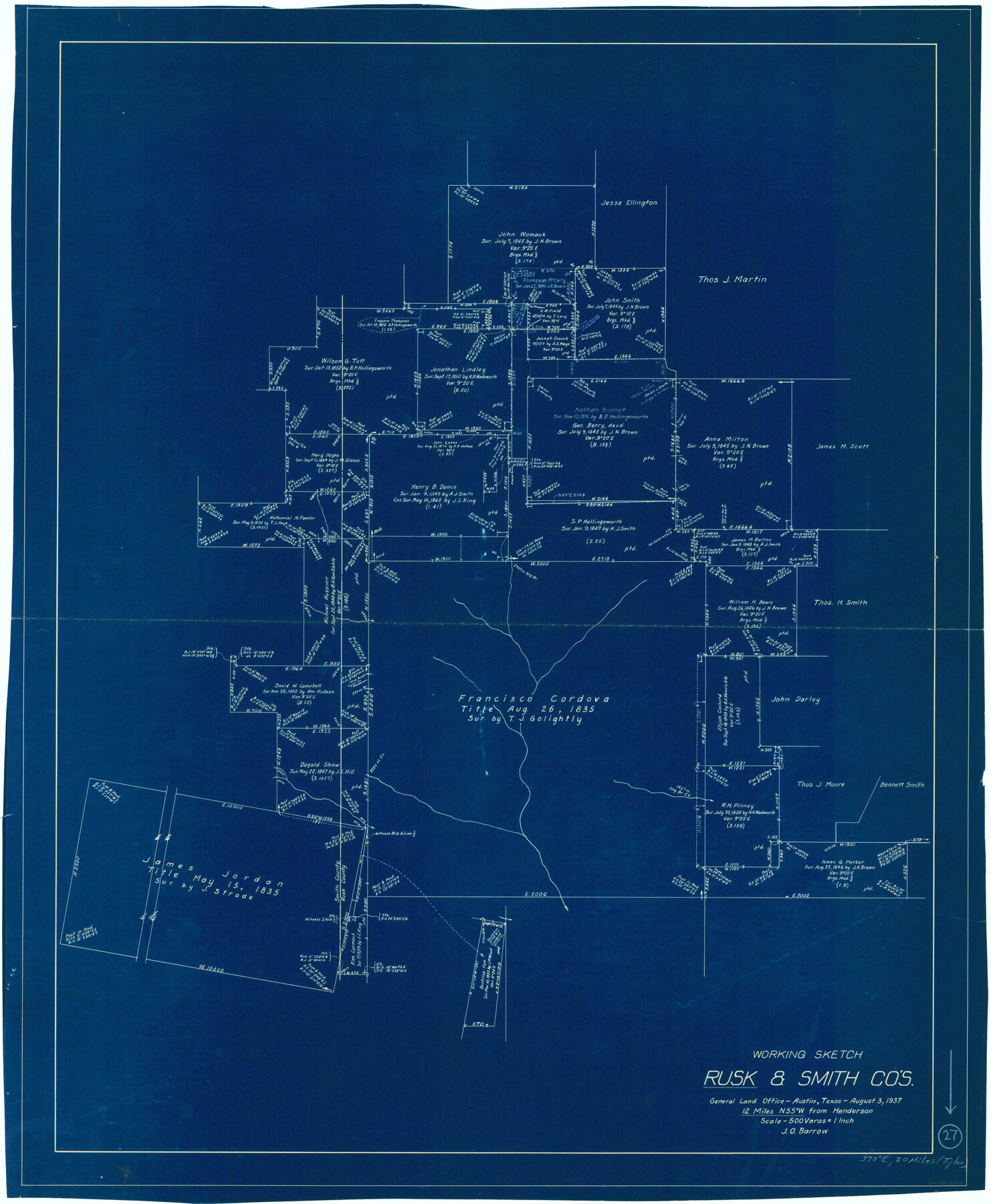
Rusk County Working Sketch 27
-
Map/Doc
63663
-
Collection
General Map Collection
-
Object Dates
8/3/1937 (Creation Date)
-
People and Organizations
J.O. Barrow (Draftsman)
-
Counties
Rusk Smith
-
Subjects
Surveying Working Sketch
-
Height x Width
35.6 x 29.3 inches
90.4 x 74.4 cm
-
Scale
1" = 500 varas
Part of: General Map Collection
Coleman County Sketch File 7

Print $2.00
- Digital $50.00
Coleman County Sketch File 7
Size 8.2 x 10.3 inches
Map/Doc 18674
Gregg County Sketch File 2

Print $26.00
- Digital $50.00
Gregg County Sketch File 2
1921
Size 14.2 x 8.7 inches
Map/Doc 24553
Sutton County Working Sketch 55

Print $20.00
- Digital $50.00
Sutton County Working Sketch 55
1957
Size 42.2 x 28.7 inches
Map/Doc 62398
Polk County Sketch File 17

Print $4.00
- Digital $50.00
Polk County Sketch File 17
1861
Size 8.1 x 9.5 inches
Map/Doc 34163
Presidio County Sketch File 121

Print $57.00
- Digital $50.00
Presidio County Sketch File 121
1998
Size 11.0 x 8.5 inches
Map/Doc 82620
[Surveys along the Trinity River]
![330, [Surveys along the Trinity River], General Map Collection](https://historictexasmaps.com/wmedia_w700/maps/330.tif.jpg)
Print $2.00
- Digital $50.00
[Surveys along the Trinity River]
1846
Size 9.0 x 12.2 inches
Map/Doc 330
Hunt County Boundary File 5

Print $6.00
- Digital $50.00
Hunt County Boundary File 5
Size 11.2 x 8.9 inches
Map/Doc 55222
Matagorda County Working Sketch 1

Print $20.00
- Digital $50.00
Matagorda County Working Sketch 1
Size 24.1 x 17.1 inches
Map/Doc 70859
Marion County Working Sketch 30

Print $20.00
- Digital $50.00
Marion County Working Sketch 30
1979
Size 31.7 x 38.3 inches
Map/Doc 70806
Freestone County Rolled Sketch 12A

Print $40.00
- Digital $50.00
Freestone County Rolled Sketch 12A
1987
Size 35.2 x 48.6 inches
Map/Doc 8897
Pecos County Rolled Sketch 51

Print $20.00
- Digital $50.00
Pecos County Rolled Sketch 51
1914
Size 8.6 x 35.5 inches
Map/Doc 7227
Zapata County Rolled Sketch 26

Print $20.00
- Digital $50.00
Zapata County Rolled Sketch 26
1982
Size 43.0 x 30.7 inches
Map/Doc 8319
You may also like
Pecos County Working Sketch Graphic Index - northeast part - sheet A

Print $20.00
- Digital $50.00
Pecos County Working Sketch Graphic Index - northeast part - sheet A
1975
Size 35.8 x 42.6 inches
Map/Doc 76666
Erath County Working Sketch 45

Print $20.00
- Digital $50.00
Erath County Working Sketch 45
1982
Size 25.5 x 24.8 inches
Map/Doc 69126
Kerr County Sketch File 18

Print $20.00
- Digital $50.00
Kerr County Sketch File 18
1950
Size 16.9 x 20.3 inches
Map/Doc 11921
Montgomery County Sketch File 36

Print $40.00
- Digital $50.00
Montgomery County Sketch File 36
1953
Size 51.7 x 34.9 inches
Map/Doc 10551
Atascosa County Working Sketch 20

Print $20.00
- Digital $50.00
Atascosa County Working Sketch 20
1953
Size 22.9 x 25.5 inches
Map/Doc 67216
Flight Mission No. DQN-5K, Frame 147, Calhoun County

Print $20.00
- Digital $50.00
Flight Mission No. DQN-5K, Frame 147, Calhoun County
1953
Size 18.5 x 22.1 inches
Map/Doc 84422
Uvalde County Sketch File A

Print $40.00
- Digital $50.00
Uvalde County Sketch File A
1912
Size 23.0 x 18.0 inches
Map/Doc 12537
Ownership Map of Val Verde County

Print $20.00
- Digital $50.00
Ownership Map of Val Verde County
1927
Size 32.7 x 36.9 inches
Map/Doc 92847
Sketch of the country between the Rio Bravo del Norte and the Luna Madre as high as Monterey copied from the map found among the papers of Genl. Arista

Print $20.00
- Digital $50.00
Sketch of the country between the Rio Bravo del Norte and the Luna Madre as high as Monterey copied from the map found among the papers of Genl. Arista
1846
Size 18.2 x 24.9 inches
Map/Doc 73049
[North County Line]
![90521, [North County Line], Twichell Survey Records](https://historictexasmaps.com/wmedia_w700/maps/90521-1.tif.jpg)
Print $3.00
- Digital $50.00
[North County Line]
Size 17.3 x 6.6 inches
Map/Doc 90521
[J. Sherwood and surrounding surveys]
![90977, [J. Sherwood and surrounding surveys], Twichell Survey Records](https://historictexasmaps.com/wmedia_w700/maps/90977-1.tif.jpg)
Print $20.00
- Digital $50.00
[J. Sherwood and surrounding surveys]
Size 24.2 x 18.1 inches
Map/Doc 90977
Harris County Sketch File 20a

Print $4.00
- Digital $50.00
Harris County Sketch File 20a
Size 8.8 x 14.4 inches
Map/Doc 25371