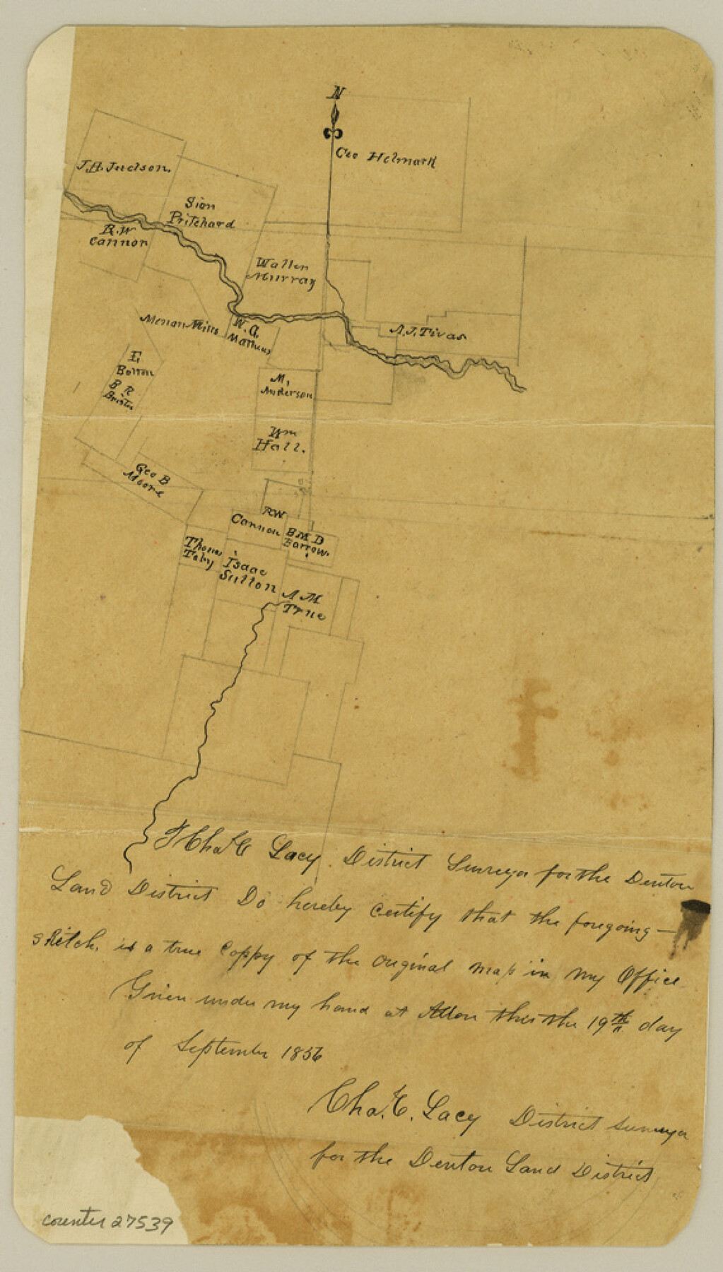
Jack County Sketch File 14
[Four sketches]
-
Map/Doc
27539
-
Collection
General Map Collection
-
Object Dates
1857/10/14 (Creation Date)
1856/9/19 (Creation Date)
-
People and Organizations
Pressler (Surveyor/Engineer)
Chaes H. Lacy (Surveyor/Engineer)
-
Counties
Jack
-
Subjects
Surveying Sketch File
-
Height x Width
10.0 x 5.7 inches
25.4 x 14.5 cm
-
Medium
paper, manuscript
-
Scale
1:4000
-
Features
Trinity River
Mesquiteville
West Fork [of Trinity River]
Part of: General Map Collection
Map of Hopkins Co.

Print $20.00
- Digital $50.00
Map of Hopkins Co.
1885
Size 36.6 x 38.7 inches
Map/Doc 4982
Dimmit County Boundary File 6

Print $32.00
- Digital $50.00
Dimmit County Boundary File 6
Size 31.1 x 7.0 inches
Map/Doc 52580
Maverick County Sketch File 13a

Print $6.00
- Digital $50.00
Maverick County Sketch File 13a
1883
Size 14.1 x 8.8 inches
Map/Doc 31108
Brown County Rolled Sketch 2

Print $20.00
- Digital $50.00
Brown County Rolled Sketch 2
1984
Size 42.4 x 25.2 inches
Map/Doc 5349
Morris County Rolled Sketch 2A

Print $64.00
- Digital $50.00
Morris County Rolled Sketch 2A
1944
Size 11.2 x 8.8 inches
Map/Doc 41667
Liberty County Rolled Sketch H

Print $20.00
- Digital $50.00
Liberty County Rolled Sketch H
1943
Size 22.2 x 29.6 inches
Map/Doc 6623
Comal County Sketch File 9 1/2

Print $6.00
- Digital $50.00
Comal County Sketch File 9 1/2
Size 12.9 x 8.4 inches
Map/Doc 19018
Atascosa County Boundary File 5

Print $32.00
- Digital $50.00
Atascosa County Boundary File 5
Size 8.8 x 6.3 inches
Map/Doc 50198
Palo Pinto County

Print $20.00
- Digital $50.00
Palo Pinto County
1879
Size 24.8 x 18.4 inches
Map/Doc 3934
Ellis County Sketch File 20

Print $19.00
- Digital $50.00
Ellis County Sketch File 20
1869
Size 12.8 x 8.2 inches
Map/Doc 21869
Cameron County NRC Article 33.136 Location Key Sheet

Print $20.00
- Digital $50.00
Cameron County NRC Article 33.136 Location Key Sheet
1983
Size 27.0 x 22.0 inches
Map/Doc 77013
Zapata County Working Sketch 5

Print $20.00
- Digital $50.00
Zapata County Working Sketch 5
1940
Size 23.4 x 18.3 inches
Map/Doc 62056
You may also like
[Sketch showing the area around the state line in Roberts and Clay Counties, along the north bank of the Canadian River]
![91762, [Sketch showing the area around the state line in Roberts and Clay Counties, along the north bank of the Canadian River], Twichell Survey Records](https://historictexasmaps.com/wmedia_w700/maps/91762-1.tif.jpg)
Print $20.00
- Digital $50.00
[Sketch showing the area around the state line in Roberts and Clay Counties, along the north bank of the Canadian River]
1901
Size 14.3 x 12.7 inches
Map/Doc 91762
Henderson County

Print $40.00
- Digital $50.00
Henderson County
1988
Size 35.3 x 69.7 inches
Map/Doc 95528
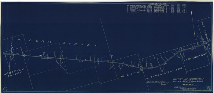
Right-of-Way and Track Map, Texas State Railroad operated by the T. and N.O. R.R. Co.
Print $40.00
- Digital $50.00
Right-of-Way and Track Map, Texas State Railroad operated by the T. and N.O. R.R. Co.
1917
Size 24.7 x 56.0 inches
Map/Doc 64172
Henderson County Rolled Sketch 11

Print $20.00
- Digital $50.00
Henderson County Rolled Sketch 11
1915
Size 29.4 x 42.2 inches
Map/Doc 75949
Travis County State Real Property Sketch 3

Print $20.00
- Digital $50.00
Travis County State Real Property Sketch 3
1985
Size 34.3 x 35.9 inches
Map/Doc 61694
Mitchell County Working Sketch 4, draft

Print $40.00
- Digital $50.00
Mitchell County Working Sketch 4, draft
Size 25.7 x 59.5 inches
Map/Doc 78202
Trinity County Rolled Sketch 5

Print $20.00
- Digital $50.00
Trinity County Rolled Sketch 5
1993
Size 25.3 x 38.0 inches
Map/Doc 8052
Rains County Working Sketch 2

Print $20.00
- Digital $50.00
Rains County Working Sketch 2
Size 14.0 x 12.2 inches
Map/Doc 71828
Henderson County Working Sketch 14

Print $20.00
- Digital $50.00
Henderson County Working Sketch 14
1934
Size 26.2 x 22.9 inches
Map/Doc 66147
Webb County Sketch File 67

Print $20.00
- Digital $50.00
Webb County Sketch File 67
1953
Size 32.8 x 46.1 inches
Map/Doc 10430
Parker County Rolled Sketch 3

Print $20.00
- Digital $50.00
Parker County Rolled Sketch 3
1975
Size 22.7 x 18.3 inches
Map/Doc 7204
General Highway Map, Palo Pinto County, Texas

Print $20.00
General Highway Map, Palo Pinto County, Texas
1940
Size 18.2 x 24.6 inches
Map/Doc 79213