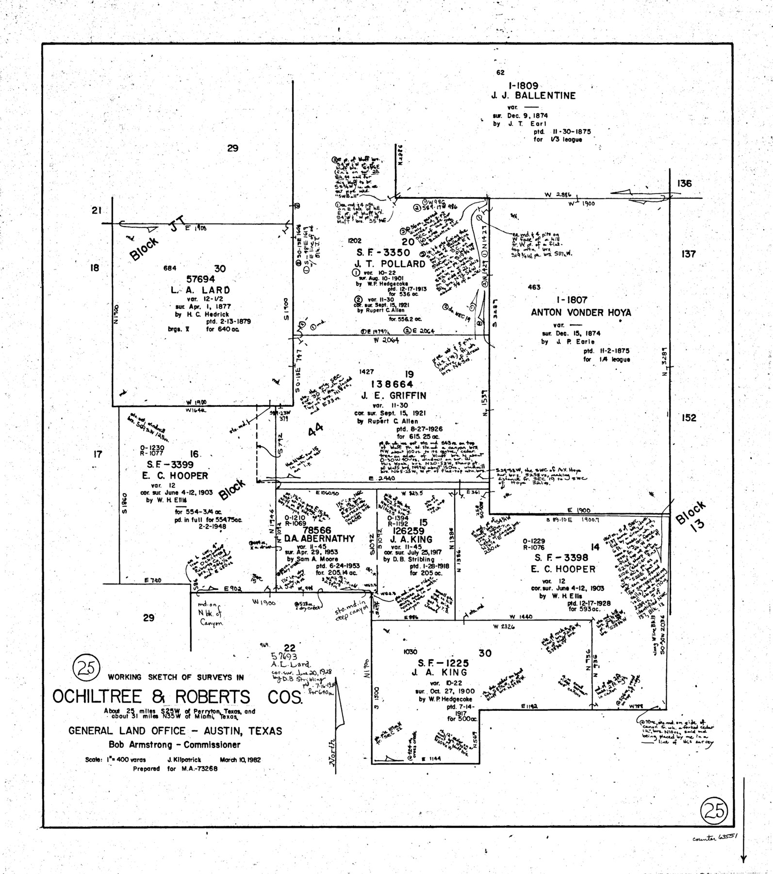
Roberts County Working Sketch 25
-
Map/Doc
63551
-
Collection
General Map Collection
-
Object Dates
3/10/1982 (Creation Date)
-
People and Organizations
Joan Kilpatrick (Draftsman)
-
Counties
Roberts Ochiltree
-
Subjects
Surveying Working Sketch
-
Height x Width
23.0 x 20.4 inches
58.4 x 51.8 cm
-
Scale
1" = 400 varas
Part of: General Map Collection
Map of Galveston County

Print $20.00
- Digital $50.00
Map of Galveston County
1864
Size 19.6 x 28.0 inches
Map/Doc 3576
Polk County Working Sketch 18

Print $20.00
- Digital $50.00
Polk County Working Sketch 18
1949
Size 25.4 x 23.3 inches
Map/Doc 71633
Flight Mission No. BRA-3M, Frame 200, Jefferson County

Print $20.00
- Digital $50.00
Flight Mission No. BRA-3M, Frame 200, Jefferson County
1953
Size 18.5 x 22.4 inches
Map/Doc 85415
Jeff Davis County Sketch File 43

Print $10.00
- Digital $50.00
Jeff Davis County Sketch File 43
1970
Size 14.2 x 8.6 inches
Map/Doc 28066
[Surveys in the Bexar District in the vicinity of Salado and Saltillo Creeks]
![234, [Surveys in the Bexar District in the vicinity of Salado and Saltillo Creeks], General Map Collection](https://historictexasmaps.com/wmedia_w700/maps/234.tif.jpg)
Print $2.00
- Digital $50.00
[Surveys in the Bexar District in the vicinity of Salado and Saltillo Creeks]
1847
Size 10.3 x 9.1 inches
Map/Doc 234
Coleman County Sketch File 25

Print $40.00
- Digital $50.00
Coleman County Sketch File 25
1872
Size 12.5 x 15.8 inches
Map/Doc 18710
Ward County Working Sketch 31

Print $40.00
- Digital $50.00
Ward County Working Sketch 31
1967
Size 32.0 x 75.6 inches
Map/Doc 72337
Flight Mission No. DQN-6K, Frame 17, Calhoun County

Print $20.00
- Digital $50.00
Flight Mission No. DQN-6K, Frame 17, Calhoun County
1953
Size 18.5 x 22.1 inches
Map/Doc 84439
Map of Refugio District

Print $20.00
- Digital $50.00
Map of Refugio District
1850
Size 22.6 x 25.1 inches
Map/Doc 1959
[East Line & Red River Railroad from Sulphur Springs to Jefferson]
![64768, [East Line & Red River Railroad from Sulphur Springs to Jefferson], General Map Collection](https://historictexasmaps.com/wmedia_w700/maps/64768.tif.jpg)
Print $40.00
- Digital $50.00
[East Line & Red River Railroad from Sulphur Springs to Jefferson]
1879
Size 38.0 x 108.5 inches
Map/Doc 64768
Live Oak County Working Sketch 37

Print $40.00
- Digital $50.00
Live Oak County Working Sketch 37
2012
Size 34.4 x 48.7 inches
Map/Doc 93363
Refugio County Sketch File 7

Print $4.00
- Digital $50.00
Refugio County Sketch File 7
1875
Size 12.1 x 7.6 inches
Map/Doc 35251
You may also like
Current Miscellaneous File 36

Print $12.00
- Digital $50.00
Current Miscellaneous File 36
Size 10.3 x 12.4 inches
Map/Doc 73952
Glasscock County

Print $20.00
- Digital $50.00
Glasscock County
1899
Size 44.2 x 35.5 inches
Map/Doc 4957
Stephens County Working Sketch 12

Print $20.00
- Digital $50.00
Stephens County Working Sketch 12
1947
Size 20.9 x 22.2 inches
Map/Doc 63955
Map of the City of Galveston, Texas

Print $40.00
- Digital $50.00
Map of the City of Galveston, Texas
1883
Size 37.2 x 66.3 inches
Map/Doc 96981
La Salle County Sketch File A

Print $30.00
- Digital $50.00
La Salle County Sketch File A
1880
Size 8.1 x 12.5 inches
Map/Doc 29532

Flight Mission No. DIX-8P, Frame 88, Aransas County

Print $20.00
- Digital $50.00
Flight Mission No. DIX-8P, Frame 88, Aransas County
1956
Size 18.6 x 22.3 inches
Map/Doc 83913

Val Verde County Rolled Sketch 33

Print $20.00
- Digital $50.00
Val Verde County Rolled Sketch 33
1891
Size 27.8 x 28.2 inches
Map/Doc 8112
Tom Green County Sketch File 69

Print $40.00
- Digital $50.00
Tom Green County Sketch File 69
1945
Size 16.5 x 12.4 inches
Map/Doc 38239
Somervell County

Print $20.00
- Digital $50.00
Somervell County
1941
Size 28.1 x 26.1 inches
Map/Doc 73291
Flight Mission No. BRE-1P, Frame 27, Nueces County

Print $20.00
- Digital $50.00
Flight Mission No. BRE-1P, Frame 27, Nueces County
1956
Size 18.5 x 22.4 inches
Map/Doc 86622