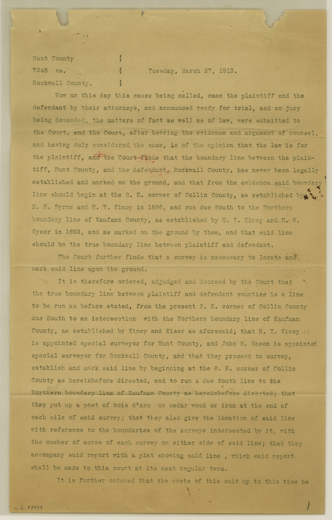
Rockwall County Boundary File 10
-
Map/Doc
58439
-
Collection
General Map Collection
-
Counties
Rockwall
-
Subjects
County Boundaries
-
Height x Width
14.0 x 8.9 inches
35.6 x 22.6 cm
Part of: General Map Collection
McLennan County Working Sketch 6

Print $20.00
- Digital $50.00
McLennan County Working Sketch 6
1957
Size 26.7 x 24.8 inches
Map/Doc 70699
Zavala County Sketch File 10a

Print $6.00
- Digital $50.00
Zavala County Sketch File 10a
1885
Size 14.6 x 8.8 inches
Map/Doc 41267
Menard County Working Sketch 10

Print $20.00
- Digital $50.00
Menard County Working Sketch 10
1938
Size 21.8 x 18.5 inches
Map/Doc 70957
Flight Mission No. CON-2R, Frame 94, Stonewall County

Print $20.00
- Digital $50.00
Flight Mission No. CON-2R, Frame 94, Stonewall County
1957
Size 18.5 x 22.2 inches
Map/Doc 86988
Cass County Working Sketch 34

Print $20.00
- Digital $50.00
Cass County Working Sketch 34
1982
Size 21.1 x 24.6 inches
Map/Doc 67937
Hutchinson County Working Sketch 3

Print $20.00
- Digital $50.00
Hutchinson County Working Sketch 3
Size 18.2 x 15.8 inches
Map/Doc 66361
Liberty County Sketch File 29

Print $40.00
- Digital $50.00
Liberty County Sketch File 29
1888
Size 14.9 x 14.9 inches
Map/Doc 29955
Kimble County Working Sketch 64

Print $20.00
- Digital $50.00
Kimble County Working Sketch 64
1964
Size 15.1 x 16.9 inches
Map/Doc 70132
Pecos County Working Sketch 19

Print $20.00
- Digital $50.00
Pecos County Working Sketch 19
1917
Size 21.0 x 14.6 inches
Map/Doc 71489
Jeff Davis County Working Sketch 26

Print $20.00
- Digital $50.00
Jeff Davis County Working Sketch 26
1960
Size 22.0 x 32.6 inches
Map/Doc 66521
San Augustine County Working Sketch 12

Print $20.00
- Digital $50.00
San Augustine County Working Sketch 12
1951
Size 29.0 x 21.0 inches
Map/Doc 63700
San Jacinto County Working Sketch 19

Print $20.00
- Digital $50.00
San Jacinto County Working Sketch 19
1939
Size 25.4 x 25.2 inches
Map/Doc 63732
You may also like
Flight Mission No. CGI-4N, Frame 161, Cameron County

Print $20.00
- Digital $50.00
Flight Mission No. CGI-4N, Frame 161, Cameron County
1955
Size 18.7 x 22.4 inches
Map/Doc 84669
Cooke County Sketch File 29

Print $16.00
- Digital $50.00
Cooke County Sketch File 29
1873
Size 8.2 x 11.0 inches
Map/Doc 19283
![91316, [Loving County], Twichell Survey Records](https://historictexasmaps.com/wmedia_w700/maps/91316-1.tif.jpg)
Abandoned and Canceled Surveys - Volume 3 of 3, Counties L-Z

Abandoned and Canceled Surveys - Volume 3 of 3, Counties L-Z
Map/Doc 83250
Atascosa County Rolled Sketch 20A

Print $20.00
- Digital $50.00
Atascosa County Rolled Sketch 20A
Size 41.8 x 32.8 inches
Map/Doc 10224
Stonewall County Sketch File 4

Print $20.00
- Digital $50.00
Stonewall County Sketch File 4
Size 18.2 x 25.7 inches
Map/Doc 12363
Fort Bend County

Print $20.00
- Digital $50.00
Fort Bend County
1882
Size 21.4 x 22.7 inches
Map/Doc 3554
Right of Way & Track Map, San Antonio & Aransas Pass Railway Co.

Print $40.00
- Digital $50.00
Right of Way & Track Map, San Antonio & Aransas Pass Railway Co.
1919
Size 25.3 x 56.4 inches
Map/Doc 64217
Map of Texas Compiled from Surveys recorded in the Land Office of Texas

Print $20.00
- Digital $50.00
Map of Texas Compiled from Surveys recorded in the Land Office of Texas
1841
Size 26.4 x 22.3 inches
Map/Doc 538
Flight Mission No. BQY-4M, Frame 119, Harris County

Print $20.00
- Digital $50.00
Flight Mission No. BQY-4M, Frame 119, Harris County
1953
Size 18.7 x 22.4 inches
Map/Doc 85287
Hood County Working Sketch 10

Print $20.00
- Digital $50.00
Hood County Working Sketch 10
1974
Size 26.7 x 35.6 inches
Map/Doc 66204
Dickens County Sketch File 27

Print $25.00
- Digital $50.00
Dickens County Sketch File 27
Size 14.4 x 8.9 inches
Map/Doc 20993