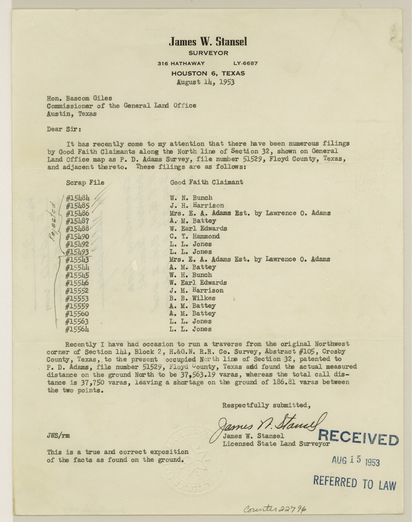
Floyd County Sketch File 33
[Connecting line between section 141, H. & G. N. Block 2 and section 32, P. D. Adams survey]
-
Map/Doc
22796
-
Collection
General Map Collection
-
Object Dates
1953/8/14 (Creation Date)
1953/8/15 (File Date)
-
People and Organizations
James W. Stansel (Surveyor/Engineer)
-
Counties
Floyd
-
Subjects
Surveying Sketch File
-
Height x Width
11.4 x 9.0 inches
29.0 x 22.9 cm
-
Medium
paper, print
Part of: General Map Collection
Flight Mission No. BRA-3M, Frame 123, Jefferson County

Print $20.00
- Digital $50.00
Flight Mission No. BRA-3M, Frame 123, Jefferson County
1953
Size 18.5 x 21.7 inches
Map/Doc 85397
Angelina County Boundary File 2

Print $20.00
- Digital $50.00
Angelina County Boundary File 2
Size 10.2 x 28.2 inches
Map/Doc 49773
Webb County Sketch File 9

Print $25.00
- Digital $50.00
Webb County Sketch File 9
1870
Size 9.5 x 8.5 inches
Map/Doc 39761
Neel's Creek of North Bosque

Print $2.00
- Digital $50.00
Neel's Creek of North Bosque
1847
Size 8.9 x 7.9 inches
Map/Doc 69755
Map of Galveston West Bay and Part of Galveston Island

Print $40.00
- Digital $50.00
Map of Galveston West Bay and Part of Galveston Island
1851
Size 31.2 x 52.6 inches
Map/Doc 69923
Flight Mission No. BRA-16M, Frame 110, Jefferson County

Print $20.00
- Digital $50.00
Flight Mission No. BRA-16M, Frame 110, Jefferson County
1953
Size 18.6 x 22.4 inches
Map/Doc 85720
Webb County Sketch File 55

Print $20.00
- Digital $50.00
Webb County Sketch File 55
1940
Size 20.6 x 12.6 inches
Map/Doc 12650
El Paso County Sketch File 42

Print $16.00
- Digital $50.00
El Paso County Sketch File 42
1996
Size 14.3 x 8.9 inches
Map/Doc 22241
Erath County Rolled Sketch 1

Print $40.00
- Digital $50.00
Erath County Rolled Sketch 1
1962
Size 37.6 x 69.0 inches
Map/Doc 8882
Wheeler County

Print $20.00
- Digital $50.00
Wheeler County
1899
Size 44.2 x 38.7 inches
Map/Doc 63121
Trinity River, Levee Improvement Districts, Widths of Floodways

Print $20.00
- Digital $50.00
Trinity River, Levee Improvement Districts, Widths of Floodways
1920
Size 31.8 x 23.2 inches
Map/Doc 65254
Map of Titus County

Print $20.00
- Digital $50.00
Map of Titus County
1879
Size 23.3 x 14.7 inches
Map/Doc 4082
You may also like
Orange County Rolled Sketch 22

Print $40.00
- Digital $50.00
Orange County Rolled Sketch 22
1950
Size 31.2 x 58.0 inches
Map/Doc 9647
Map showing the environs of Brazos Island, Texas

Print $20.00
- Digital $50.00
Map showing the environs of Brazos Island, Texas
Size 18.1 x 25.0 inches
Map/Doc 72926
Flight Mission No. CGI-2N, Frame 152, Cameron County

Print $20.00
- Digital $50.00
Flight Mission No. CGI-2N, Frame 152, Cameron County
1954
Size 18.7 x 22.1 inches
Map/Doc 84534
Intracoastal Waterway in Texas - Corpus Christi to Point Isabel including Arroyo Colorado to Mo. Pac. R.R. Bridge Near Harlingen

Print $20.00
- Digital $50.00
Intracoastal Waterway in Texas - Corpus Christi to Point Isabel including Arroyo Colorado to Mo. Pac. R.R. Bridge Near Harlingen
1933
Size 40.6 x 28.0 inches
Map/Doc 61877
Plat of South Side Addition on Section 37 Block 17, Wheeler County, Texas

Print $20.00
- Digital $50.00
Plat of South Side Addition on Section 37 Block 17, Wheeler County, Texas
Size 12.0 x 16.9 inches
Map/Doc 92103
Dimmit County Sketch File 2

Print $6.00
- Digital $50.00
Dimmit County Sketch File 2
Size 8.6 x 7.9 inches
Map/Doc 21055

Midland County Working Sketch 18

Print $40.00
- Digital $50.00
Midland County Working Sketch 18
1956
Size 26.5 x 49.5 inches
Map/Doc 70998
North Sulphur River, Ben Franklin Sheet

Print $20.00
- Digital $50.00
North Sulphur River, Ben Franklin Sheet
1928
Size 14.2 x 30.0 inches
Map/Doc 78324
Val Verde County Sketch File 21A

Print $20.00
- Digital $50.00
Val Verde County Sketch File 21A
Size 25.9 x 43.8 inches
Map/Doc 10419
University Land Loving-Ward-Winkler Counties

Print $40.00
- Digital $50.00
University Land Loving-Ward-Winkler Counties
1931
Size 47.9 x 63.2 inches
Map/Doc 2415
Current Miscellaneous File 84

Print $10.00
- Digital $50.00
Current Miscellaneous File 84
1954
Size 11.2 x 8.8 inches
Map/Doc 74231