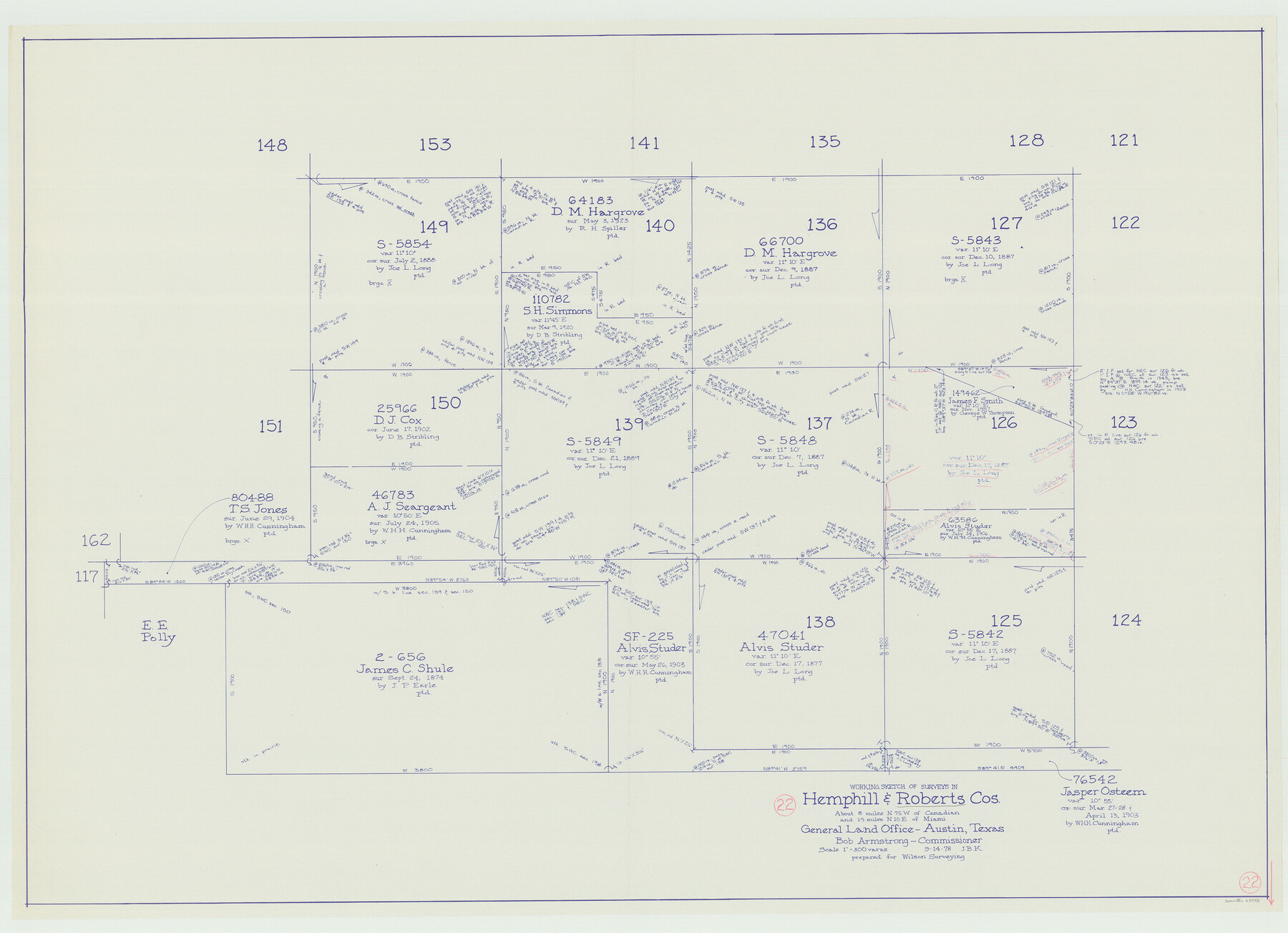
Roberts County Working Sketch 22
-
Map/Doc
63548
-
Collection
General Map Collection
-
Object Dates
9/14/1978 (Creation Date)
-
People and Organizations
Joan Kilpatrick (Draftsman)
-
Counties
Roberts Hemphill
-
Subjects
Surveying Working Sketch
-
Height x Width
31.0 x 42.9 inches
78.7 x 109.0 cm
-
Scale
1" = 300 varas
Part of: General Map Collection
Cottle County Sketch File 8

Print $20.00
- Digital $50.00
Cottle County Sketch File 8
1894
Size 37.6 x 17.6 inches
Map/Doc 11192
Grundriss von Neu-Orleans nach den manuscripten in dem schatze der karten der marine

Print $20.00
- Digital $50.00
Grundriss von Neu-Orleans nach den manuscripten in dem schatze der karten der marine
1744
Size 9.6 x 14.1 inches
Map/Doc 94109
Brewster County Working Sketch 52

Print $20.00
- Digital $50.00
Brewster County Working Sketch 52
1951
Size 28.7 x 37.3 inches
Map/Doc 67586
Flight Mission No. DCL-7C, Frame 110, Kenedy County

Print $20.00
- Digital $50.00
Flight Mission No. DCL-7C, Frame 110, Kenedy County
1943
Size 18.5 x 22.3 inches
Map/Doc 86075
Flight Mission No. CUG-3P, Frame 132, Kleberg County

Print $20.00
- Digital $50.00
Flight Mission No. CUG-3P, Frame 132, Kleberg County
1956
Size 18.4 x 22.4 inches
Map/Doc 86267
Flight Mission No. CUG-3P, Frame 190, Kleberg County

Print $20.00
- Digital $50.00
Flight Mission No. CUG-3P, Frame 190, Kleberg County
1956
Size 18.6 x 22.4 inches
Map/Doc 86294
Floyd County Boundary File 2b

Print $40.00
- Digital $50.00
Floyd County Boundary File 2b
Size 38.9 x 20.1 inches
Map/Doc 53490
Cooke County Sketch File 28

Print $4.00
- Digital $50.00
Cooke County Sketch File 28
1872
Size 12.8 x 8.5 inches
Map/Doc 19281
San Patricio County Rolled Sketch 46E

Print $20.00
- Digital $50.00
San Patricio County Rolled Sketch 46E
1983
Size 17.4 x 46.3 inches
Map/Doc 8376
Flight Mission No. DQO-2K, Frame 164, Galveston County

Print $20.00
- Digital $50.00
Flight Mission No. DQO-2K, Frame 164, Galveston County
1952
Size 18.7 x 22.3 inches
Map/Doc 85053
La Salle County Rolled Sketch 23

Print $40.00
- Digital $50.00
La Salle County Rolled Sketch 23
1956
Size 34.5 x 48.0 inches
Map/Doc 9559
Crockett County Rolled Sketch 61

Print $20.00
- Digital $50.00
Crockett County Rolled Sketch 61
Size 12.7 x 20.9 inches
Map/Doc 5604
You may also like
Coryell County Working Sketch 19

Print $20.00
- Digital $50.00
Coryell County Working Sketch 19
1970
Size 38.7 x 33.2 inches
Map/Doc 68226
Travis County Rolled Sketch 7

Print $20.00
- Digital $50.00
Travis County Rolled Sketch 7
Size 17.4 x 37.0 inches
Map/Doc 8012
Martin County Working Sketch 9

Print $20.00
- Digital $50.00
Martin County Working Sketch 9
1971
Size 45.2 x 38.1 inches
Map/Doc 70827
Map of Colorado County

Print $20.00
- Digital $50.00
Map of Colorado County
1880
Size 21.8 x 21.1 inches
Map/Doc 3426
Polk County Boundary File 2

Print $8.00
- Digital $50.00
Polk County Boundary File 2
Size 14.2 x 8.7 inches
Map/Doc 57924
Orange County Working Sketch 53

Print $20.00
- Digital $50.00
Orange County Working Sketch 53
2007
Size 34.1 x 46.0 inches
Map/Doc 87371

Map of the State of Texas

Print $20.00
- Digital $50.00
Map of the State of Texas
1881
Size 15.7 x 21.7 inches
Map/Doc 96614
Bivin's Addition to Amarillo, Texas, Survey 187, Block 2, A. B. & M., Potter County

Print $20.00
- Digital $50.00
Bivin's Addition to Amarillo, Texas, Survey 187, Block 2, A. B. & M., Potter County
Size 20.1 x 23.0 inches
Map/Doc 91739
Flight Mission No. BRA-16M, Frame 150, Jefferson County

Print $20.00
- Digital $50.00
Flight Mission No. BRA-16M, Frame 150, Jefferson County
1953
Size 18.5 x 22.3 inches
Map/Doc 85756
The Judicial District/County of Ward. Abolished, Spring 1842

Print $20.00
The Judicial District/County of Ward. Abolished, Spring 1842
2020
Size 18.7 x 21.7 inches
Map/Doc 96355
Bexar County Sketch File 54

Print $34.00
- Digital $50.00
Bexar County Sketch File 54
1793
Size 11.4 x 8.9 inches
Map/Doc 14543