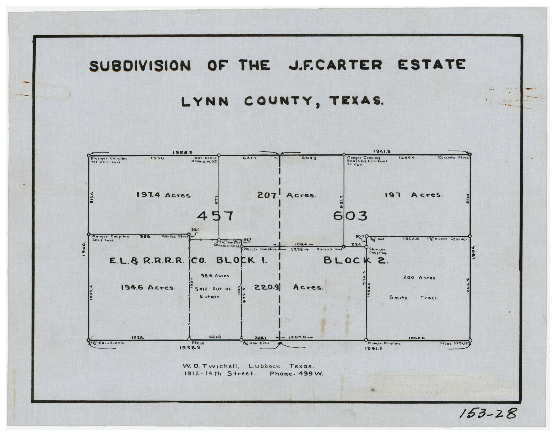
Subdivision of the J. F. Carter Estate
153-28
-
Map/Doc
91273
-
Collection
Twichell Survey Records
-
People and Organizations
W.D. Twichell (Surveyor/Engineer)
-
Counties
Lynn
-
Height x Width
11.8 x 9.6 inches
30.0 x 24.4 cm
Part of: Twichell Survey Records
Map of Capitol Syndicate Subdivisions of Capitol Reservation Lands in Parmer County, Texas

Print $20.00
- Digital $50.00
Map of Capitol Syndicate Subdivisions of Capitol Reservation Lands in Parmer County, Texas
1915
Size 17.7 x 13.2 inches
Map/Doc 91553
Map of Terry County

Print $2.00
- Digital $50.00
Map of Terry County
Size 7.6 x 8.3 inches
Map/Doc 92888
Anton Quadrangle

Print $20.00
- Digital $50.00
Anton Quadrangle
1957
Size 18.1 x 22.1 inches
Map/Doc 92814
[West Central Portion of County]
![91257, [West Central Portion of County], Twichell Survey Records](https://historictexasmaps.com/wmedia_w700/maps/91257-1.tif.jpg)
Print $20.00
- Digital $50.00
[West Central Portion of County]
Size 19.5 x 9.8 inches
Map/Doc 91257
Myrick Farms Lubbock & Hockley Counties

Print $20.00
- Digital $50.00
Myrick Farms Lubbock & Hockley Counties
Size 21.3 x 21.5 inches
Map/Doc 92830
[Pencil sketch of Wm. Rivers survey]
![91969, [Pencil sketch of Wm. Rivers survey], Twichell Survey Records](https://historictexasmaps.com/wmedia_w700/maps/91969-1.tif.jpg)
Print $3.00
- Digital $50.00
[Pencil sketch of Wm. Rivers survey]
Size 9.9 x 16.1 inches
Map/Doc 91969
Bravo Deed, Instrument 24, Tract A and Tract B

Print $3.00
- Digital $50.00
Bravo Deed, Instrument 24, Tract A and Tract B
Size 10.6 x 13.2 inches
Map/Doc 91478
[H. & T. C. Block 47, Block 1PD, and Vicinity]
![91435, [H. & T. C. Block 47, Block 1PD, and Vicinity], Twichell Survey Records](https://historictexasmaps.com/wmedia_w700/maps/91435-1.tif.jpg)
Print $20.00
- Digital $50.00
[H. & T. C. Block 47, Block 1PD, and Vicinity]
1912
Size 31.8 x 33.5 inches
Map/Doc 91435
University of Texas System University Lands

Print $20.00
- Digital $50.00
University of Texas System University Lands
Size 23.0 x 17.5 inches
Map/Doc 93240
Map of Texas-Mexican Railway Lands in El Paso County, Texas

Print $3.00
- Digital $50.00
Map of Texas-Mexican Railway Lands in El Paso County, Texas
1907
Size 13.7 x 10.8 inches
Map/Doc 91134
[J. Poitevent Blk. 1]
![90132, [J. Poitevent Blk. 1], Twichell Survey Records](https://historictexasmaps.com/wmedia_w700/maps/90132-1.tif.jpg)
Print $3.00
- Digital $50.00
[J. Poitevent Blk. 1]
Size 10.7 x 13.3 inches
Map/Doc 90132
[H. & G. N. Block 1]
![90946, [H. & G. N. Block 1], Twichell Survey Records](https://historictexasmaps.com/wmedia_w700/maps/90946-1.tif.jpg)
Print $20.00
- Digital $50.00
[H. & G. N. Block 1]
1873
Size 17.7 x 14.5 inches
Map/Doc 90946
You may also like
Jackson County Working Sketch 12

Print $20.00
- Digital $50.00
Jackson County Working Sketch 12
Size 31.2 x 33.0 inches
Map/Doc 66460
Jack County Working Sketch 13

Print $20.00
- Digital $50.00
Jack County Working Sketch 13
1975
Size 25.5 x 35.8 inches
Map/Doc 66439
Glasscock County Rolled Sketch 8

Print $20.00
- Digital $50.00
Glasscock County Rolled Sketch 8
1951
Size 38.4 x 32.3 inches
Map/Doc 9056
Liberty County Working Sketch 2

Print $20.00
- Digital $50.00
Liberty County Working Sketch 2
Size 12.4 x 22.2 inches
Map/Doc 70461
[Beaumont, Sour Lake and Western Ry. Right of Way and Alignment - Frisco]
![64123, [Beaumont, Sour Lake and Western Ry. Right of Way and Alignment - Frisco], General Map Collection](https://historictexasmaps.com/wmedia_w700/maps/64123.tif.jpg)
Print $20.00
- Digital $50.00
[Beaumont, Sour Lake and Western Ry. Right of Way and Alignment - Frisco]
1910
Size 20.4 x 46.2 inches
Map/Doc 64123
Crockett County Working Sketch 89

Print $20.00
- Digital $50.00
Crockett County Working Sketch 89
1978
Size 36.4 x 44.5 inches
Map/Doc 68422
Limestone County Sketch File 22

Print $4.00
- Digital $50.00
Limestone County Sketch File 22
Size 11.4 x 7.3 inches
Map/Doc 30201
Plan de la Villa de Austin

Print $20.00
- Digital $50.00
Plan de la Villa de Austin
1828
Size 18.5 x 12.5 inches
Map/Doc 94116
Potter County Boundary File 5a

Print $80.00
- Digital $50.00
Potter County Boundary File 5a
Size 13.0 x 71.0 inches
Map/Doc 58024
Flight Mission No. DQN-3K, Frame 32, Calhoun County

Print $20.00
- Digital $50.00
Flight Mission No. DQN-3K, Frame 32, Calhoun County
1953
Size 18.6 x 22.3 inches
Map/Doc 84345
El Paso County Sketch File 1

Print $48.00
- Digital $50.00
El Paso County Sketch File 1
1849
Size 8.9 x 8.2 inches
Map/Doc 21883
General Highway Map, Chambers County, Texas

Print $20.00
General Highway Map, Chambers County, Texas
1940
Size 18.4 x 25.3 inches
Map/Doc 79044