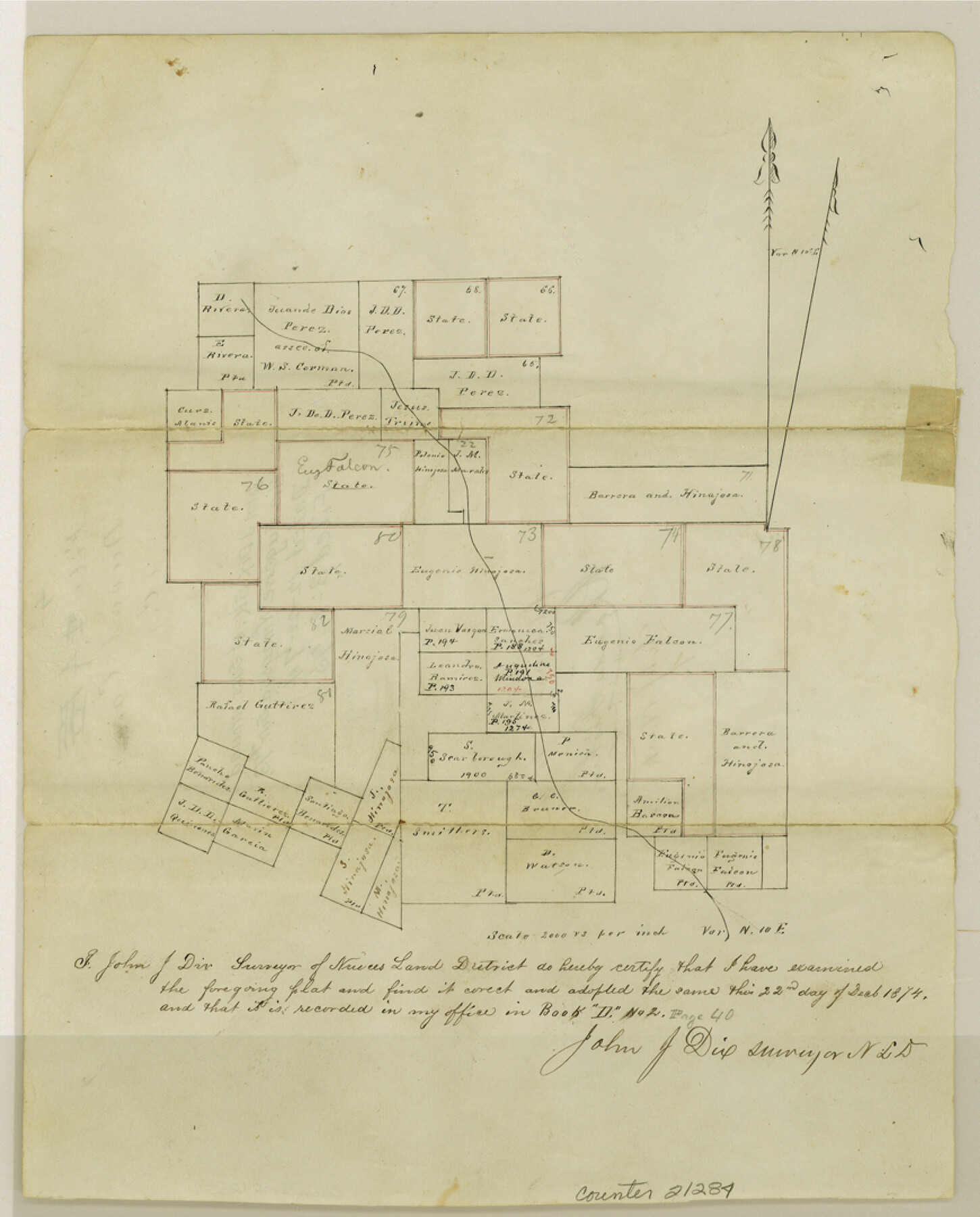
Duval County Sketch File 4c
[Sketch of surveys around the Eugene Hinojosa survey 73]
-
Map/Doc
21284
-
Collection
General Map Collection
-
Object Dates
1874/12/22 (Creation Date)
1875/3/8 (File Date)
-
People and Organizations
John J. Dix (Surveyor/Engineer)
-
Counties
Duval Jim Wells
-
Subjects
Surveying Sketch File
-
Height x Width
10.8 x 8.7 inches
27.4 x 22.1 cm
-
Medium
paper, manuscript
-
Scale
1:2000
Part of: General Map Collection
Presidio County Rolled Sketch 56

Print $20.00
- Digital $50.00
Presidio County Rolled Sketch 56
1915
Size 21.8 x 17.1 inches
Map/Doc 7349
Liberty County Working Sketch 7

Print $20.00
- Digital $50.00
Liberty County Working Sketch 7
1906
Size 22.2 x 24.8 inches
Map/Doc 70466
United States - Gulf Coast - From Latitude 26° 33' to the Rio Grande Texas

Print $20.00
- Digital $50.00
United States - Gulf Coast - From Latitude 26° 33' to the Rio Grande Texas
1919
Size 27.2 x 18.4 inches
Map/Doc 72856
Harrison County Sketch File 10

Print $4.00
- Digital $50.00
Harrison County Sketch File 10
Size 7.7 x 8.0 inches
Map/Doc 26050
Crockett County Sketch File F

Print $20.00
- Digital $50.00
Crockett County Sketch File F
1907
Size 26.3 x 15.7 inches
Map/Doc 11240
Montgomery County Rolled Sketch 22

Print $40.00
- Digital $50.00
Montgomery County Rolled Sketch 22
1934
Size 38.0 x 61.7 inches
Map/Doc 9532
Strip Map of Texas-Oklahoma Boundary from Denison East to the Oklahoma-Arkansas State Line

Print $20.00
- Digital $50.00
Strip Map of Texas-Oklahoma Boundary from Denison East to the Oklahoma-Arkansas State Line
1933
Size 37.7 x 24.5 inches
Map/Doc 75927
Webb County Working Sketch 11

Print $20.00
- Digital $50.00
Webb County Working Sketch 11
1921
Size 17.8 x 16.3 inches
Map/Doc 72376
Travis County Working Sketch 18

Print $20.00
- Digital $50.00
Travis County Working Sketch 18
1945
Size 30.4 x 42.9 inches
Map/Doc 69402
Flight Mission No. DQO-8K, Frame 52, Galveston County

Print $20.00
- Digital $50.00
Flight Mission No. DQO-8K, Frame 52, Galveston County
1952
Size 18.6 x 22.2 inches
Map/Doc 85159
Presidio County Rolled Sketch 79

Print $20.00
- Digital $50.00
Presidio County Rolled Sketch 79
Size 22.2 x 27.0 inches
Map/Doc 7365
Canada, United States of America, Estados Unidos Mexicanos

Print $20.00
- Digital $50.00
Canada, United States of America, Estados Unidos Mexicanos
Size 41.9 x 36.1 inches
Map/Doc 96512
You may also like
Briscoe County Sketch File D-2

Print $40.00
- Digital $50.00
Briscoe County Sketch File D-2
1901
Size 18.5 x 7.8 inches
Map/Doc 16411
Preliminary Chart No. 31 of the Sea Coast of the United States from Galveston Bay to Matagorda Bay, Texas

Print $20.00
Preliminary Chart No. 31 of the Sea Coast of the United States from Galveston Bay to Matagorda Bay, Texas
1857
Size 21.6 x 37.2 inches
Map/Doc 76212
[Sketch showing surveys near Brushy Creek and Old Thrall Oil Field]
![90421, [Sketch showing surveys near Brushy Creek and Old Thrall Oil Field], Twichell Survey Records](https://historictexasmaps.com/wmedia_w700/maps/90421-1.tif.jpg)
Print $20.00
- Digital $50.00
[Sketch showing surveys near Brushy Creek and Old Thrall Oil Field]
Size 27.4 x 42.6 inches
Map/Doc 90421
Carta Particular de las Costas Setentrionales del Seno Mexicano que comprehende las de la Florida Ocidental las Margenes de la Luisiana y toda la rivera que sigue por la Bahía de San Bernardo y el Río Bravo del Norte hasta la Laguna Madre

Carta Particular de las Costas Setentrionales del Seno Mexicano que comprehende las de la Florida Ocidental las Margenes de la Luisiana y toda la rivera que sigue por la Bahía de San Bernardo y el Río Bravo del Norte hasta la Laguna Madre
1825
Size 26.1 x 38.7 inches
Map/Doc 94568
Presidio County Rolled Sketch A-1

Print $20.00
- Digital $50.00
Presidio County Rolled Sketch A-1
1889
Size 26.8 x 32.0 inches
Map/Doc 9769
Bee County Sketch File 9

Print $4.00
- Digital $50.00
Bee County Sketch File 9
Size 8.1 x 10.2 inches
Map/Doc 14289
Polk County Working Sketch 11

Print $20.00
- Digital $50.00
Polk County Working Sketch 11
1940
Size 29.3 x 28.6 inches
Map/Doc 71626
McMullen County Rolled Sketch 6

Print $20.00
- Digital $50.00
McMullen County Rolled Sketch 6
Size 32.1 x 27.0 inches
Map/Doc 6724
Reclamation & Navigation Map of Trinity River Flood Plain

Print $40.00
- Digital $50.00
Reclamation & Navigation Map of Trinity River Flood Plain
1930
Size 24.3 x 75.8 inches
Map/Doc 65178
Colorado County

Print $20.00
- Digital $50.00
Colorado County
1847
Size 23.7 x 31.4 inches
Map/Doc 3424

Concho County Working Sketch 18
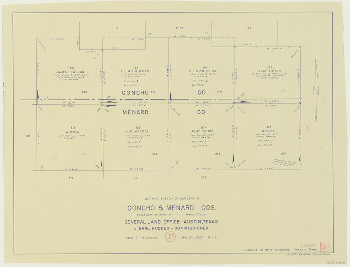
Print $20.00
- Digital $50.00
Concho County Working Sketch 18
1957
Size 19.2 x 25.2 inches
Map/Doc 68200