Stonewall County Sketch File 18-1
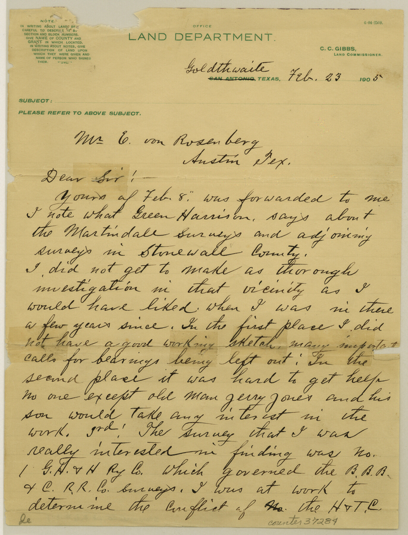
[Letter regarding the Martindale surveys and surrounding area in the northeast part of the county]
-
Map/Doc
37284
-
Collection
General Map Collection
-
Object Dates
2/23/1905 (Creation Date)
-
People and Organizations
George M. Williams (Surveyor/Engineer)
-
Counties
Stonewall
-
Subjects
Surveying Sketch File
-
Height x Width
11.3 x 8.6 inches
28.7 x 21.8 cm
-
Medium
paper, manuscript
Part of: General Map Collection
Bell County Sketch File 19

Print $4.00
- Digital $50.00
Bell County Sketch File 19
Size 7.6 x 7.7 inches
Map/Doc 14402
Nueces County NRC Article 33.136 Location Key Sheet

Print $20.00
- Digital $50.00
Nueces County NRC Article 33.136 Location Key Sheet
1975
Size 27.5 x 23.0 inches
Map/Doc 88589
Rusk County Working Sketch 26

Print $20.00
- Digital $50.00
Rusk County Working Sketch 26
1938
Size 42.8 x 36.8 inches
Map/Doc 63662
Flight Mission No. DIX-6P, Frame 194, Aransas County

Print $20.00
- Digital $50.00
Flight Mission No. DIX-6P, Frame 194, Aransas County
1956
Size 19.2 x 22.7 inches
Map/Doc 83856
Motley County Sketch File 1 (N)

Print $4.00
- Digital $50.00
Motley County Sketch File 1 (N)
Size 11.4 x 6.7 inches
Map/Doc 31994
Baylor County Rolled Sketch 9A

Print $20.00
- Digital $50.00
Baylor County Rolled Sketch 9A
1892
Size 16.0 x 24.6 inches
Map/Doc 5126
Chambers County Sketch File 31

Print $40.00
- Digital $50.00
Chambers County Sketch File 31
1856
Size 12.4 x 15.2 inches
Map/Doc 17614
Victoria County Sketch File 12

Print $4.00
- Digital $50.00
Victoria County Sketch File 12
1978
Size 11.4 x 8.9 inches
Map/Doc 39540
Pecos County Rolled Sketch 109

Print $40.00
- Digital $50.00
Pecos County Rolled Sketch 109
1940
Size 40.6 x 49.3 inches
Map/Doc 9719
Aransas County Sketch File 15b

Print $10.00
- Digital $50.00
Aransas County Sketch File 15b
1891
Size 13.8 x 8.1 inches
Map/Doc 13143
Webb County Rolled Sketch 45

Print $20.00
- Digital $50.00
Webb County Rolled Sketch 45
1942
Size 17.4 x 22.2 inches
Map/Doc 8200
Map of the Fort Worth & Denver City Railway

Print $40.00
- Digital $50.00
Map of the Fort Worth & Denver City Railway
1887
Size 22.2 x 79.5 inches
Map/Doc 64459
You may also like
Pecos County Rolled Sketch 190

Print $20.00
- Digital $50.00
Pecos County Rolled Sketch 190
2005
Size 20.3 x 26.1 inches
Map/Doc 83284
[D. & P. Blk. G6 in SE Armstrong and SW Donley Counties]
![90269, [D. & P. Blk. G6 in SE Armstrong and SW Donley Counties], Twichell Survey Records](https://historictexasmaps.com/wmedia_w700/maps/90269-1.tif.jpg)
Print $3.00
- Digital $50.00
[D. & P. Blk. G6 in SE Armstrong and SW Donley Counties]
Size 11.7 x 9.4 inches
Map/Doc 90269
A Geological Map of the United States and Canada

Print $20.00
A Geological Map of the United States and Canada
1853
Size 17.4 x 25.0 inches
Map/Doc 95189
[Lynn and Adjacent Counties]
![92961, [Lynn and Adjacent Counties], Twichell Survey Records](https://historictexasmaps.com/wmedia_w700/maps/92961-1.tif.jpg)
Print $20.00
- Digital $50.00
[Lynn and Adjacent Counties]
Size 24.6 x 18.8 inches
Map/Doc 92961
The Mexican Department of Bexar. January 31, 1831

Print $20.00
The Mexican Department of Bexar. January 31, 1831
2020
Size 16.1 x 21.7 inches
Map/Doc 95968
McLennan County Boundary File 6

Print $16.00
- Digital $50.00
McLennan County Boundary File 6
Size 11.1 x 8.6 inches
Map/Doc 56997
[PSL Blks A28 & A29]
![90165, [PSL Blks A28 & A29], Twichell Survey Records](https://historictexasmaps.com/wmedia_w700/maps/90165-1.tif.jpg)
Print $20.00
- Digital $50.00
[PSL Blks A28 & A29]
Size 18.2 x 22.8 inches
Map/Doc 90165

Flight Mission No. CUG-3P, Frame 42, Kleberg County

Print $20.00
- Digital $50.00
Flight Mission No. CUG-3P, Frame 42, Kleberg County
1956
Size 18.5 x 22.1 inches
Map/Doc 86247
Chambers County Rolled Sketch 22

Print $20.00
- Digital $50.00
Chambers County Rolled Sketch 22
1940
Size 24.9 x 38.9 inches
Map/Doc 5427
Trinity County Sketch File 1

Print $4.00
- Digital $50.00
Trinity County Sketch File 1
1855
Size 8.3 x 8.2 inches
Map/Doc 38488
Erath County Working Sketch 43

Print $20.00
- Digital $50.00
Erath County Working Sketch 43
1981
Size 19.6 x 15.7 inches
Map/Doc 69124