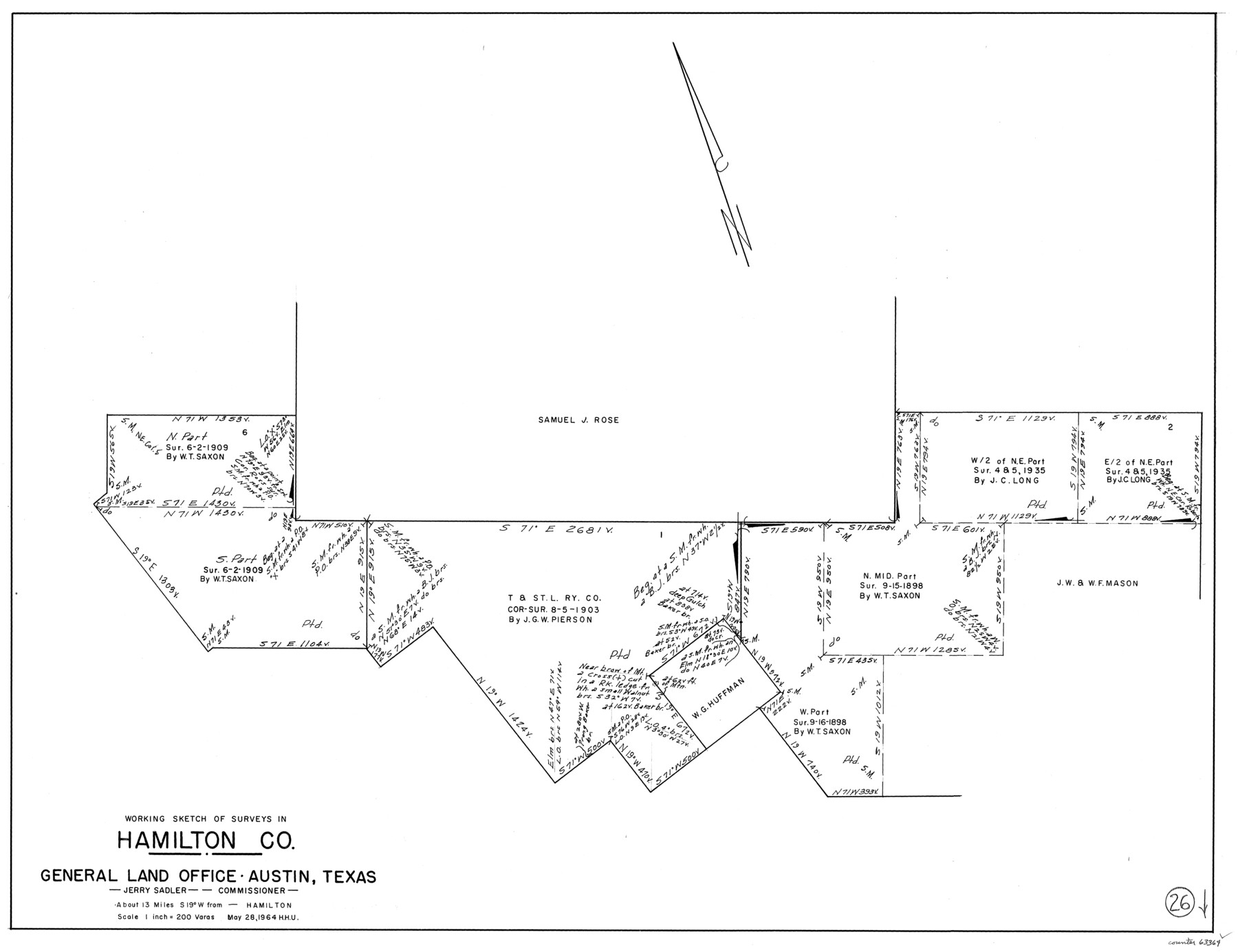
Hamilton County Working Sketch 26
-
Map/Doc
63364
-
Collection
General Map Collection
-
Object Dates
5/28/1964 (Creation Date)
-
People and Organizations
Herbert H. Ulbricht (Draftsman)
-
Counties
Hamilton
-
Subjects
Surveying Working Sketch
-
Height x Width
22.8 x 29.6 inches
57.9 x 75.2 cm
-
Scale
1" = 200 varas
Part of: General Map Collection
Hardin County Sketch File 30a

Print $4.00
- Digital $50.00
Hardin County Sketch File 30a
Size 12.1 x 7.7 inches
Map/Doc 25160
Calhoun County NRC Article 33.136 Sketch 5

Print $34.00
- Digital $50.00
Calhoun County NRC Article 33.136 Sketch 5
2012
Size 24.0 x 36.0 inches
Map/Doc 94633
La Salle County Rolled Sketch 28

Print $90.00
- Digital $50.00
La Salle County Rolled Sketch 28
1956
Size 51.1 x 49.1 inches
Map/Doc 9561
Oldham County Working Sketch 5

Print $40.00
- Digital $50.00
Oldham County Working Sketch 5
1951
Size 43.0 x 59.3 inches
Map/Doc 71327
Newton County Rolled Sketch 20

Print $40.00
- Digital $50.00
Newton County Rolled Sketch 20
1956
Size 41.4 x 48.0 inches
Map/Doc 9581
Frio County Working Sketch 8

Print $20.00
- Digital $50.00
Frio County Working Sketch 8
1948
Size 26.9 x 21.3 inches
Map/Doc 69282
La Salle County Working Sketch 50

Print $40.00
- Digital $50.00
La Salle County Working Sketch 50
1985
Size 50.6 x 26.2 inches
Map/Doc 70351
Refugio County Working Sketch Graphic Index

Print $20.00
- Digital $50.00
Refugio County Working Sketch Graphic Index
1921
Size 38.9 x 47.8 inches
Map/Doc 76683
Flight Mission No. BQR-13K, Frame 21, Brazoria County

Print $20.00
- Digital $50.00
Flight Mission No. BQR-13K, Frame 21, Brazoria County
1952
Size 18.8 x 22.4 inches
Map/Doc 84069
Map of Cherokee County

Print $20.00
- Digital $50.00
Map of Cherokee County
1871
Size 25.0 x 17.6 inches
Map/Doc 3388
Angelina County Boundary File 2

Print $20.00
- Digital $50.00
Angelina County Boundary File 2
Size 10.2 x 28.2 inches
Map/Doc 49773
Crockett County Rolled Sketch 69

Print $40.00
- Digital $50.00
Crockett County Rolled Sketch 69
1949
Size 39.4 x 54.8 inches
Map/Doc 8721
You may also like
No. IX - Outline map of the vicinity of Corpus Christi

Print $20.00
- Digital $50.00
No. IX - Outline map of the vicinity of Corpus Christi
Size 24.8 x 18.3 inches
Map/Doc 72967
Kerr County Rolled Sketch 16

Print $20.00
- Digital $50.00
Kerr County Rolled Sketch 16
1951
Size 40.6 x 31.1 inches
Map/Doc 9346
Cameron County

Print $20.00
- Digital $50.00
Cameron County
1913
Size 29.3 x 33.6 inches
Map/Doc 4902

Mapa de los Estados Unidos de Méjico, Segun lo organizado y definido por las varias actas del Congreso de dicha Republica: y construido por las mejores autoridades

Print $20.00
Mapa de los Estados Unidos de Méjico, Segun lo organizado y definido por las varias actas del Congreso de dicha Republica: y construido por las mejores autoridades
1847
Size 29.6 x 42.4 inches
Map/Doc 76221
San Patricio County Sketch File 18

Print $4.00
San Patricio County Sketch File 18
Size 6.2 x 8.3 inches
Map/Doc 36066
Brazos River, Brazos River Sheet 7

Print $20.00
- Digital $50.00
Brazos River, Brazos River Sheet 7
1926
Size 22.8 x 27.8 inches
Map/Doc 69671
[Section 1, Block 12, H. & G. N. RR. Co.]
![91651, [Section 1, Block 12, H. & G. N. RR. Co.], Twichell Survey Records](https://historictexasmaps.com/wmedia_w700/maps/91651-1.tif.jpg)
Print $3.00
- Digital $50.00
[Section 1, Block 12, H. & G. N. RR. Co.]
Size 12.9 x 9.6 inches
Map/Doc 91651
Terrell County Working Sketch 50

Print $40.00
- Digital $50.00
Terrell County Working Sketch 50
1958
Size 43.0 x 64.3 inches
Map/Doc 62143
Morton, Cochran County, Texas / Morton Cemetery First Addition, Cochran County, Texas

Print $20.00
- Digital $50.00
Morton, Cochran County, Texas / Morton Cemetery First Addition, Cochran County, Texas
Size 37.4 x 40.3 inches
Map/Doc 89853
Refugio County NRC Article 33.136 Sketch 4

Print $46.00
- Digital $50.00
Refugio County NRC Article 33.136 Sketch 4
2014
Size 18.0 x 24.0 inches
Map/Doc 94491
Parmer County

Print $20.00
- Digital $50.00
Parmer County
1926
Size 43.9 x 35.4 inches
Map/Doc 73259