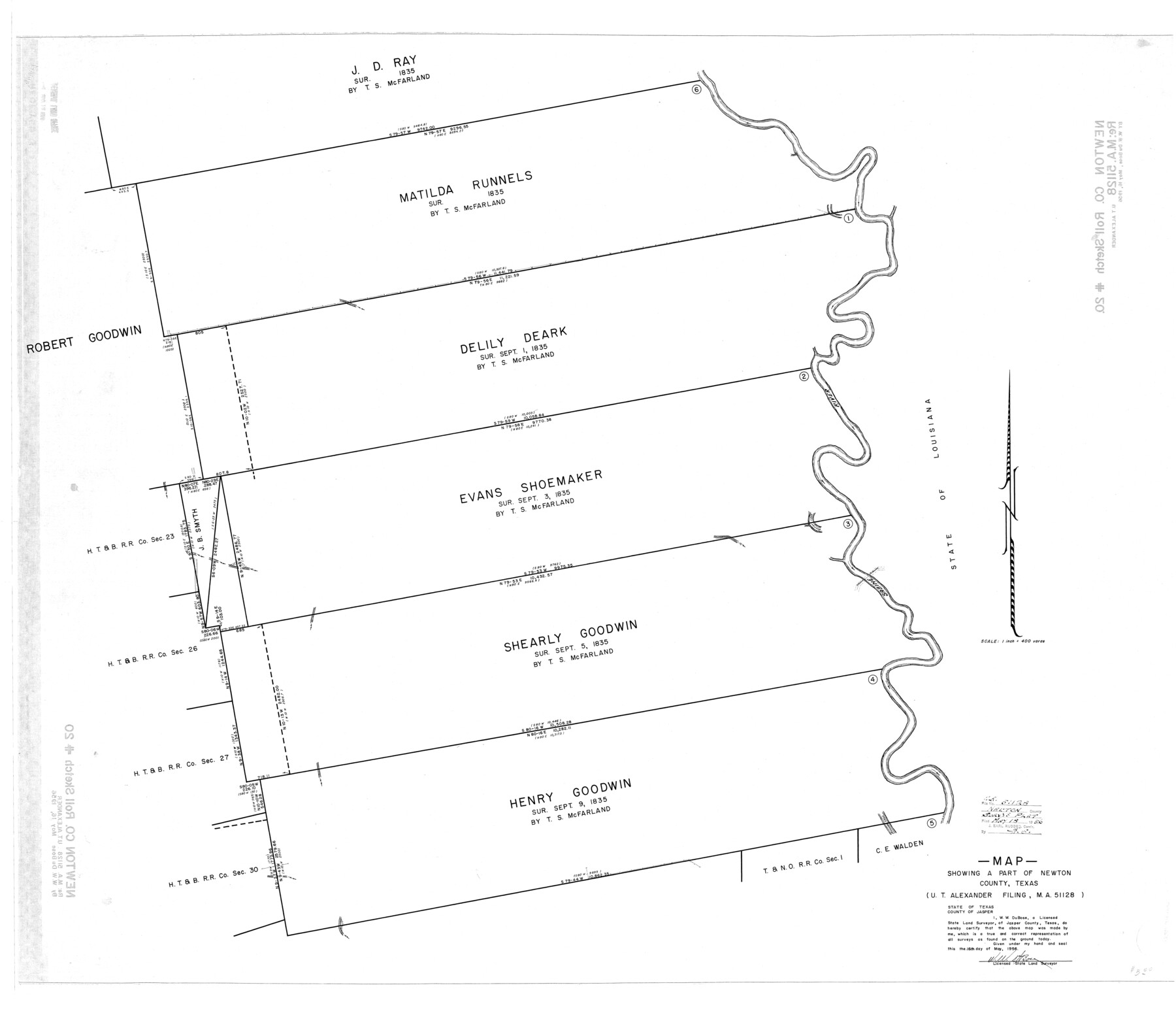
Newton County Rolled Sketch 20
Map showing a part of Newton County, Texas (U.T. Alexander filing, MA-51128)
-
Map/Doc
9581
-
Collection
General Map Collection
-
Object Dates
1956/5/16 (Creation Date)
1956/5/18 (File Date)
-
People and Organizations
W.W. DuBose (Surveyor/Engineer)
-
Counties
Newton
-
Subjects
Surveying Rolled Sketch
-
Height x Width
41.4 x 48.0 inches
105.2 x 121.9 cm
-
Scale
1" = 400 varas
Part of: General Map Collection
Lynn County Sketch File 1b

Print $8.00
- Digital $50.00
Lynn County Sketch File 1b
1940
Size 8.7 x 11.3 inches
Map/Doc 30515
Navarro County Working Sketch 4

Print $20.00
- Digital $50.00
Navarro County Working Sketch 4
1922
Size 20.8 x 20.9 inches
Map/Doc 71234
Oldham County Boundary File 1b

Print $48.00
- Digital $50.00
Oldham County Boundary File 1b
Size 14.0 x 8.5 inches
Map/Doc 57747
Houston County Sketch File 4

Print $24.00
- Digital $50.00
Houston County Sketch File 4
1859
Size 12.7 x 8.3 inches
Map/Doc 26751
Johnson County Working Sketch 4

Print $20.00
- Digital $50.00
Johnson County Working Sketch 4
1948
Size 26.5 x 24.6 inches
Map/Doc 66617
Andrews County Working Sketch 26

Print $20.00
- Digital $50.00
Andrews County Working Sketch 26
1983
Size 34.3 x 37.5 inches
Map/Doc 67072
Map of the Fort Worth & Denver City Ry., Dallam County, Texas

Print $40.00
- Digital $50.00
Map of the Fort Worth & Denver City Ry., Dallam County, Texas
1887
Size 21.3 x 111.8 inches
Map/Doc 64352
Cameron County Rolled Sketch 24

Print $40.00
- Digital $50.00
Cameron County Rolled Sketch 24
1968
Size 30.4 x 66.7 inches
Map/Doc 8574
McMullen County Sketch File 25

Print $6.00
- Digital $50.00
McMullen County Sketch File 25
1877
Size 8.5 x 14.2 inches
Map/Doc 31383
Briscoe County Sketch File F

Print $40.00
- Digital $50.00
Briscoe County Sketch File F
1917
Size 20.9 x 19.3 inches
Map/Doc 76756
San Patricio County NRC Article 33.136 Sketch 6

Print $24.00
- Digital $50.00
San Patricio County NRC Article 33.136 Sketch 6
2010
Size 22.0 x 34.0 inches
Map/Doc 94472
Culberson County Rolled Sketch 36

Print $20.00
- Digital $50.00
Culberson County Rolled Sketch 36
1934
Size 32.5 x 23.2 inches
Map/Doc 8750
You may also like
A Map of Louisiana and Mexico

Print $20.00
- Digital $50.00
A Map of Louisiana and Mexico
1820
Size 43.8 x 32.9 inches
Map/Doc 94945
Liberty County Working Sketch 69

Print $20.00
- Digital $50.00
Liberty County Working Sketch 69
1972
Size 29.8 x 41.8 inches
Map/Doc 70529
[Sketch for Mineral Application 16700 - Pecos River Bed]
![2806, [Sketch for Mineral Application 16700 - Pecos River Bed], General Map Collection](https://historictexasmaps.com/wmedia_w700/maps/2806.tif.jpg)
Print $20.00
- Digital $50.00
[Sketch for Mineral Application 16700 - Pecos River Bed]
1927
Size 20.3 x 29.1 inches
Map/Doc 2806
Gillespie County Boundary File 1

Print $30.00
- Digital $50.00
Gillespie County Boundary File 1
Size 8.5 x 3.8 inches
Map/Doc 53709
Gonzales County Sketch File 4

Print $4.00
- Digital $50.00
Gonzales County Sketch File 4
Size 12.6 x 8.0 inches
Map/Doc 24373
Official Highway Map of Texas

Print $20.00
Official Highway Map of Texas
1928
Size 42.3 x 46.2 inches
Map/Doc 79746
Aransas County NRC Article 33.136 Sketch 21

Print $138.00
Aransas County NRC Article 33.136 Sketch 21
2024
Map/Doc 97269
![90594, [Block K7], Twichell Survey Records](https://historictexasmaps.com/wmedia_w700/maps/90594-1.tif.jpg)
Flight Mission No. DIX-10P, Frame 149, Aransas County

Print $20.00
- Digital $50.00
Flight Mission No. DIX-10P, Frame 149, Aransas County
1956
Size 18.6 x 22.3 inches
Map/Doc 83951
Webb County Sketch File 53

Print $20.00
- Digital $50.00
Webb County Sketch File 53
1939
Size 18.7 x 14.5 inches
Map/Doc 12649
Map of Part of the YL Ranch

Print $20.00
- Digital $50.00
Map of Part of the YL Ranch
1917
Size 29.1 x 27.3 inches
Map/Doc 4442
Atascosa County Working Sketch 11

Print $20.00
- Digital $50.00
Atascosa County Working Sketch 11
1923
Size 13.9 x 17.1 inches
Map/Doc 67207