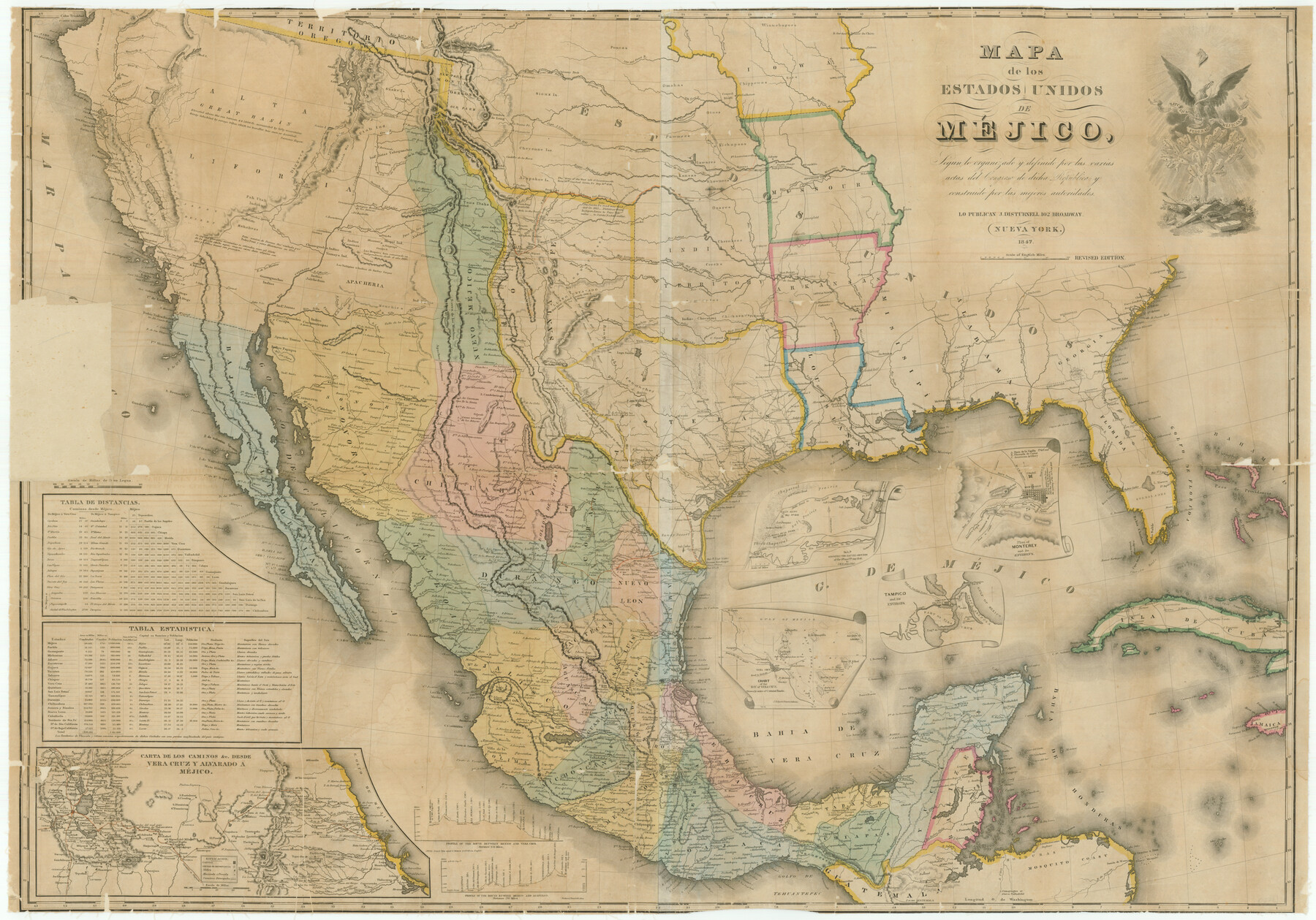
Mapa de los Estados Unidos de Méjico, Segun lo organizado y definido por las varias actas del Congreso de dicha Republica: y construido por las mejores autoridades
[Translated: Map of the United States of Mexico according to what is organized and defined by the various acts of the Congress of said Republic; and compiled by the best authorities.]
-
Map/Doc
76221
-
Collection
Texas State Library and Archives
-
Object Dates
1847 (Creation Date)
-
People and Organizations
J. Disturnell (Publisher)
-
Subjects
Mexico
-
Height x Width
29.6 x 42.4 inches
75.2 x 107.7 cm
-
Comments
Prints available courtesy of the Texas State Library and Archives.
More info can be found here: TSLAC Map 01028
Part of: Texas State Library and Archives
General Highway Map, Andrews County, Texas

Print $20.00
General Highway Map, Andrews County, Texas
1961
Size 25.2 x 18.2 inches
Map/Doc 79348
General Highway Map, Zapata County, Texas

Print $20.00
General Highway Map, Zapata County, Texas
1940
Size 18.3 x 24.9 inches
Map/Doc 79288
General Highway Map, Henderson County, Texas

Print $20.00
General Highway Map, Henderson County, Texas
1939
Size 18.3 x 25.0 inches
Map/Doc 79125
General Highway Map, Denton County, Texas

Print $20.00
General Highway Map, Denton County, Texas
1961
Size 18.2 x 24.5 inches
Map/Doc 79441
Oil and Gas Fields in the State of Texas

Print $40.00
Oil and Gas Fields in the State of Texas
1927
Size 58.0 x 38.0 inches
Map/Doc 76304
General Highway Map, Frio County, Texas

Print $20.00
General Highway Map, Frio County, Texas
1940
Size 18.4 x 24.9 inches
Map/Doc 79095
General Highway Map, Jasper County, Newton County, Texas

Print $20.00
General Highway Map, Jasper County, Newton County, Texas
1940
Size 18.6 x 25.2 inches
Map/Doc 79142

Rand McNally Standard Map of Texas (reverse)

Print $20.00
Rand McNally Standard Map of Texas (reverse)
1923
Size 39.8 x 27.2 inches
Map/Doc 76229
General Highway Map, Kaufman County, Texas

Print $20.00
General Highway Map, Kaufman County, Texas
1939
Size 24.8 x 18.3 inches
Map/Doc 79152
Map of Texas compiled from surveys recorded in the Land Office of Texas, and other official surveys

Print $20.00
Map of Texas compiled from surveys recorded in the Land Office of Texas, and other official surveys
1841
Size 25.1 x 20.4 inches
Map/Doc 76253
General Highway Map. Detail of Cities and Towns in Grayson County, Texas [Denison and Sherman]
![79486, General Highway Map. Detail of Cities and Towns in Grayson County, Texas [Denison and Sherman], Texas State Library and Archives](https://historictexasmaps.com/wmedia_w700/maps/79486.tif.jpg)
Print $20.00
General Highway Map. Detail of Cities and Towns in Grayson County, Texas [Denison and Sherman]
1961
Size 18.1 x 24.6 inches
Map/Doc 79486
You may also like
Crockett County Rolled Sketch 68

Print $20.00
- Digital $50.00
Crockett County Rolled Sketch 68
1947
Size 25.8 x 38.7 inches
Map/Doc 5611
Garden City, Tom Green County, Texas, Section 5, Range 4-S Block 33

Print $3.00
- Digital $50.00
Garden City, Tom Green County, Texas, Section 5, Range 4-S Block 33
1886
Size 10.0 x 16.6 inches
Map/Doc 92130
Flight Mission No. DQO-1K, Frame 117, Galveston County

Print $20.00
- Digital $50.00
Flight Mission No. DQO-1K, Frame 117, Galveston County
1952
Size 18.9 x 22.5 inches
Map/Doc 84995
Knox County Sketch File 17

Print $20.00
- Digital $50.00
Knox County Sketch File 17
1902
Size 18.4 x 25.0 inches
Map/Doc 11960

Oldham County Sketch File 20

Print $6.00
- Digital $50.00
Oldham County Sketch File 20
1916
Size 11.1 x 8.5 inches
Map/Doc 33275
Hill County Boundary File 45a

Print $54.00
- Digital $50.00
Hill County Boundary File 45a
Size 14.4 x 9.0 inches
Map/Doc 54763
Flight Mission No. CUG-3P, Frame 193, Kleberg County

Print $20.00
- Digital $50.00
Flight Mission No. CUG-3P, Frame 193, Kleberg County
1956
Size 18.4 x 22.3 inches
Map/Doc 86297
Flight Mission No. CRK-8P, Frame 114, Refugio County

Print $20.00
- Digital $50.00
Flight Mission No. CRK-8P, Frame 114, Refugio County
1956
Size 18.3 x 22.1 inches
Map/Doc 86969

Map of Comal County

Print $20.00
- Digital $50.00
Map of Comal County
1879
Size 19.3 x 25.7 inches
Map/Doc 4521
United States Gulf Coast - from Galveston to the Rio Grande

Print $20.00
- Digital $50.00
United States Gulf Coast - from Galveston to the Rio Grande
1915
Size 26.3 x 18.3 inches
Map/Doc 72731