Refugio County NRC Article 33.136 Sketch 4
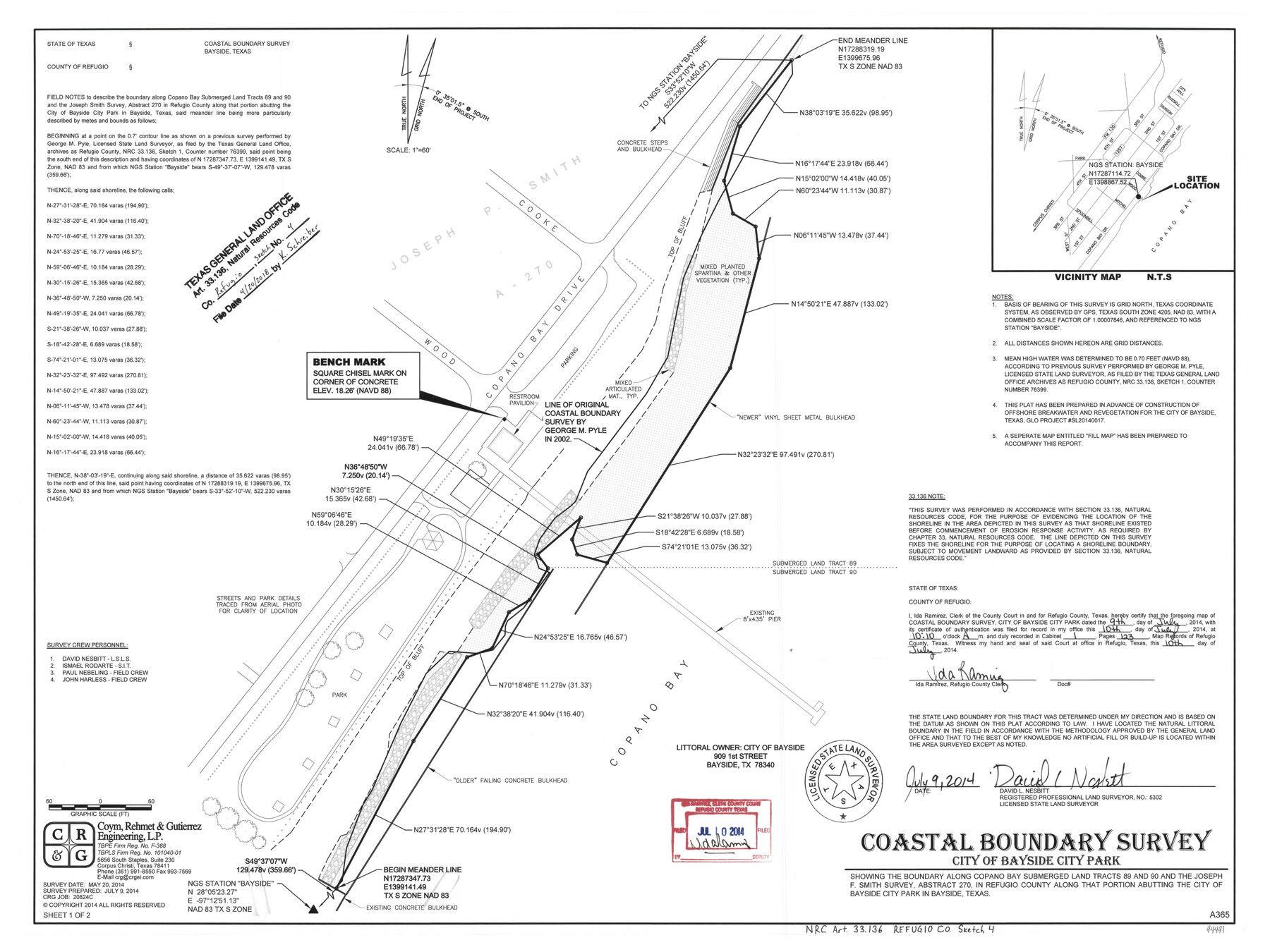
Coastal Boundary Survey, City of Bayside City Park, showing the boundary along Copano Bay submerged land tracts 89 and 90 and the Joseph F. Smith survey, abstract 270, in Refugio County along that portion abutting the city of Bayside City Park
-
Map/Doc
94491
-
Collection
General Map Collection
-
Object Dates
2014/7/9 (Creation Date)
2018/4/20 (File Date)
-
People and Organizations
David L. Nesbitt (Surveyor/Engineer)
-
Counties
Refugio
-
Subjects
Surveying CBS
-
Height x Width
18.0 x 24.0 inches
45.7 x 61.0 cm
-
Medium
multi-page, multi-format
-
Comments
Project: Bayside Shoreline Protection Project No.: SL20140017
Part of: General Map Collection
Culberson County Working Sketch 24

Print $20.00
- Digital $50.00
Culberson County Working Sketch 24
1947
Size 36.8 x 36.2 inches
Map/Doc 68477
Port Mansfield

Print $20.00
- Digital $50.00
Port Mansfield
1968
Size 37.1 x 44.2 inches
Map/Doc 3043
Cherokee County Working Sketch 28

Print $20.00
- Digital $50.00
Cherokee County Working Sketch 28
1991
Size 13.7 x 16.8 inches
Map/Doc 67983
Flight Mission No. DQN-1K, Frame 51, Calhoun County

Print $20.00
- Digital $50.00
Flight Mission No. DQN-1K, Frame 51, Calhoun County
1953
Size 18.6 x 22.3 inches
Map/Doc 84151
Harris County Working Sketch Graphic Index, Sheet 2 (Sketches 69 to Most Recent)

Print $20.00
- Digital $50.00
Harris County Working Sketch Graphic Index, Sheet 2 (Sketches 69 to Most Recent)
1940
Size 38.5 x 46.2 inches
Map/Doc 76569
Ector County Working Sketch 19

Print $40.00
- Digital $50.00
Ector County Working Sketch 19
1958
Size 65.8 x 37.6 inches
Map/Doc 68862
Sulphur River, Ringo Crossing Sheet

Print $20.00
- Digital $50.00
Sulphur River, Ringo Crossing Sheet
1933
Size 30.5 x 35.9 inches
Map/Doc 65162
Flight Mission No. BRA-7M, Frame 19, Jefferson County

Print $20.00
- Digital $50.00
Flight Mission No. BRA-7M, Frame 19, Jefferson County
1953
Size 18.8 x 22.4 inches
Map/Doc 85470
Aransas County Rolled Sketch 4

Print $20.00
- Digital $50.00
Aransas County Rolled Sketch 4
1952
Size 28.9 x 26.4 inches
Map/Doc 77189
Flight Mission No. BRE-2P, Frame 100, Nueces County

Print $20.00
- Digital $50.00
Flight Mission No. BRE-2P, Frame 100, Nueces County
1956
Size 18.5 x 22.3 inches
Map/Doc 86785
Flight Mission No. DCL-7C, Frame 77, Kenedy County

Print $20.00
- Digital $50.00
Flight Mission No. DCL-7C, Frame 77, Kenedy County
1943
Size 15.3 x 15.2 inches
Map/Doc 86063
Cherokee County Working Sketch 11

Print $20.00
- Digital $50.00
Cherokee County Working Sketch 11
1957
Size 24.3 x 20.2 inches
Map/Doc 67966
You may also like
Matagorda County NRC Article 33.136 Sketch 3

Print $20.00
- Digital $50.00
Matagorda County NRC Article 33.136 Sketch 3
2008
Size 36.0 x 24.0 inches
Map/Doc 88834
Lebanon Quadrangle

Print $20.00
- Digital $50.00
Lebanon Quadrangle
1999
Size 35.4 x 23.4 inches
Map/Doc 97360

Controlled Mosaic by Jack Amman Photogrammetric Engineers, Inc - Sheet 20

Print $20.00
- Digital $50.00
Controlled Mosaic by Jack Amman Photogrammetric Engineers, Inc - Sheet 20
1954
Size 20.0 x 24.0 inches
Map/Doc 83467
Tyler County Sketch File 1a

Print $4.00
- Digital $50.00
Tyler County Sketch File 1a
1855
Size 8.2 x 10.3 inches
Map/Doc 38609
Texas Intracoastal Waterway - Port O'Connor to San Antonio Bay, Including Pass Cavallo

Print $20.00
- Digital $50.00
Texas Intracoastal Waterway - Port O'Connor to San Antonio Bay, Including Pass Cavallo
1957
Size 28.1 x 40.0 inches
Map/Doc 73372
Fort Bend County Working Sketch 2

Print $20.00
- Digital $50.00
Fort Bend County Working Sketch 2
1897
Size 18.3 x 28.4 inches
Map/Doc 69208
Uvalde County Sketch File 4

Print $22.00
- Digital $50.00
Uvalde County Sketch File 4
1879
Size 12.8 x 8.3 inches
Map/Doc 38951
Map of the route of B'vt. Maj. A. Moore's scout, April 11th to June 12th 1869

Print $20.00
Map of the route of B'vt. Maj. A. Moore's scout, April 11th to June 12th 1869
1872
Size 23.6 x 40.9 inches
Map/Doc 93566
Travis County Sketch File 43

Print $30.00
- Digital $50.00
Travis County Sketch File 43
1887
Size 8.8 x 9.3 inches
Map/Doc 38359
Anderson County Boundary File 4

Print $10.00
- Digital $50.00
Anderson County Boundary File 4
Size 8.9 x 7.4 inches
Map/Doc 49737
Clason's Oil Map of Texas and Oklahoma showing the location and approximate area of the oil and gas fields

Print $20.00
- Digital $50.00
Clason's Oil Map of Texas and Oklahoma showing the location and approximate area of the oil and gas fields
1919
Size 22.4 x 24.5 inches
Map/Doc 97158