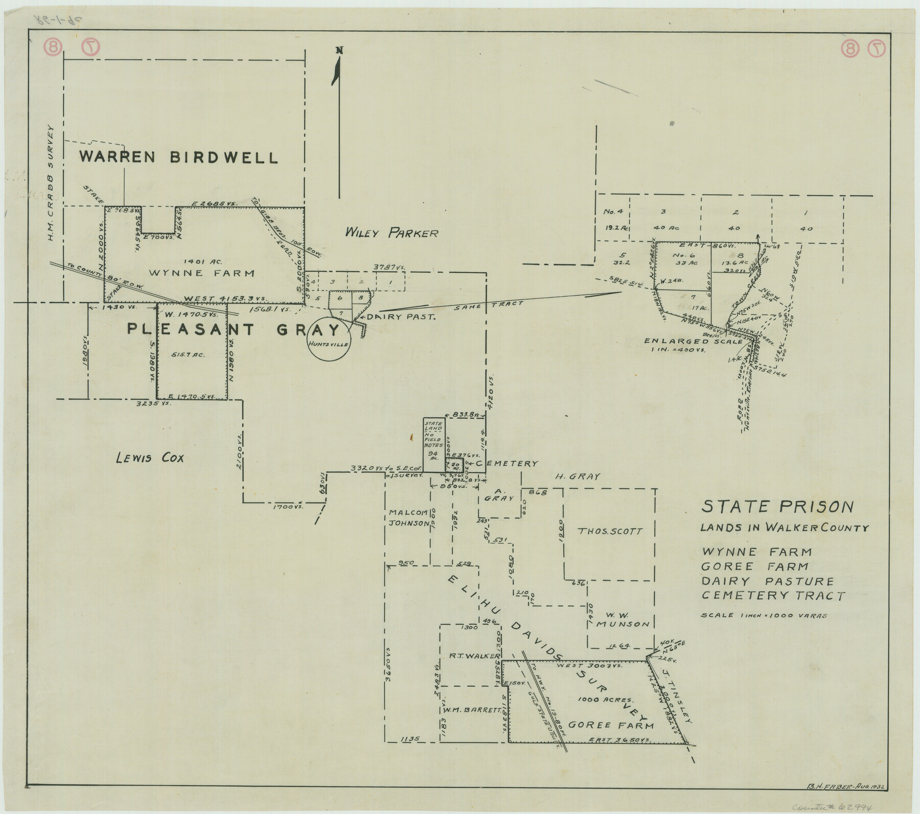
State Prison Lands in Walker County - Wynne Farm, Goree Farm, Dairy Pasture, Cemetery Tract
RG-1-9c
-
Map/Doc
62994
-
Collection
General Map Collection
-
People and Organizations
R.J. McMahon (Author)
-
Counties
Walker
-
Subjects
Prison Farms
-
Height x Width
16.9 x 19.1 inches
42.9 x 48.5 cm
Part of: General Map Collection
Live Oak County Working Sketch 37

Print $40.00
- Digital $50.00
Live Oak County Working Sketch 37
2012
Size 34.4 x 48.7 inches
Map/Doc 93363
Zapata County Working Sketch 4

Print $20.00
- Digital $50.00
Zapata County Working Sketch 4
1935
Size 19.6 x 22.1 inches
Map/Doc 62055
Brewster County Working Sketch 118

Print $20.00
- Digital $50.00
Brewster County Working Sketch 118
1929
Size 27.0 x 20.5 inches
Map/Doc 67718
Newton County Sketch File 11

Print $4.00
- Digital $50.00
Newton County Sketch File 11
1876
Size 7.9 x 12.7 inches
Map/Doc 32380
Yoakum County Rolled Sketch 2

Print $20.00
- Digital $50.00
Yoakum County Rolled Sketch 2
1943
Size 18.6 x 33.4 inches
Map/Doc 8288
Real County Sketch File 11

Print $8.00
- Digital $50.00
Real County Sketch File 11
1932
Size 11.2 x 8.8 inches
Map/Doc 35065
Cameron County Rolled Sketch 20D

Print $20.00
- Digital $50.00
Cameron County Rolled Sketch 20D
Size 14.3 x 13.9 inches
Map/Doc 5477
Coke County Boundary File 4

Print $44.00
- Digital $50.00
Coke County Boundary File 4
Size 14.3 x 8.7 inches
Map/Doc 51593
Kenedy County Boundary File 2a

Print $22.00
- Digital $50.00
Kenedy County Boundary File 2a
Size 14.7 x 40.9 inches
Map/Doc 55793
Hutchinson County Working Sketch 13

Print $20.00
- Digital $50.00
Hutchinson County Working Sketch 13
1926
Size 22.6 x 31.5 inches
Map/Doc 66371

San Patricio County Rolled Sketch 48

Print $20.00
- Digital $50.00
San Patricio County Rolled Sketch 48
1984
Size 37.0 x 25.6 inches
Map/Doc 7733
You may also like
Galveston County Sketch File 8

Print $4.00
- Digital $50.00
Galveston County Sketch File 8
1862
Size 11.2 x 8.8 inches
Map/Doc 23365
Crosby County Working Sketch 15

Print $20.00
- Digital $50.00
Crosby County Working Sketch 15
1977
Size 34.0 x 35.9 inches
Map/Doc 68449
[Southern Part of County]
![91905, [Southern Part of County], Twichell Survey Records](https://historictexasmaps.com/wmedia_w700/maps/91905-1.tif.jpg)
Print $2.00
- Digital $50.00
[Southern Part of County]
Size 9.8 x 7.6 inches
Map/Doc 91905
Outer Continental Shelf Leasing Maps (Texas Offshore Operations)

Print $20.00
- Digital $50.00
Outer Continental Shelf Leasing Maps (Texas Offshore Operations)
Size 17.3 x 16.7 inches
Map/Doc 75841
Mills County Sketch File 17

Print $10.00
- Digital $50.00
Mills County Sketch File 17
1912
Size 14.4 x 8.8 inches
Map/Doc 31665
Coke County Working Sketch 19

Print $20.00
- Digital $50.00
Coke County Working Sketch 19
1948
Size 22.2 x 29.0 inches
Map/Doc 68056
Wilbarger County Sketch File 13

Print $28.00
- Digital $50.00
Wilbarger County Sketch File 13
1885
Size 12.7 x 8.0 inches
Map/Doc 40189
Polk County Sketch File 29 1/2

Print $4.00
- Digital $50.00
Polk County Sketch File 29 1/2
Size 8.7 x 12.5 inches
Map/Doc 34204
Bailey County Sketch File 11

Print $80.00
- Digital $50.00
Bailey County Sketch File 11
Size 21.6 x 20.5 inches
Map/Doc 10886
Concho County
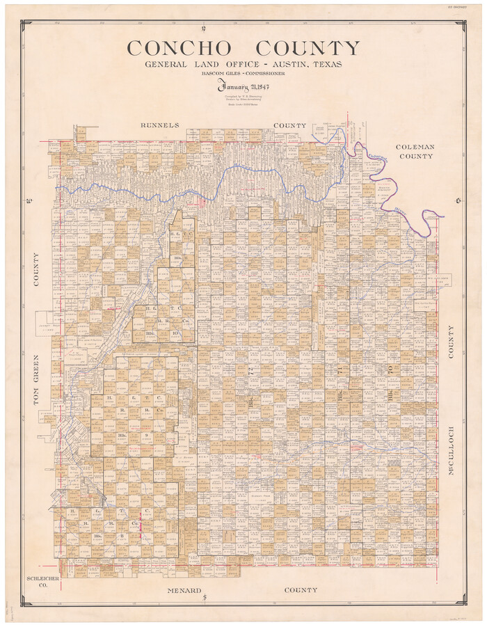
Print $20.00
- Digital $50.00
Concho County
1947
Size 46.8 x 36.9 inches
Map/Doc 73115
Harris County Historic Topographic 33

Print $20.00
- Digital $50.00
Harris County Historic Topographic 33
1916
Size 29.3 x 22.8 inches
Map/Doc 65844
Upton County Sketch File 10

Print $18.00
- Digital $50.00
Upton County Sketch File 10
1919
Size 13.5 x 8.7 inches
Map/Doc 38839