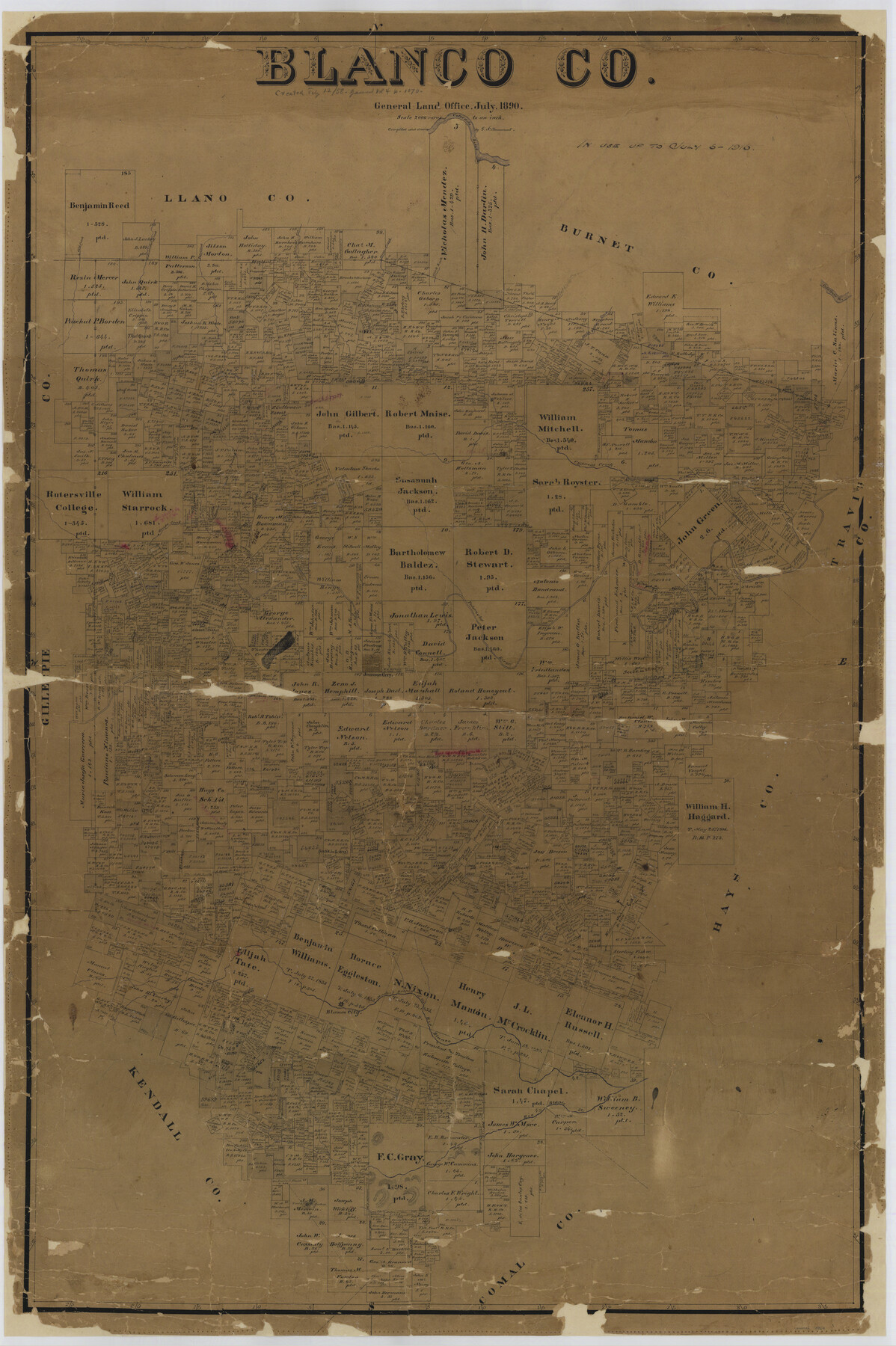
Blanco Co.
-
Map/Doc
4764
-
Collection
General Map Collection
-
Object Dates
1890 (Creation Date)
-
People and Organizations
Texas General Land Office (Publisher)
G.N. Beaumont (Compiler)
G.N. Beaumont (Draftsman)
-
Counties
Blanco
-
Subjects
County
-
Height x Width
48.0 x 32.0 inches
121.9 x 81.3 cm
-
Comments
In use to July 1916.
Conservation funded in 2002 with donation from Renson Enterprises Ltd. -
Features
Slick Rock Creek
Rio Blanco
Blanco City
Martin's Branch of the Rio Blanco
Johnson City
Pedernales River
Grape Creek
Spring Creek
Hickory Creek
Cypress Creek
Lost Creek
Hammetts Crossing
Flat Rock Creek
Double Horn Creek
Pecan Creek
Walnut Creek
Pots Creek
Comanche Creek
Cold Creek
Colorado River
Twin Sisters
Part of: General Map Collection
Newton County Rolled Sketch 16

Print $20.00
- Digital $50.00
Newton County Rolled Sketch 16
Size 30.5 x 21.9 inches
Map/Doc 6846
Flight Mission No. DCL-7C, Frame 118, Kenedy County

Print $20.00
- Digital $50.00
Flight Mission No. DCL-7C, Frame 118, Kenedy County
1943
Size 18.4 x 22.3 inches
Map/Doc 86083
East Line & Red River Railroad, Map of the Line from Sulphur Springs to Greenville

Print $40.00
- Digital $50.00
East Line & Red River Railroad, Map of the Line from Sulphur Springs to Greenville
1881
Size 19.0 x 88.2 inches
Map/Doc 64350
Right of Way and Track Map, the Missouri, Kansas and Texas Ry. of Texas operated by the Missouri, Kansas and Texas Ry. of Texas, San Antonio Division

Print $40.00
- Digital $50.00
Right of Way and Track Map, the Missouri, Kansas and Texas Ry. of Texas operated by the Missouri, Kansas and Texas Ry. of Texas, San Antonio Division
1918
Size 25.2 x 58.8 inches
Map/Doc 64584
Township No. 2 South Range No. 21 West of the Indian Meridian

Print $20.00
- Digital $50.00
Township No. 2 South Range No. 21 West of the Indian Meridian
1875
Size 19.3 x 24.4 inches
Map/Doc 75177
Cottle County Rolled Sketch B

Print $20.00
- Digital $50.00
Cottle County Rolled Sketch B
1903
Size 32.5 x 43.4 inches
Map/Doc 8671
Brooks County Boundary File 2

Print $8.00
- Digital $50.00
Brooks County Boundary File 2
Size 8.6 x 11.3 inches
Map/Doc 50839
Flight Mission No. CGI-4N, Frame 29, Cameron County

Print $20.00
- Digital $50.00
Flight Mission No. CGI-4N, Frame 29, Cameron County
1954
Size 18.6 x 22.4 inches
Map/Doc 84662
Flight Mission No. DIX-6P, Frame 202, Aransas County

Print $20.00
- Digital $50.00
Flight Mission No. DIX-6P, Frame 202, Aransas County
1956
Size 19.2 x 22.7 inches
Map/Doc 83864
King County Sketch File 2

Print $4.00
- Digital $50.00
King County Sketch File 2
1882
Size 13.2 x 9.2 inches
Map/Doc 29020
Starr County Sketch File 43

Print $28.00
- Digital $50.00
Starr County Sketch File 43
1941
Size 14.7 x 9.1 inches
Map/Doc 36991
Map of Jones County

Print $20.00
- Digital $50.00
Map of Jones County
1898
Size 41.9 x 39.8 inches
Map/Doc 4996
You may also like
Blanco County Boundary File 7

Print $58.00
- Digital $50.00
Blanco County Boundary File 7
Size 14.3 x 8.5 inches
Map/Doc 50565
Starr County Working Sketch 8

Print $20.00
- Digital $50.00
Starr County Working Sketch 8
1939
Size 21.9 x 28.8 inches
Map/Doc 63924
Crockett County Working Sketch 43

Print $20.00
- Digital $50.00
Crockett County Working Sketch 43
1931
Size 26.1 x 21.7 inches
Map/Doc 68376
Real County Sketch File 2

Print $4.00
- Digital $50.00
Real County Sketch File 2
1884
Size 13.4 x 8.5 inches
Map/Doc 35037
Liberty County Sketch File 30

Print $6.00
- Digital $50.00
Liberty County Sketch File 30
Size 10.5 x 11.3 inches
Map/Doc 29957
[Blocks A-23, A-26, and A-31]
![92673, [Blocks A-23, A-26, and A-31], Twichell Survey Records](https://historictexasmaps.com/wmedia_w700/maps/92673-1.tif.jpg)
Print $20.00
- Digital $50.00
[Blocks A-23, A-26, and A-31]
1954
Size 18.1 x 9.0 inches
Map/Doc 92673
Lamar County State Real Property Sketch 1

Print $20.00
- Digital $50.00
Lamar County State Real Property Sketch 1
2013
Size 24.0 x 36.0 inches
Map/Doc 93661
Nolan County Working Sketch 10

Print $40.00
- Digital $50.00
Nolan County Working Sketch 10
1971
Size 78.9 x 37.0 inches
Map/Doc 71301
Flight Mission No. DAG-16K, Frame 71, Matagorda County

Print $20.00
- Digital $50.00
Flight Mission No. DAG-16K, Frame 71, Matagorda County
1952
Size 16.4 x 16.4 inches
Map/Doc 86317
Galveston County Rolled Sketch Z63

Print $20.00
- Digital $50.00
Galveston County Rolled Sketch Z63
1935
Size 34.6 x 22.5 inches
Map/Doc 5995
Crane County Working Sketch 19

Print $20.00
- Digital $50.00
Crane County Working Sketch 19
1958
Size 28.6 x 38.8 inches
Map/Doc 68296
Jefferson County Sketch File 15

Print $10.00
- Digital $50.00
Jefferson County Sketch File 15
1870
Size 8.6 x 7.6 inches
Map/Doc 28151