Real County Sketch File 11
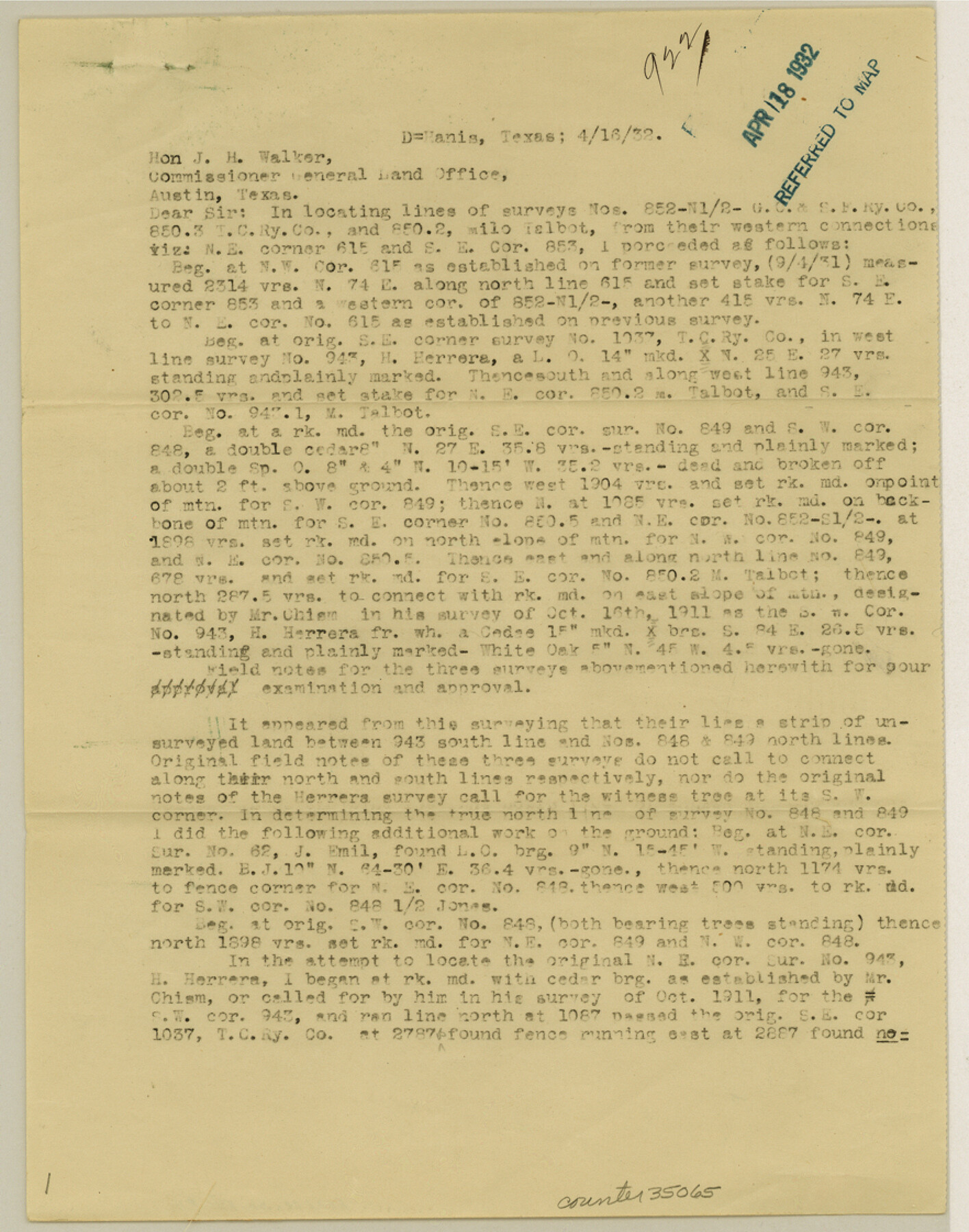
[Surveyor's statement regarding surveys in the southeast corner of Real County near the boundaries with Uvalde and Bandera Counties]
-
Map/Doc
35065
-
Collection
General Map Collection
-
Object Dates
4/16/1932 (Creation Date)
4/18/1932 (File Date)
-
People and Organizations
Arthur H. Rothe (Surveyor/Engineer)
-
Counties
Real Uvalde Bandera
-
Subjects
Surveying Sketch File
-
Height x Width
11.2 x 8.8 inches
28.5 x 22.4 cm
-
Medium
paper, print
-
Comments
See Real County Sketch File 12 (12231) for accompanying sketch.
Related maps
Real County Sketch File 12

Print $20.00
- Digital $50.00
Real County Sketch File 12
1932
Size 13.9 x 19.2 inches
Map/Doc 12231
Real County Sketch File 10

Print $6.00
- Digital $50.00
Real County Sketch File 10
1932
Size 10.3 x 15.0 inches
Map/Doc 35063
Part of: General Map Collection
King County Working Sketch 2

Print $20.00
- Digital $50.00
King County Working Sketch 2
1916
Size 13.6 x 13.9 inches
Map/Doc 70166
Flight Mission No. DCL-7C, Frame 79, Kenedy County

Print $20.00
- Digital $50.00
Flight Mission No. DCL-7C, Frame 79, Kenedy County
1943
Size 15.2 x 15.2 inches
Map/Doc 86065
Galveston County NRC Article 33.136 Sketch 52

Print $26.00
- Digital $50.00
Galveston County NRC Article 33.136 Sketch 52
2008
Size 24.0 x 36.0 inches
Map/Doc 94612
Hemphill County Working Sketch 4

Print $20.00
- Digital $50.00
Hemphill County Working Sketch 4
1940
Size 31.6 x 41.6 inches
Map/Doc 66099
Jefferson County Working Sketch 9

Print $20.00
- Digital $50.00
Jefferson County Working Sketch 9
1937
Size 19.5 x 22.0 inches
Map/Doc 66552
McMullen County Rolled Sketch 7

Print $40.00
- Digital $50.00
McMullen County Rolled Sketch 7
1939
Size 38.8 x 51.7 inches
Map/Doc 9500
Lamar County Sketch File 13

Print $2.00
- Digital $50.00
Lamar County Sketch File 13
1943
Size 10.9 x 8.0 inches
Map/Doc 29307

Flight Mission No. CUG-2P, Frame 63, Kleberg County

Print $20.00
- Digital $50.00
Flight Mission No. CUG-2P, Frame 63, Kleberg County
1956
Size 18.5 x 22.2 inches
Map/Doc 86200
Cooke County Working Sketch 4

Print $20.00
- Digital $50.00
Cooke County Working Sketch 4
1926
Size 23.5 x 17.6 inches
Map/Doc 68241
Brewster County Sketch File NS-4c

Print $6.00
- Digital $50.00
Brewster County Sketch File NS-4c
Size 9.2 x 7.3 inches
Map/Doc 15958
Controlled Mosaic by Jack Amman Photogrammetric Engineers, Inc - Sheet 55

Print $20.00
- Digital $50.00
Controlled Mosaic by Jack Amman Photogrammetric Engineers, Inc - Sheet 55
1954
Size 20.0 x 24.0 inches
Map/Doc 83514
You may also like
M. C. Lindsey's Subdivision of Block 20 College Addition to Lamesa, Texas

Print $20.00
- Digital $50.00
M. C. Lindsey's Subdivision of Block 20 College Addition to Lamesa, Texas
1953
Size 9.6 x 18.2 inches
Map/Doc 92589
Detail Sketch of A.B. Robertson's Ranch and J.W. James' Ranch situated in Garza and Crosby Counties, Texas

Print $40.00
- Digital $50.00
Detail Sketch of A.B. Robertson's Ranch and J.W. James' Ranch situated in Garza and Crosby Counties, Texas
Size 50.9 x 32.4 inches
Map/Doc 89945

Delta County Sketch File 1a

Print $4.00
- Digital $50.00
Delta County Sketch File 1a
Size 8.3 x 8.9 inches
Map/Doc 20668
Dallas County Boundary File 5

Print $120.00
- Digital $50.00
Dallas County Boundary File 5
Size 11.5 x 72.2 inches
Map/Doc 52160
Presidio County Boundary File 4

Print $8.00
- Digital $50.00
Presidio County Boundary File 4
Size 13.9 x 8.6 inches
Map/Doc 58083
United States Atlantic and Gulf Coasts Including Puerto Rico and the Virgin Islands

Print $40.00
- Digital $50.00
United States Atlantic and Gulf Coasts Including Puerto Rico and the Virgin Islands
1989
Size 20.6 x 60.3 inches
Map/Doc 73553
Harris County Working Sketch 92

Print $40.00
- Digital $50.00
Harris County Working Sketch 92
1974
Size 31.7 x 55.4 inches
Map/Doc 65984
Mitchell County Sketch File 5

Print $20.00
- Digital $50.00
Mitchell County Sketch File 5
1906
Size 17.5 x 22.2 inches
Map/Doc 12095
Edwards County Sketch File 44

Print $4.00
- Digital $50.00
Edwards County Sketch File 44
1948
Size 11.4 x 8.9 inches
Map/Doc 21777
Zavala County Working Sketch 11

Print $20.00
- Digital $50.00
Zavala County Working Sketch 11
1955
Size 13.8 x 22.4 inches
Map/Doc 62086
Orange County Sketch File 9b

Print $22.00
- Digital $50.00
Orange County Sketch File 9b
1873
Size 14.6 x 12.6 inches
Map/Doc 33315