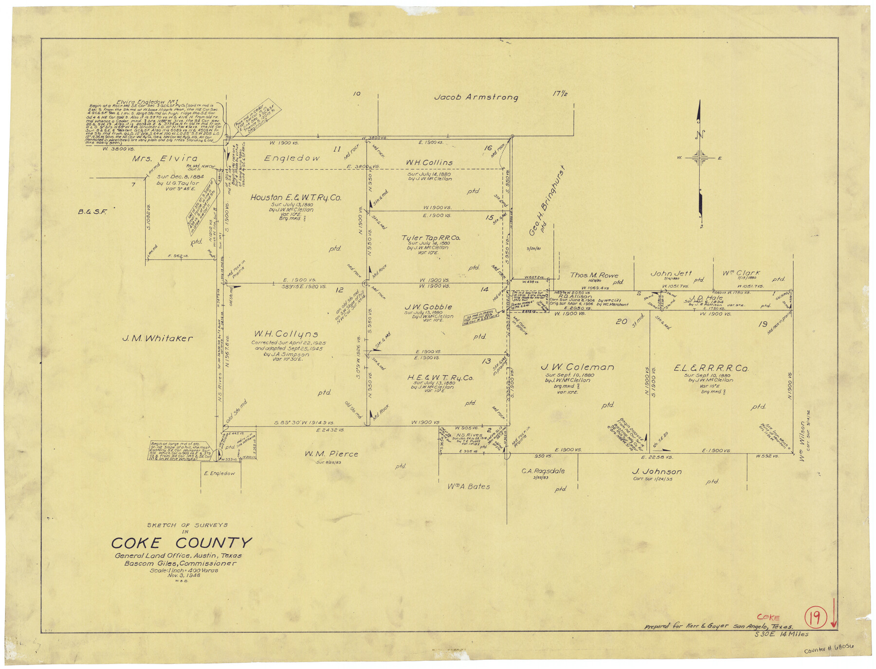
Coke County Working Sketch 19
-
Map/Doc
68056
-
Collection
General Map Collection
-
Object Dates
11/3/1948 (Creation Date)
-
People and Organizations
W. S. Brewington (Draftsman)
-
Counties
Coke
-
Subjects
Surveying Working Sketch
-
Height x Width
22.2 x 29.0 inches
56.4 x 73.7 cm
-
Scale
1" = 400 varas
Part of: General Map Collection
Gaines County Sketch File 13

Print $40.00
- Digital $50.00
Gaines County Sketch File 13
1954
Size 8.9 x 20.4 inches
Map/Doc 23200
Flight Mission No. DAG-23K, Frame 143, Matagorda County

Print $20.00
- Digital $50.00
Flight Mission No. DAG-23K, Frame 143, Matagorda County
1953
Size 15.8 x 15.7 inches
Map/Doc 86491
Floyd County Sketch File 19

Print $6.00
- Digital $50.00
Floyd County Sketch File 19
1913
Size 9.8 x 8.4 inches
Map/Doc 22769
Sutton County Rolled Sketch 41

Print $20.00
- Digital $50.00
Sutton County Rolled Sketch 41
1938
Size 34.5 x 23.3 inches
Map/Doc 7883
Jeff Davis County Rolled Sketch 15

Print $20.00
- Digital $50.00
Jeff Davis County Rolled Sketch 15
1897
Size 20.4 x 17.2 inches
Map/Doc 6368
Duval County Sketch File 87

Print $12.00
- Digital $50.00
Duval County Sketch File 87
1991
Size 11.0 x 8.5 inches
Map/Doc 21549
Map of north end of Brazos Island

Print $20.00
- Digital $50.00
Map of north end of Brazos Island
Size 27.5 x 18.4 inches
Map/Doc 72905

Wheeler County Rolled Sketch 3

Print $20.00
- Digital $50.00
Wheeler County Rolled Sketch 3
Size 31.9 x 21.9 inches
Map/Doc 8239
Bexar County State Real Property Sketch 6

Print $20.00
Bexar County State Real Property Sketch 6
2006
Size 22.2 x 33.1 inches
Map/Doc 96980
Right of Way & Track Map, St. Louis, Brownsville & Mexico Ry. operated by St. Louis, Brownsville & Mexico Ry. Co.

Print $40.00
- Digital $50.00
Right of Way & Track Map, St. Louis, Brownsville & Mexico Ry. operated by St. Louis, Brownsville & Mexico Ry. Co.
1919
Size 25.5 x 57.1 inches
Map/Doc 64624
Kleberg County

Print $20.00
- Digital $50.00
Kleberg County
1913
Size 31.3 x 40.1 inches
Map/Doc 77343
You may also like
Flight Mission No. CRC-4R, Frame 80, Chambers County

Print $20.00
- Digital $50.00
Flight Mission No. CRC-4R, Frame 80, Chambers County
1956
Size 18.6 x 22.4 inches
Map/Doc 84884

Caldwell County

Print $20.00
- Digital $50.00
Caldwell County
1896
Size 42.7 x 33.3 inches
Map/Doc 93039
Comanche County Working Sketch 26

Print $20.00
- Digital $50.00
Comanche County Working Sketch 26
1981
Size 26.0 x 32.4 inches
Map/Doc 68160
[Sketch of part of county with G.H. & S.A. Blk. 3 on North, H. & T.C. Blk. 4 on West, T. & P. Blk. 1 on South, T. & S. Blks. 224 & 301 on East]
![89958, [Sketch of part of county with G.H. & S.A. Blk. 3 on North, H. & T.C. Blk. 4 on West, T. & P. Blk. 1 on South, T. & S. Blks. 224 & 301 on East], Twichell Survey Records](https://historictexasmaps.com/wmedia_w700/maps/89958-1.tif.jpg)
Print $40.00
- Digital $50.00
[Sketch of part of county with G.H. & S.A. Blk. 3 on North, H. & T.C. Blk. 4 on West, T. & P. Blk. 1 on South, T. & S. Blks. 224 & 301 on East]
Size 51.9 x 37.9 inches
Map/Doc 89958
Presidio County Rolled Sketch 87

Print $20.00
- Digital $50.00
Presidio County Rolled Sketch 87
Size 26.4 x 38.2 inches
Map/Doc 7373

Nueces County Rolled Sketch 95

Print $20.00
- Digital $50.00
Nueces County Rolled Sketch 95
1983
Size 18.2 x 24.7 inches
Map/Doc 7052
General Highway Map, Zapata County, Texas

Print $20.00
General Highway Map, Zapata County, Texas
1940
Size 18.4 x 24.8 inches
Map/Doc 79287
Crockett County Sketch File 82

Print $8.00
- Digital $50.00
Crockett County Sketch File 82
1940
Size 11.3 x 8.7 inches
Map/Doc 19895
Moore County Sketch File 11

Print $20.00
- Digital $50.00
Moore County Sketch File 11
Size 18.2 x 31.3 inches
Map/Doc 42129
Mapa Original de Texas por El Ciudadano Estevan F. Austin Presentado al Exmo. Sr. Presidente por su autor 1829

Print $20.00
- Digital $50.00
Mapa Original de Texas por El Ciudadano Estevan F. Austin Presentado al Exmo. Sr. Presidente por su autor 1829
1830
Size 32.3 x 25.3 inches
Map/Doc 2106