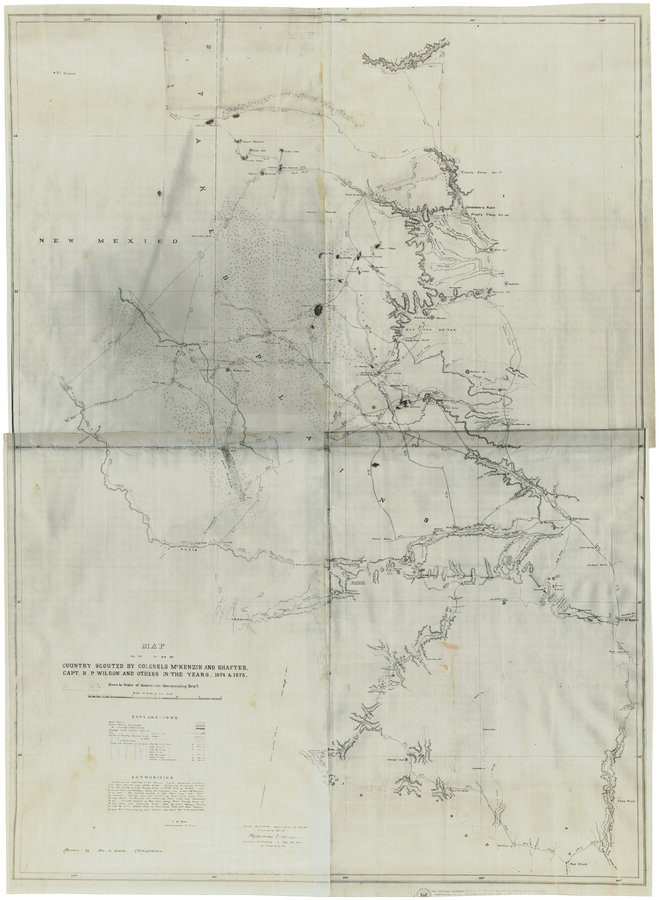
Map of the country scouted by Colonels McKenzie and Shafter, Capt. R.P. Wilson and others in the years, 1874 & 1875
-
Map/Doc
62972
-
Collection
General Map Collection
-
Object Dates
1876 (Creation Date)
-
People and Organizations
T.W. Jones (Military Officer)
Alex L. Lucas (Draftsman)
Herman Schreiver (Military Officer)
-
Subjects
Military
-
Height x Width
43.0 x 31.8 inches
109.2 x 80.8 cm
-
Medium
photostat
-
Scale
8 miles to one inch
-
Features
Ft. Sumner
Laguna Salados
Laguna Tejoneito
Hunt's Lake
Vieles Lakes
Lebo's Lake
Lagunas Casa Amarilla
Laguna Quemado
The Indian Well
Rio Azul
Delaware Creek
Rio Pecos
Toyah Creek
Adobe Walls
Pecos Falls
Leon Creek
Comanche Creek
Fort Stockton
Horsehead Crossing
Escondido Creek
Escondido
Middle Escondido
Little Escondido
Fort Clark
Las Moras Creek
Piedras Creek
Sycamore Creek
Mud Creek
San Felipe
Devils River
Paint Cave Spring
Colladays' Peak
Gasmann's Spring
Maxons Creek
Bedals Creek
Richland Creek
Independence Creek
San Antonio Road
Howard's Well
Bullis Waterhole
Geddes Spring
Mustang Waterholes
Lone Tree Mountain
Main Concho River
Good Spring Creek
Dove Creek
Sterlings Creek
Twin Mountains
Fort Concho
South Concho River
Road to Fort Concho
Round Top Mountain
22 Mile Waterhole
18 Mile Waterhole
13 Mile Waterhole
11 Mile Waterhole
8 Mile Waterhole
Fort McKavett
San Saba River
North Llano River
South Llano River
Camp Wood
East Fork Nueces River
West Fork Nueces River
Kickapoo Spring
Lipan Spring
Vine Creek
North Concho River
Lacey's Prong
Mustang Spring
Baldwins Spring
Five Wells
White Sand Hills
Shafter's Lake
Three Wells
Mountain Spring
McLean's Wells
Seminole Wells
Wards Wells
Rendelbrooks Spring
Girauds Creek
White Spring
Four Mountains
Big Spring
El Infierno
Custers Lake
Laguna Piedra
Ojo Piedra or Sulphur Springs
La Muerte
Arroyo Tabaco
Davis Creek
Hoyt's Creek
Henry's Creek
Boehan's Mt.
Shoemakers Peak
Colorado River
Culver's Creek
Moo-Cha-Ko-Way Mountain
Mount Gunther
Warrington Creek
Dursts Creek
Tyler's Creek
Arroyo Saeno
Cunningham Lake
French's Lakes
Ojo Blanco
Lagunas Cuates
Laguna Ombligo
Laguna Rica
Laguna Tohoko
Mackenzie Mountains
Wood's Peak
Agua de Toro
Leeper's Creek
Double Mountain Fork
White Mountain
Miller's Creek
Haleh's Hill
Fresh Fork of Brazos River
Anderson's Fort
Canon Blanco
Cañon Rescala
Cañon Tule
Staked Plains
Part of: General Map Collection
Blanco County Working Sketch 6

Print $20.00
- Digital $50.00
Blanco County Working Sketch 6
1923
Size 17.6 x 12.5 inches
Map/Doc 67365
Flight Mission No. BRA-6M, Frame 80, Jefferson County

Print $20.00
- Digital $50.00
Flight Mission No. BRA-6M, Frame 80, Jefferson County
1953
Size 18.6 x 22.3 inches
Map/Doc 85424
Map of Lampasas County

Print $20.00
- Digital $50.00
Map of Lampasas County
1864
Size 20.5 x 24.8 inches
Map/Doc 3793
Ochiltree County Sketch File 3

Print $40.00
- Digital $50.00
Ochiltree County Sketch File 3
1908
Size 15.4 x 12.9 inches
Map/Doc 33177
Kerr County Sketch File 12

Print $4.00
- Digital $50.00
Kerr County Sketch File 12
1901
Size 6.7 x 11.1 inches
Map/Doc 28881
Maps of Gulf Intracoastal Waterway, Texas - Sabine River to the Rio Grande and connecting waterways including ship channels

Print $20.00
- Digital $50.00
Maps of Gulf Intracoastal Waterway, Texas - Sabine River to the Rio Grande and connecting waterways including ship channels
1966
Size 14.5 x 22.3 inches
Map/Doc 61923
Liberty County Sketch File 39

Print $4.00
- Digital $50.00
Liberty County Sketch File 39
1872
Size 7.4 x 7.8 inches
Map/Doc 29994
Colorado County Working Sketch 11

Print $3.00
- Digital $50.00
Colorado County Working Sketch 11
1942
Size 10.6 x 16.5 inches
Map/Doc 68111
Runnels County Sketch File 16

Print $20.00
Runnels County Sketch File 16
1879
Size 17.0 x 9.1 inches
Map/Doc 35470
Bexar County Working Sketch 2

Print $20.00
- Digital $50.00
Bexar County Working Sketch 2
1940
Size 24.8 x 27.9 inches
Map/Doc 67318
Hutchinson County Rolled Sketch 37

Print $20.00
- Digital $50.00
Hutchinson County Rolled Sketch 37
1950
Size 24.4 x 44.4 inches
Map/Doc 6296
Presidio County Sketch File 122

Print $22.00
- Digital $50.00
Presidio County Sketch File 122
2010
Size 11.0 x 8.5 inches
Map/Doc 89604
You may also like
K&E Both's Patent Section Liner and Scale Divider #1160

K&E Both's Patent Section Liner and Scale Divider #1160
Size 2.4 x 15.5 inches
Map/Doc 97304
Throckmorton County Boundary File 6

Print $6.00
- Digital $50.00
Throckmorton County Boundary File 6
Size 11.4 x 8.9 inches
Map/Doc 59292
Hudspeth County Sketch File 44

Print $6.00
- Digital $50.00
Hudspeth County Sketch File 44
1886
Size 11.0 x 8.5 inches
Map/Doc 27027
[Map of Nacogdoches County]
![10784, [Map of Nacogdoches County], General Map Collection](https://historictexasmaps.com/wmedia_w700/maps/10784-1.tif.jpg)
Print $40.00
- Digital $50.00
[Map of Nacogdoches County]
1840
Size 79.3 x 69.8 inches
Map/Doc 10784
Map of Harris County

Print $40.00
- Digital $50.00
Map of Harris County
1897
Size 48.4 x 68.5 inches
Map/Doc 82069
Map of Chocolate Bay, west portion of West Bay & vicinity, Brazoria & Galveston Counties showing subdivision for mineral development

Print $40.00
- Digital $50.00
Map of Chocolate Bay, west portion of West Bay & vicinity, Brazoria & Galveston Counties showing subdivision for mineral development
Size 42.0 x 58.1 inches
Map/Doc 65806
Rio Grande Rectification Project, El Paso and Juarez Valley

Print $20.00
- Digital $50.00
Rio Grande Rectification Project, El Paso and Juarez Valley
1935
Size 10.7 x 29.6 inches
Map/Doc 60859
Origin of Exports, Destination of Imports at Texas City, Tex. during 1921

Print $20.00
- Digital $50.00
Origin of Exports, Destination of Imports at Texas City, Tex. during 1921
1921
Size 13.8 x 9.6 inches
Map/Doc 97162


Johnson County Working Sketch 16

Print $20.00
- Digital $50.00
Johnson County Working Sketch 16
1981
Size 37.3 x 38.0 inches
Map/Doc 66629
Crosby County Boundary File 1

Print $20.00
- Digital $50.00
Crosby County Boundary File 1
Size 7.4 x 4.1 inches
Map/Doc 51971