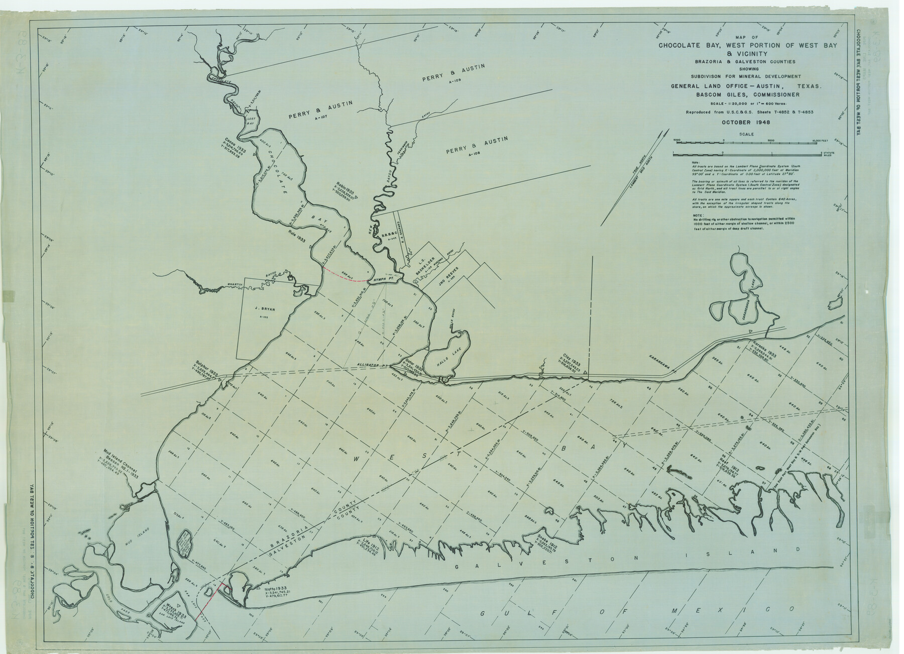
Map of Chocolate Bay, west portion of West Bay & vicinity, Brazoria & Galveston Counties showing subdivision for mineral development
K-3-89
-
Map/Doc
65806
-
Collection
General Map Collection
-
Counties
Brazoria Galveston
-
Subjects
Energy Offshore Submerged Area
-
Height x Width
42.0 x 58.1 inches
106.7 x 147.6 cm
Part of: General Map Collection
Flight Mission No. BQY-15M, Frame 16, Harris County

Print $20.00
- Digital $50.00
Flight Mission No. BQY-15M, Frame 16, Harris County
1953
Size 18.6 x 22.4 inches
Map/Doc 85314
Flight Mission No. BRE-1P, Frame 97, Nueces County

Print $20.00
- Digital $50.00
Flight Mission No. BRE-1P, Frame 97, Nueces County
1956
Size 18.3 x 22.0 inches
Map/Doc 86668
Montgomery County Working Sketch 59

Print $20.00
- Digital $50.00
Montgomery County Working Sketch 59
1962
Size 25.4 x 22.8 inches
Map/Doc 71166
Engineer's Office, Department of the Gulf Map No. 59, Texas prepared by order of Maj. Gen. N. P. Banks under direction of Capt. P. C. Hains, U. S. Engr. & Chief Engr., Dept. of the Gulf

Print $20.00
- Digital $50.00
Engineer's Office, Department of the Gulf Map No. 59, Texas prepared by order of Maj. Gen. N. P. Banks under direction of Capt. P. C. Hains, U. S. Engr. & Chief Engr., Dept. of the Gulf
1865
Size 18.3 x 27.5 inches
Map/Doc 72719
Rusk County Working Sketch 8

Print $20.00
- Digital $50.00
Rusk County Working Sketch 8
1981
Size 22.4 x 20.6 inches
Map/Doc 63643
[Surveys along Seco, Pecan and Deer Creeks]
![316, [Surveys along Seco, Pecan and Deer Creeks], General Map Collection](https://historictexasmaps.com/wmedia_w700/maps/316.tif.jpg)
Print $2.00
- Digital $50.00
[Surveys along Seco, Pecan and Deer Creeks]
1847
Size 8.9 x 7.8 inches
Map/Doc 316
Map of Hale County

Print $20.00
- Digital $50.00
Map of Hale County
1900
Size 47.8 x 38.6 inches
Map/Doc 66847
Dimmit County Working Sketch 27

Print $20.00
- Digital $50.00
Dimmit County Working Sketch 27
1956
Size 20.3 x 23.0 inches
Map/Doc 68688
Brewster County Working Sketch 90

Print $40.00
- Digital $50.00
Brewster County Working Sketch 90
1975
Size 61.0 x 43.3 inches
Map/Doc 67690
Rusk County Sketch File 12

Print $6.00
- Digital $50.00
Rusk County Sketch File 12
1845
Size 8.4 x 7.9 inches
Map/Doc 35511
Jefferson County Sketch File 25

Print $14.00
- Digital $50.00
Jefferson County Sketch File 25
1896
Size 7.6 x 6.7 inches
Map/Doc 28184
Pecos County Rolled Sketch 18

Print $20.00
- Digital $50.00
Pecos County Rolled Sketch 18
1882
Size 34.4 x 44.1 inches
Map/Doc 9683
You may also like
New Map of Texas with the Contiguous American and Mexican States

Print $20.00
New Map of Texas with the Contiguous American and Mexican States
1835
Size 13.3 x 15.9 inches
Map/Doc 88894
Navarro County Working Sketch 1c

Print $2.00
- Digital $50.00
Navarro County Working Sketch 1c
Size 7.1 x 10.6 inches
Map/Doc 71231
Coleman County Rolled Sketch 8

Print $40.00
- Digital $50.00
Coleman County Rolled Sketch 8
1951
Size 58.8 x 40.8 inches
Map/Doc 8634
Flight Mission No. DIX-5P, Frame 145, Aransas County

Print $20.00
- Digital $50.00
Flight Mission No. DIX-5P, Frame 145, Aransas County
1956
Size 17.8 x 18.1 inches
Map/Doc 83806
Northeast Part Presidio County

Print $20.00
- Digital $50.00
Northeast Part Presidio County
1973
Size 42.3 x 33.4 inches
Map/Doc 95616
Amistad International Reservoir on Rio Grande 108

Print $20.00
- Digital $50.00
Amistad International Reservoir on Rio Grande 108
1950
Size 28.5 x 40.9 inches
Map/Doc 75539
Denton County Sketch File 22

Print $4.00
- Digital $50.00
Denton County Sketch File 22
1872
Size 8.5 x 16.0 inches
Map/Doc 20746
[Sketch showing C. D. & W. A. Murphy's Pasture and Wint Barfield's Pasture]
![90935, [Sketch showing C. D. & W. A. Murphy's Pasture and Wint Barfield's Pasture], Twichell Survey Records](https://historictexasmaps.com/wmedia_w700/maps/90935-1.tif.jpg)
Print $20.00
- Digital $50.00
[Sketch showing C. D. & W. A. Murphy's Pasture and Wint Barfield's Pasture]
Size 30.4 x 26.7 inches
Map/Doc 90935
Kleberg County Aerial Photograph Index Sheet 5

Print $20.00
- Digital $50.00
Kleberg County Aerial Photograph Index Sheet 5
1956
Size 19.5 x 23.5 inches
Map/Doc 83722
[Sketch for Mineral Application 24072, San Jacinto River]
![65599, [Sketch for Mineral Application 24072, San Jacinto River], General Map Collection](https://historictexasmaps.com/wmedia_w700/maps/65599.tif.jpg)
Print $20.00
- Digital $50.00
[Sketch for Mineral Application 24072, San Jacinto River]
1929
Size 23.5 x 18.0 inches
Map/Doc 65599
[Map of Line Dividing Fannin and Nacogdoches Districts]
![81919, [Map of Line Dividing Fannin and Nacogdoches Districts], General Map Collection](https://historictexasmaps.com/wmedia_w700/maps/81919-1.tif.jpg)
Print $2.00
- Digital $50.00
[Map of Line Dividing Fannin and Nacogdoches Districts]
1850
Size 11.0 x 8.6 inches
Map/Doc 81919
Flight Mission No. DAG-21K, Frame 28, Matagorda County

Print $20.00
- Digital $50.00
Flight Mission No. DAG-21K, Frame 28, Matagorda County
1952
Size 18.6 x 22.4 inches
Map/Doc 86395