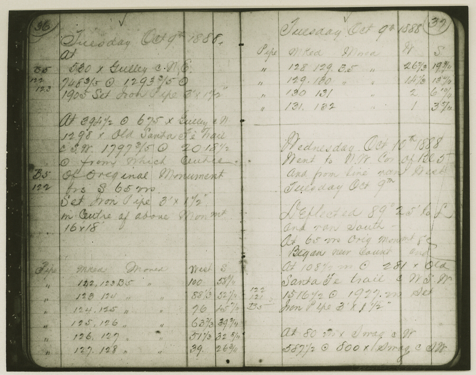
Copy of Surveyor's Field Book, Morris Browning - In Blocks 7, 5 & 4, I&GNRRCo., Hutchinson and Carson Counties, Texas
K-7-70
-
Map/Doc
62279
-
Collection
General Map Collection
-
Object Dates
1888/10/22 (Creation Date)
-
People and Organizations
Morris Browning (Surveyor/Engineer)
-
Counties
Hutchinson Carson
-
Height x Width
7.0 x 8.8 inches
17.8 x 22.4 cm
-
Comments
Copy of Surveyor's field book presented to the General Land Office by Morris Browning on February 3, 1941.
Surveyed from September 14, 1888 to October 22, 1888.
Part of: General Map Collection
Parker County Sketch File C

Print $4.00
- Digital $50.00
Parker County Sketch File C
1857
Size 6.1 x 7.8 inches
Map/Doc 33512
Flight Mission No. DCL-6C, Frame 2, Kenedy County

Print $20.00
- Digital $50.00
Flight Mission No. DCL-6C, Frame 2, Kenedy County
1943
Size 18.6 x 22.4 inches
Map/Doc 85862
Terrell County Working Sketch 19

Print $20.00
- Digital $50.00
Terrell County Working Sketch 19
1932
Size 18.8 x 25.7 inches
Map/Doc 62169
Cochran County Boundary File 1

Print $108.00
- Digital $50.00
Cochran County Boundary File 1
Size 15.4 x 8.7 inches
Map/Doc 51445
Map Showing Location of Galveston, Harrisburg & San Antonio Railway

Print $40.00
- Digital $50.00
Map Showing Location of Galveston, Harrisburg & San Antonio Railway
1881
Size 17.4 x 59.3 inches
Map/Doc 64457
Live Oak County Sketch File 31

Print $30.00
- Digital $50.00
Live Oak County Sketch File 31
1935
Size 36.0 x 32.5 inches
Map/Doc 10528
Motley County Sketch File 3 (N)

Print $22.00
- Digital $50.00
Motley County Sketch File 3 (N)
Size 9.1 x 13.0 inches
Map/Doc 31998
Travis County Boundary File 31

Print $4.00
- Digital $50.00
Travis County Boundary File 31
Size 10.0 x 8.2 inches
Map/Doc 59471
Texas State Boundary Line 9

Print $174.00
Texas State Boundary Line 9
2000
Size 11.3 x 8.8 inches
Map/Doc 75076
Travis County Sketch File 63

Print $14.00
- Digital $50.00
Travis County Sketch File 63
Size 13.5 x 9.2 inches
Map/Doc 38431
Potter County Working Sketch 8

Print $40.00
- Digital $50.00
Potter County Working Sketch 8
1961
Size 68.7 x 37.2 inches
Map/Doc 71668
McLennan County Sketch File 3

Print $4.00
- Digital $50.00
McLennan County Sketch File 3
1857
Size 11.1 x 8.1 inches
Map/Doc 31233
You may also like
Menard County Rolled Sketch 7

Print $20.00
- Digital $50.00
Menard County Rolled Sketch 7
Size 43.2 x 37.3 inches
Map/Doc 9509
Jefferson County Rolled Sketch 59

Print $40.00
- Digital $50.00
Jefferson County Rolled Sketch 59
1898
Size 30.0 x 59.4 inches
Map/Doc 9313
Austin County Boundary File 4

Print $10.00
- Digital $50.00
Austin County Boundary File 4
Size 14.1 x 8.6 inches
Map/Doc 50244
The United States

Print $20.00
- Digital $50.00
The United States
1902
Size 21.4 x 28.4 inches
Map/Doc 95858
Webb County Sketch File 8a

Print $4.00
- Digital $50.00
Webb County Sketch File 8a
Size 7.9 x 8.7 inches
Map/Doc 39743
Cochran and Yoakum Counties, Texas

Print $20.00
- Digital $50.00
Cochran and Yoakum Counties, Texas
1945
Size 24.4 x 17.4 inches
Map/Doc 92513
Parker County Sketch File 4

Print $6.00
- Digital $50.00
Parker County Sketch File 4
1856
Size 6.2 x 5.8 inches
Map/Doc 33525
Jack County Sketch File 14

Print $8.00
- Digital $50.00
Jack County Sketch File 14
1857
Size 10.0 x 5.7 inches
Map/Doc 27539
[Surveys in the Bexar District along the Atascosa Creek]
![221, [Surveys in the Bexar District along the Atascosa Creek], General Map Collection](https://historictexasmaps.com/wmedia_w700/maps/221.tif.jpg)
Print $2.00
- Digital $50.00
[Surveys in the Bexar District along the Atascosa Creek]
1842
Size 5.9 x 5.9 inches
Map/Doc 221
Anderson County Working Sketch 11

Print $40.00
- Digital $50.00
Anderson County Working Sketch 11
1933
Size 42.8 x 57.9 inches
Map/Doc 67010
Flight Mission No. DQO-7K, Frame 104, Galveston County

Print $20.00
- Digital $50.00
Flight Mission No. DQO-7K, Frame 104, Galveston County
1952
Size 18.7 x 22.4 inches
Map/Doc 85119
Oldham County Rolled Sketch 2A

Print $40.00
- Digital $50.00
Oldham County Rolled Sketch 2A
1886
Size 35.9 x 55.6 inches
Map/Doc 9640