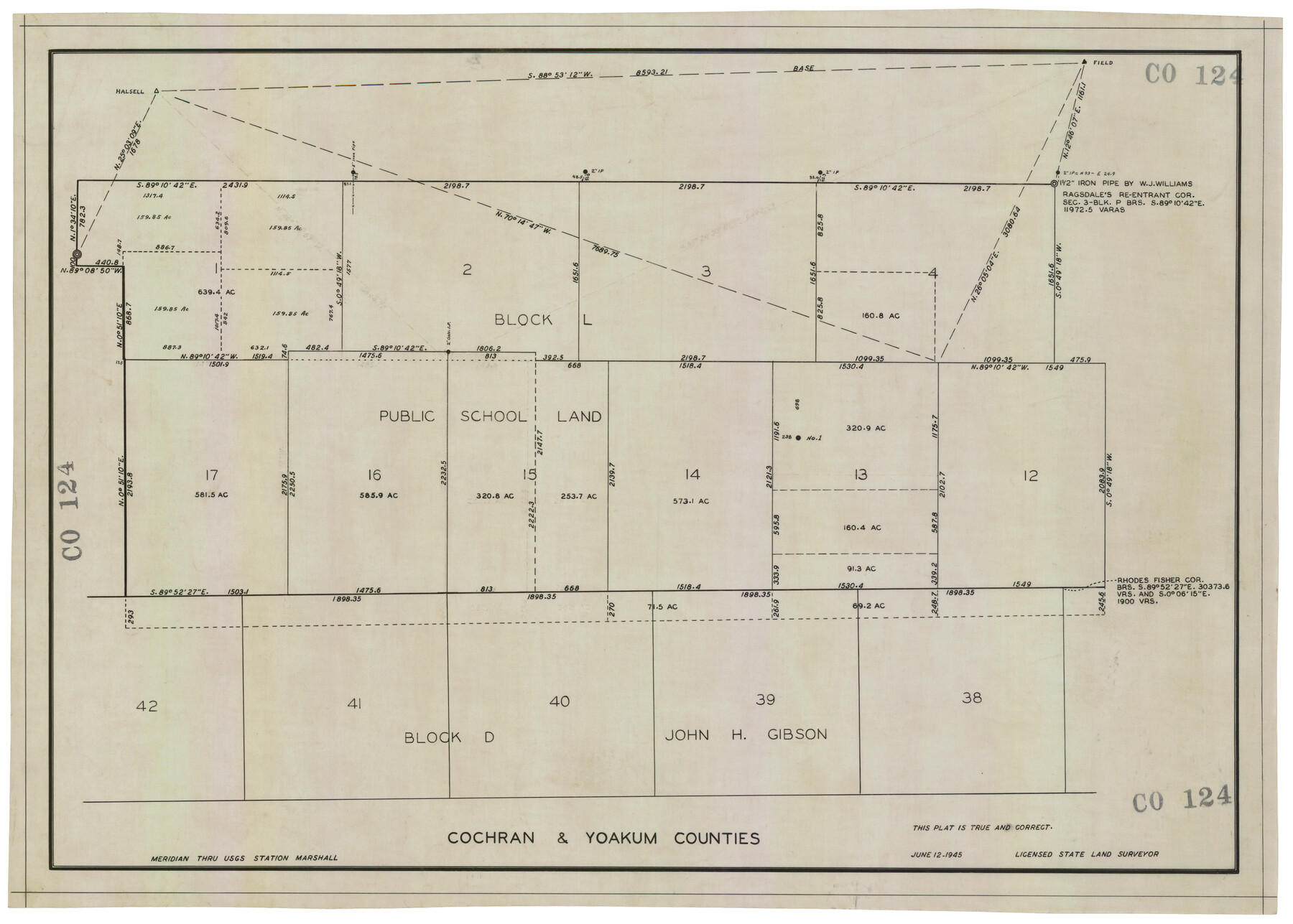
Cochran and Yoakum Counties, Texas
CO124
-
Map/Doc
92513
-
Collection
Twichell Survey Records
-
Object Dates
6/12/1945 (Creation Date)
-
Counties
Cochran Yoakum
-
Height x Width
24.4 x 17.4 inches
62.0 x 44.2 cm
Part of: Twichell Survey Records
Resurvey of the Original Townsite of Sundown Hockley County, Texas

Print $20.00
- Digital $50.00
Resurvey of the Original Townsite of Sundown Hockley County, Texas
Size 21.7 x 40.3 inches
Map/Doc 92234
General Highway Map, Yoakum County Texas

Print $20.00
- Digital $50.00
General Highway Map, Yoakum County Texas
1952
Size 26.3 x 19.1 inches
Map/Doc 92815
John N. Jane's Subdivision of Sterling County School Lands Lamb County, Texas

Print $20.00
- Digital $50.00
John N. Jane's Subdivision of Sterling County School Lands Lamb County, Texas
Size 19.9 x 23.0 inches
Map/Doc 92179
[Sketch showing School Lands]
![90449, [Sketch showing School Lands], Twichell Survey Records](https://historictexasmaps.com/wmedia_w700/maps/90449-1.tif.jpg)
Print $20.00
- Digital $50.00
[Sketch showing School Lands]
Size 25.4 x 12.5 inches
Map/Doc 90449
[Sketch showing surveys in Blocks 70, 71 and 72 surrounding the town of Toyah]
![91835, [Sketch showing surveys in Blocks 70, 71 and 72 surrounding the town of Toyah], Twichell Survey Records](https://historictexasmaps.com/wmedia_w700/maps/91835-1.tif.jpg)
Print $20.00
- Digital $50.00
[Sketch showing surveys in Blocks 70, 71 and 72 surrounding the town of Toyah]
Size 44.1 x 24.0 inches
Map/Doc 91835
[Southeast part of Block D and Blocks DD, C31-C37, AX, G and H]
![92012, [Southeast part of Block D and Blocks DD, C31-C37, AX, G and H], Twichell Survey Records](https://historictexasmaps.com/wmedia_w700/maps/92012-1.tif.jpg)
Print $20.00
- Digital $50.00
[Southeast part of Block D and Blocks DD, C31-C37, AX, G and H]
Size 21.4 x 15.0 inches
Map/Doc 92012
Lakeview Addition to the City of Shallowater out of the Southeast 1/4 of Section 27, Block D5

Print $3.00
- Digital $50.00
Lakeview Addition to the City of Shallowater out of the Southeast 1/4 of Section 27, Block D5
1955
Size 17.9 x 11.6 inches
Map/Doc 92870
[1680 Bed of Rock 20 Feet in Diameter on East Bank of Concho Drain]
![91361, [1680 Bed of Rock 20 Feet in Diameter on East Bank of Concho Drain], Twichell Survey Records](https://historictexasmaps.com/wmedia_w700/maps/91361-1.tif.jpg)
Print $20.00
- Digital $50.00
[1680 Bed of Rock 20 Feet in Diameter on East Bank of Concho Drain]
Size 25.4 x 15.1 inches
Map/Doc 91361
Map of Independence Area, Washington County, Texas

Print $20.00
- Digital $50.00
Map of Independence Area, Washington County, Texas
1935
Size 24.0 x 19.1 inches
Map/Doc 91989
[Sketch showing Block 47, sections 77-108]
![91732, [Sketch showing Block 47, sections 77-108], Twichell Survey Records](https://historictexasmaps.com/wmedia_w700/maps/91732-1.tif.jpg)
Print $20.00
- Digital $50.00
[Sketch showing Block 47, sections 77-108]
1919
Size 20.5 x 34.1 inches
Map/Doc 91732
Capitol Syndicate Subdivision of Capitol Land Reservation Leagues

Print $20.00
- Digital $50.00
Capitol Syndicate Subdivision of Capitol Land Reservation Leagues
1908
Size 25.6 x 31.5 inches
Map/Doc 92584
Sketch Showing Boundary Between Randall and Deaf Smith Counties

Print $20.00
- Digital $50.00
Sketch Showing Boundary Between Randall and Deaf Smith Counties
Size 13.4 x 33.3 inches
Map/Doc 91832
You may also like
Brooks County Working Sketch 18

Print $20.00
- Digital $50.00
Brooks County Working Sketch 18
1981
Size 20.6 x 32.4 inches
Map/Doc 67802
Flight Mission No. BRE-1P, Frame 125, Nueces County

Print $20.00
- Digital $50.00
Flight Mission No. BRE-1P, Frame 125, Nueces County
1956
Size 18.6 x 22.7 inches
Map/Doc 86691
St. Louis Southwestern Railway of Texas

Print $20.00
- Digital $50.00
St. Louis Southwestern Railway of Texas
1906
Size 21.4 x 30.0 inches
Map/Doc 64450
Cameron County Sketch File 3

Print $42.00
- Digital $50.00
Cameron County Sketch File 3
1930
Size 11.1 x 8.8 inches
Map/Doc 17023
Maps & Lists Showing Prison Lands (Oil & Gas) Leased as of June 1955

Digital $50.00
Maps & Lists Showing Prison Lands (Oil & Gas) Leased as of June 1955
1934
Size 29.6 x 38.1 inches
Map/Doc 62880
Frio County Sketch File 19

Print $20.00
- Digital $50.00
Frio County Sketch File 19
1963
Size 14.7 x 30.6 inches
Map/Doc 11519
Karte des Staates, Texas

Print $20.00
- Digital $50.00
Karte des Staates, Texas
1851
Size 25.5 x 30.8 inches
Map/Doc 2123
Maps of Gulf Intracoastal Waterway, Texas - Sabine River to the Rio Grande and connecting waterways including ship channels

Print $20.00
- Digital $50.00
Maps of Gulf Intracoastal Waterway, Texas - Sabine River to the Rio Grande and connecting waterways including ship channels
1966
Size 14.6 x 22.2 inches
Map/Doc 61947
Orange County Sketch File 12

Print $4.00
- Digital $50.00
Orange County Sketch File 12
1876
Size 12.7 x 7.9 inches
Map/Doc 33324
[Corpus Christi & Rio Grande Certificates]
![64492, [Corpus Christi & Rio Grande Certificates], General Map Collection](https://historictexasmaps.com/wmedia_w700/pdf_converted_jpg/qi_pdf_thumbnail_19225.jpg)
Print $16.00
- Digital $50.00
[Corpus Christi & Rio Grande Certificates]
1874
Size 14.3 x 8.7 inches
Map/Doc 64492

McMullen County Working Sketch 52

Print $20.00
- Digital $50.00
McMullen County Working Sketch 52
1983
Size 18.0 x 19.4 inches
Map/Doc 70753