Oldham County Rolled Sketch 2A
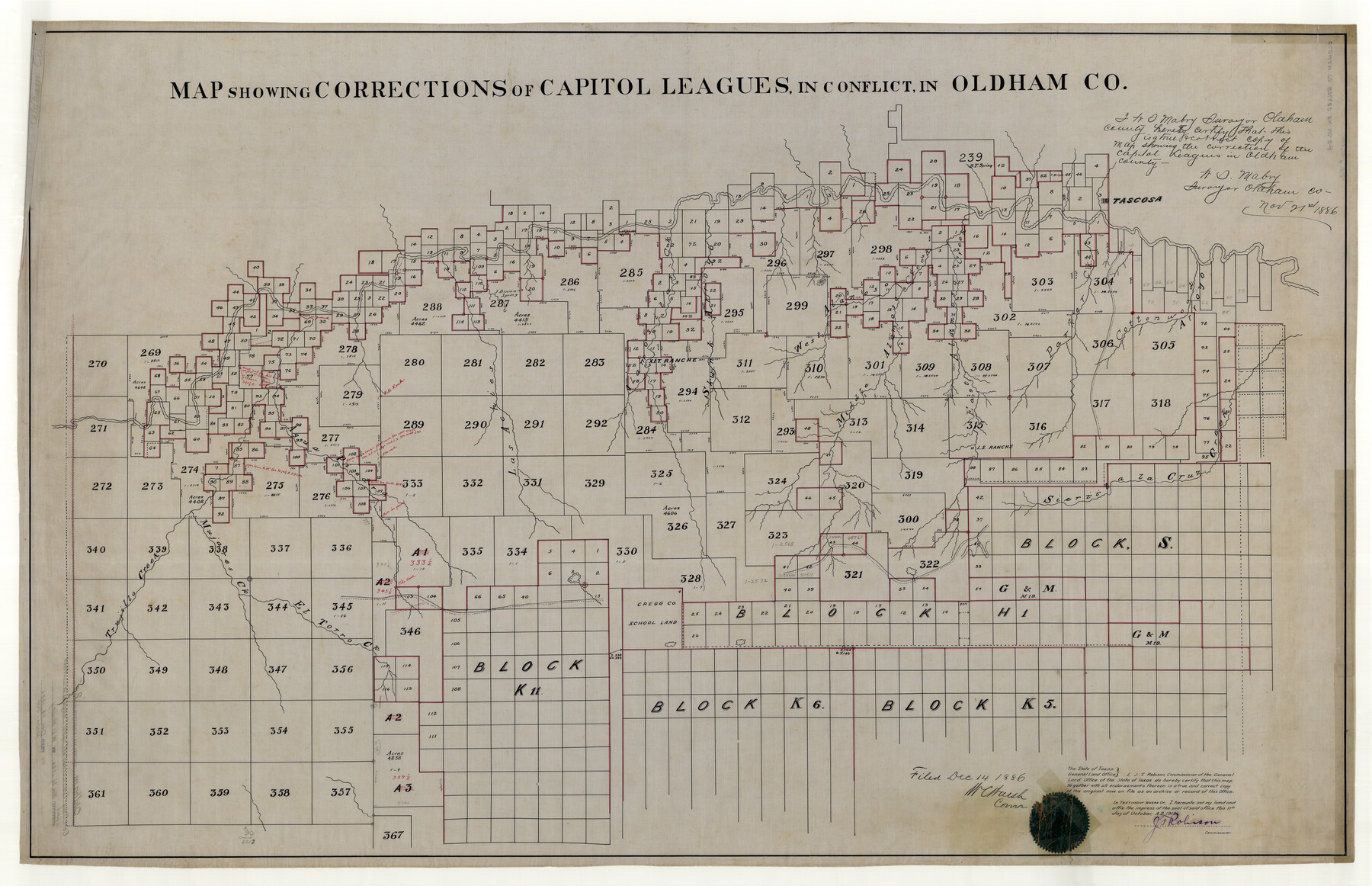
Map showing corrections of Capitol Leagues in conflict in Oldham Co.
-
Map/Doc
9640
-
Collection
General Map Collection
-
Object Dates
11/21/1886 (Creation Date)
12/14/1886 (File Date)
10/11/1919 (Copy/Tracing Date)
-
People and Organizations
W.D. Mabry (Surveyor/Engineer)
J.T. Robison (GLO Commissioner)
-
Counties
Oldham
-
Subjects
Surveying Rolled Sketch
-
Height x Width
35.9 x 55.6 inches
91.2 x 141.2 cm
-
Medium
map tracing
-
Materials
linen
-
Comments
Certified copy of original - map 9639
Related maps
Oldham County Rolled Sketch 2

Print $40.00
- Digital $50.00
Oldham County Rolled Sketch 2
1886
Size 35.7 x 55.1 inches
Map/Doc 9639
Part of: General Map Collection
Zavala County

Print $40.00
- Digital $50.00
Zavala County
1977
Size 43.9 x 49.2 inches
Map/Doc 73334
Texas & Pacific R. R. through Pecos-Presidio Counties

Print $40.00
- Digital $50.00
Texas & Pacific R. R. through Pecos-Presidio Counties
Size 20.3 x 70.7 inches
Map/Doc 64282
Armstrong County Working Sketch 2

Print $20.00
- Digital $50.00
Armstrong County Working Sketch 2
1904
Size 29.0 x 23.4 inches
Map/Doc 67233

Terry County Sketch File 17

Print $5.00
- Digital $50.00
Terry County Sketch File 17
1956
Size 27.7 x 24.7 inches
Map/Doc 12429

Upton County Sketch File 26

Print $20.00
- Digital $50.00
Upton County Sketch File 26
1928
Size 22.6 x 14.2 inches
Map/Doc 12520
San Patricio County NRC Article 33.136 Sketch 3

Print $3.00
- Digital $50.00
San Patricio County NRC Article 33.136 Sketch 3
Size 17.0 x 11.0 inches
Map/Doc 94694
Parker County Rolled Sketch 4

Print $20.00
- Digital $50.00
Parker County Rolled Sketch 4
Size 28.0 x 34.1 inches
Map/Doc 7205
Reeves County Sketch File 1

Print $10.00
- Digital $50.00
Reeves County Sketch File 1
Size 9.0 x 15.8 inches
Map/Doc 35176
Boundary and Ownership map, Laguna Atascosa National Wildlife Refuge, Cameron and Willacy Counties, Texas

Print $40.00
- Digital $50.00
Boundary and Ownership map, Laguna Atascosa National Wildlife Refuge, Cameron and Willacy Counties, Texas
1968
Size 73.1 x 43.0 inches
Map/Doc 60394
Marion County Working Sketch 1

Print $20.00
- Digital $50.00
Marion County Working Sketch 1
Size 15.2 x 23.3 inches
Map/Doc 70776
You may also like
Milam County Boundary File 6a

Print $20.00
- Digital $50.00
Milam County Boundary File 6a
Size 9.5 x 29.0 inches
Map/Doc 57248
Travis County Sketch File 47

Print $6.00
- Digital $50.00
Travis County Sketch File 47
1939
Size 14.3 x 8.9 inches
Map/Doc 38374
Crosby County Sketch File 13a

Print $44.00
- Digital $50.00
Crosby County Sketch File 13a
1903
Size 8.8 x 4.5 inches
Map/Doc 20036
New Map of State of Texas

Print $20.00
- Digital $50.00
New Map of State of Texas
1881
Size 21.4 x 27.6 inches
Map/Doc 460
Flight Mission No. BQR-3K, Frame 155, Brazoria County

Print $20.00
- Digital $50.00
Flight Mission No. BQR-3K, Frame 155, Brazoria County
1952
Size 18.7 x 22.4 inches
Map/Doc 83982
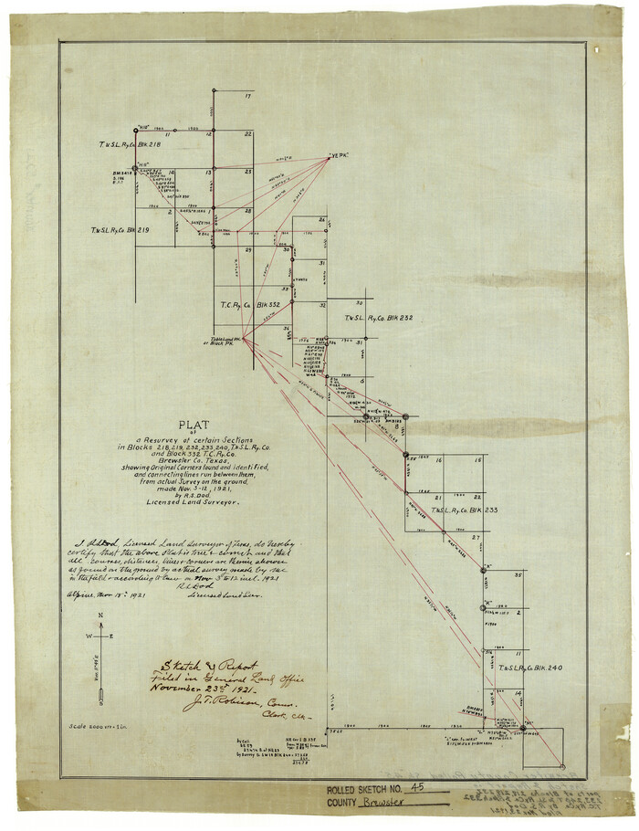
Brewster County Rolled Sketch 45
Print $20.00
- Digital $50.00
Brewster County Rolled Sketch 45
1921
Size 20.3 x 15.6 inches
Map/Doc 5221
Shelby County Rolled Sketch 3

Print $40.00
- Digital $50.00
Shelby County Rolled Sketch 3
Size 54.2 x 37.0 inches
Map/Doc 9919
El Paso County Sketch File 41

Print $6.00
- Digital $50.00
El Paso County Sketch File 41
1994
Size 11.4 x 8.8 inches
Map/Doc 22238
Gregg County Rolled Sketch 25

Print $40.00
- Digital $50.00
Gregg County Rolled Sketch 25
1933
Size 27.3 x 51.7 inches
Map/Doc 9076
Bexar County Sketch File 9

Print $4.00
- Digital $50.00
Bexar County Sketch File 9
1853
Size 8.2 x 13.2 inches
Map/Doc 14479
Gray County Sketch File B3

Print $8.00
- Digital $50.00
Gray County Sketch File B3
1880
Size 13.0 x 8.5 inches
Map/Doc 24411
Fayette County Boundary File 5

Print $59.00
- Digital $50.00
Fayette County Boundary File 5
Size 14.4 x 9.0 inches
Map/Doc 53371