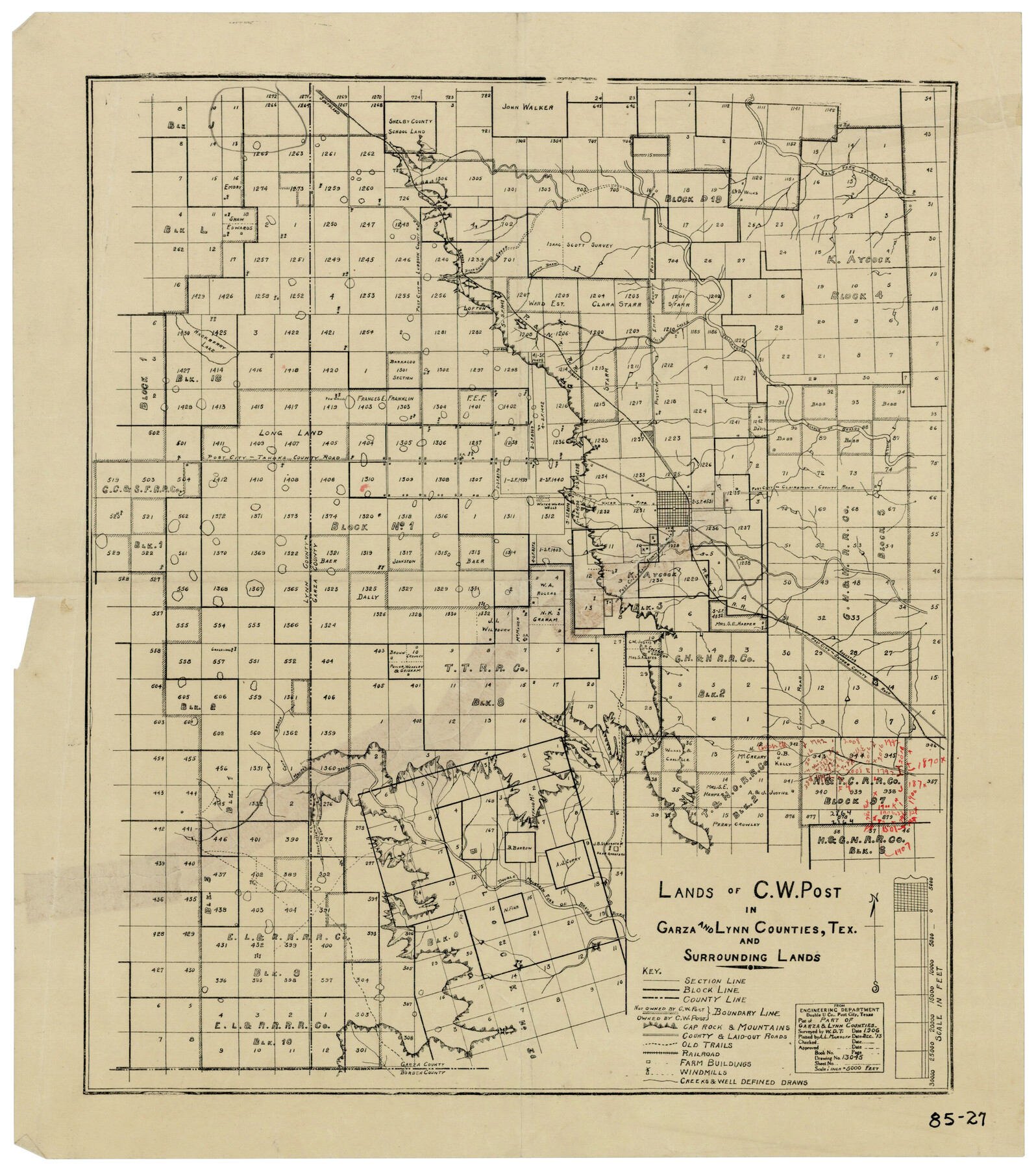
Lands of C. W. Post in Garza and Lynn Counties, Tex. and Surrounding Lands
85-27
-
Map/Doc
90851
-
Collection
Twichell Survey Records
-
Object Dates
12/1913 (Creation Date)
-
People and Organizations
Double U Co. (Publisher)
W.D. Twichell (Surveyor/Engineer)
-
Counties
Garza Lynn
-
Height x Width
15.8 x 18.0 inches
40.1 x 45.7 cm
Part of: Twichell Survey Records

[Surrounding McCrummens Second Addition]
![92839, [Surrounding McCrummens Second Addition], Twichell Survey Records](https://historictexasmaps.com/wmedia_w700/maps/92839-1.tif.jpg)
Print $20.00
- Digital $50.00
[Surrounding McCrummens Second Addition]
Size 31.2 x 33.1 inches
Map/Doc 92839
![92953, [Terry County], Twichell Survey Records](https://historictexasmaps.com/wmedia_w700/maps/92953-1.tif.jpg)
[Part of Block JK4 and A1]
![90784, [Part of Block JK4 and A1], Twichell Survey Records](https://historictexasmaps.com/wmedia_w700/maps/90784-1.tif.jpg)
Print $3.00
- Digital $50.00
[Part of Block JK4 and A1]
Size 17.0 x 11.2 inches
Map/Doc 90784
[Lgs. 195-199, 111, 112, 211-214, 678]
![90105, [Lgs. 195-199, 111, 112, 211-214, 678], Twichell Survey Records](https://historictexasmaps.com/wmedia_w700/maps/90105-1.tif.jpg)
Print $20.00
- Digital $50.00
[Lgs. 195-199, 111, 112, 211-214, 678]
Size 16.6 x 13.0 inches
Map/Doc 90105
[Area south of University Block 16, Block O and PSL Block N]
![91951, [Area south of University Block 16, Block O and PSL Block N], Twichell Survey Records](https://historictexasmaps.com/wmedia_w700/maps/91951-1.tif.jpg)
Print $20.00
- Digital $50.00
[Area south of University Block 16, Block O and PSL Block N]
Size 21.9 x 24.0 inches
Map/Doc 91951

[Crocket County School Land along Bailey and Lamb County Line]
![90197, [Crocket County School Land along Bailey and Lamb County Line], Twichell Survey Records](https://historictexasmaps.com/wmedia_w700/maps/90197-1.tif.jpg)
Print $20.00
- Digital $50.00
[Crocket County School Land along Bailey and Lamb County Line]
Size 26.8 x 18.9 inches
Map/Doc 90197
Reeves County

Print $20.00
- Digital $50.00
Reeves County
1915
Size 23.6 x 29.8 inches
Map/Doc 92896
[I. & G. N. Block 1, Runnels County School Land and adjacent areas]
![91615, [I. & G. N. Block 1, Runnels County School Land and adjacent areas], Twichell Survey Records](https://historictexasmaps.com/wmedia_w700/maps/91615-1.tif.jpg)
Print $20.00
- Digital $50.00
[I. & G. N. Block 1, Runnels County School Land and adjacent areas]
Size 34.2 x 28.0 inches
Map/Doc 91615
John B. Slaughter Ranch Situated in Garza County, Texas

Print $20.00
- Digital $50.00
John B. Slaughter Ranch Situated in Garza County, Texas
Size 32.5 x 44.7 inches
Map/Doc 92657
[Area to the West and North of the Abraham Winfrey survey 11]
![90222, [Area to the West and North of the Abraham Winfrey survey 11], Twichell Survey Records](https://historictexasmaps.com/wmedia_w700/maps/90222-1.tif.jpg)
Print $20.00
- Digital $50.00
[Area to the West and North of the Abraham Winfrey survey 11]
1920
Size 25.7 x 22.5 inches
Map/Doc 90222
You may also like
Map of subdivision of submerged land in the Gulf of Mexico fronting on Matagorda Island and Peninsula

Print $40.00
- Digital $50.00
Map of subdivision of submerged land in the Gulf of Mexico fronting on Matagorda Island and Peninsula
1940
Size 28.3 x 60.5 inches
Map/Doc 2928
Mitchell County Working Sketch Graphic Index

Print $20.00
- Digital $50.00
Mitchell County Working Sketch Graphic Index
1971
Size 41.0 x 34.4 inches
Map/Doc 76644
Texas Intracoastal Waterway, Aransas Bay to Aransas Pass

Print $20.00
- Digital $50.00
Texas Intracoastal Waterway, Aransas Bay to Aransas Pass
1962
Size 38.7 x 26.8 inches
Map/Doc 73439
[Unknown Building Sketch]
![75793, [Unknown Building Sketch], Maddox Collection](https://historictexasmaps.com/wmedia_w700/maps/75793.tif.jpg)
Print $20.00
- Digital $50.00
[Unknown Building Sketch]
Size 15.3 x 23.0 inches
Map/Doc 75793
Harris County Working Sketch 19

Print $40.00
- Digital $50.00
Harris County Working Sketch 19
1921
Size 42.5 x 55.0 inches
Map/Doc 65911
Flight Mission No. DQO-8K, Frame 141, Galveston County

Print $20.00
- Digital $50.00
Flight Mission No. DQO-8K, Frame 141, Galveston County
1952
Size 18.6 x 22.4 inches
Map/Doc 85203
Sulphur River, Ringo Crossing Sheet

Print $20.00
- Digital $50.00
Sulphur River, Ringo Crossing Sheet
1933
Size 18.5 x 20.4 inches
Map/Doc 78334
Stonewall County Sketch File 21

Print $4.00
- Digital $50.00
Stonewall County Sketch File 21
1933
Size 7.1 x 8.7 inches
Map/Doc 37291
Flight Mission No. BQY-15M, Frame 13, Harris County

Print $20.00
- Digital $50.00
Flight Mission No. BQY-15M, Frame 13, Harris County
1953
Size 18.8 x 22.5 inches
Map/Doc 85311
Lampasas County Sketch File 3

Print $4.00
- Digital $50.00
Lampasas County Sketch File 3
1856
Size 12.1 x 7.6 inches
Map/Doc 29392
Glasscock County Sketch File 25

Print $20.00
- Digital $50.00
Glasscock County Sketch File 25
1951
Size 28.8 x 20.6 inches
Map/Doc 11566
Aransas Pass to Baffin Bay

Print $20.00
- Digital $50.00
Aransas Pass to Baffin Bay
1922
Size 18.6 x 27.8 inches
Map/Doc 73409