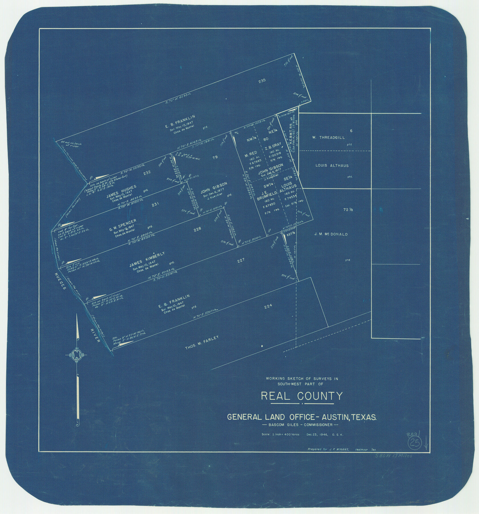
Real County Working Sketch 25
-
Map/Doc
71917
-
Collection
General Map Collection
-
Object Dates
12/23/1946 (Creation Date)
-
People and Organizations
Otto G. Kurio (Draftsman)
-
Counties
Real
-
Subjects
Surveying Working Sketch
-
Height x Width
26.5 x 24.7 inches
67.3 x 62.7 cm
-
Scale
1" = 400 varas
Part of: General Map Collection
Map of Chicago, Rock Island & Texas Railroad

Print $40.00
- Digital $50.00
Map of Chicago, Rock Island & Texas Railroad
1892
Size 23.9 x 122.0 inches
Map/Doc 64442
Wilson County Working Sketch 7

Print $20.00
- Digital $50.00
Wilson County Working Sketch 7
1965
Size 23.7 x 30.2 inches
Map/Doc 72587
Concho County Rolled Sketch 4

Print $20.00
- Digital $50.00
Concho County Rolled Sketch 4
1948
Size 47.3 x 43.6 inches
Map/Doc 8649
McMullen County Working Sketch 14

Print $20.00
- Digital $50.00
McMullen County Working Sketch 14
1938
Size 28.6 x 37.1 inches
Map/Doc 70715
Throckmorton County Rolled Sketch 2

Print $20.00
- Digital $50.00
Throckmorton County Rolled Sketch 2
Size 28.9 x 36.3 inches
Map/Doc 7985
Hamilton County Working Sketch 3

Print $20.00
- Digital $50.00
Hamilton County Working Sketch 3
1926
Size 29.6 x 39.6 inches
Map/Doc 63341
Brazoria County Sketch File 26

Print $40.00
- Digital $50.00
Brazoria County Sketch File 26
Size 13.6 x 13.6 inches
Map/Doc 15028

Stephens County Sketch File 10b

Print $8.00
- Digital $50.00
Stephens County Sketch File 10b
1890
Size 8.5 x 7.8 inches
Map/Doc 37048
Atascosa County Working Sketch 2

Print $20.00
- Digital $50.00
Atascosa County Working Sketch 2
1910
Size 23.5 x 33.2 inches
Map/Doc 67197
Flight Mission No. DCL-7C, Frame 143, Kenedy County

Print $20.00
- Digital $50.00
Flight Mission No. DCL-7C, Frame 143, Kenedy County
1943
Size 18.6 x 22.3 inches
Map/Doc 86100
Somervell County Rolled Sketch A

Print $20.00
- Digital $50.00
Somervell County Rolled Sketch A
Size 14.8 x 15.2 inches
Map/Doc 75999
You may also like
Knox County Boundary File 6

Print $4.00
- Digital $50.00
Knox County Boundary File 6
Size 11.4 x 8.7 inches
Map/Doc 65049
Working Sketch in Kaufman County

Print $40.00
- Digital $50.00
Working Sketch in Kaufman County
1922
Size 36.5 x 52.2 inches
Map/Doc 89702


Val Verde County Working Sketch 50

Print $20.00
- Digital $50.00
Val Verde County Working Sketch 50
1950
Size 27.9 x 28.0 inches
Map/Doc 72185
Map of Lipscomb County

Print $20.00
- Digital $50.00
Map of Lipscomb County
1899
Size 43.9 x 38.9 inches
Map/Doc 78406
Ward County Rolled Sketch 24F

Print $40.00
- Digital $50.00
Ward County Rolled Sketch 24F
1967
Size 43.0 x 72.4 inches
Map/Doc 10117
Cass County Working Sketch 18

Print $20.00
- Digital $50.00
Cass County Working Sketch 18
1958
Size 24.2 x 44.3 inches
Map/Doc 67921
Sketch Showing Portion of League 4, Wilson County School Land in Lynn County

Print $20.00
- Digital $50.00
Sketch Showing Portion of League 4, Wilson County School Land in Lynn County
Size 20.9 x 22.6 inches
Map/Doc 92941
Presidio County Sketch File 64

Print $20.00
- Digital $50.00
Presidio County Sketch File 64
1938
Size 16.5 x 26.5 inches
Map/Doc 11719
Matagorda County Sketch File 9

Print $7.00
- Digital $50.00
Matagorda County Sketch File 9
1877
Size 10.1 x 8.1 inches
Map/Doc 30752
McMullen County Working Sketch 36

Print $20.00
- Digital $50.00
McMullen County Working Sketch 36
1963
Size 40.1 x 41.5 inches
Map/Doc 70737