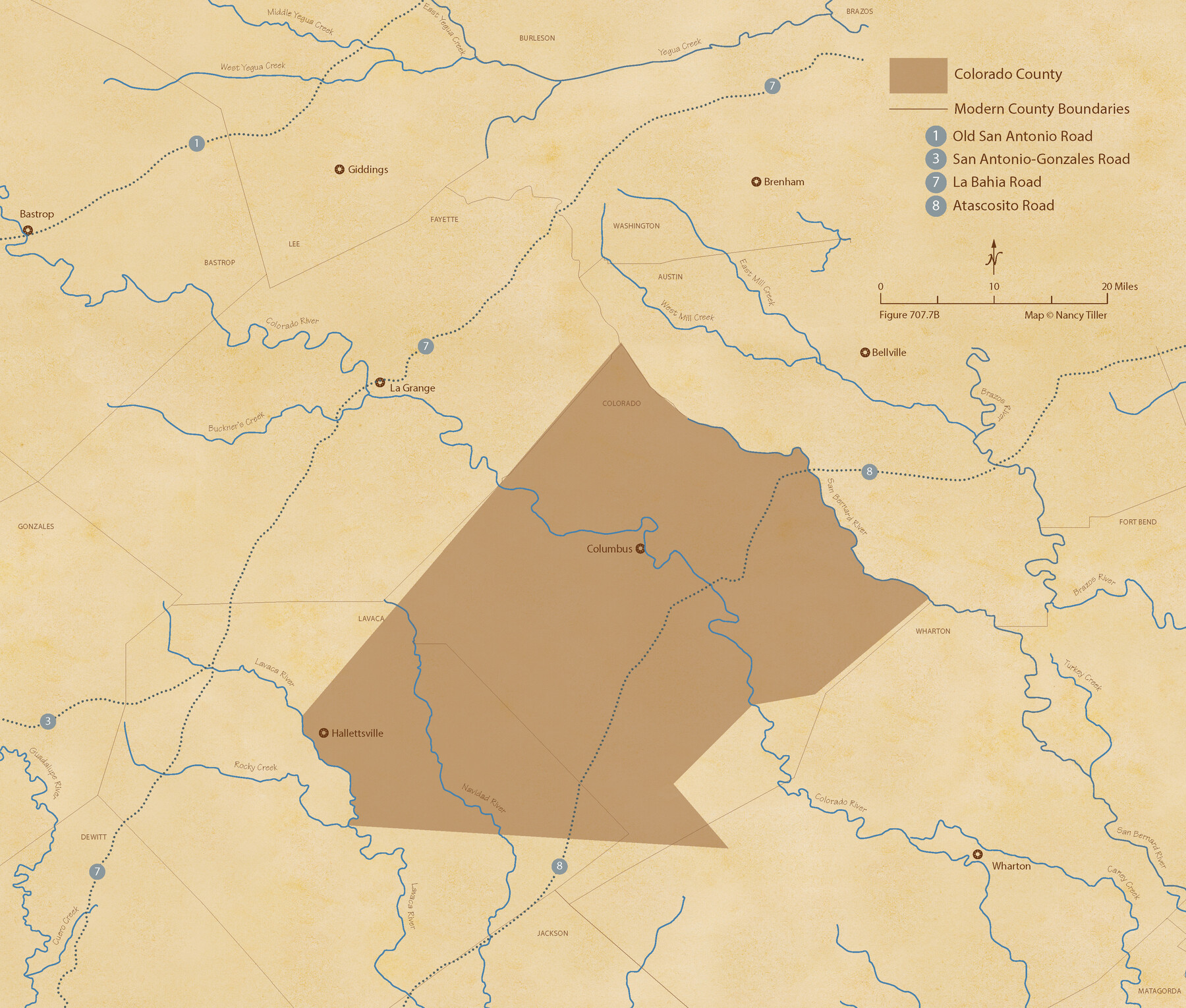
The Republic County of Colorado. January 19, 1841
Figure No. 707.7 from 'A Boundary Atlas of Texas, 1821-1845' by Jim Tiller
-
Map/Doc
96124
-
Collection
Nancy and Jim Tiller Digital Collection
-
Object Dates
2020/1/1 (Creation Date)
-
People and Organizations
Jim Tiller (Author)
Nancy Tiller (Cartographer)
Gang Gong (GIS Professional)
-
Counties
Colorado
-
Subjects
Atlas County Republic of Texas Texas Boundaries
-
Height x Width
18.4 x 21.7 inches
46.7 x 55.1 cm
-
Medium
digital image
-
Comments
To purchase a digital PDF copy of "A Boundary Atlas of Texas, 1821-1845" see 96437.
Part of: Nancy and Jim Tiller Digital Collection
The Republic County of Jackson. December 29, 1845

Print $20.00
The Republic County of Jackson. December 29, 1845
2020
Size 15.6 x 21.8 inches
Map/Doc 96192
The Land Offices. No. 5, Matagorda, December 22, 1836

Print $20.00
The Land Offices. No. 5, Matagorda, December 22, 1836
2020
Size 12.5 x 21.7 inches
Map/Doc 96418
The Chief Justice Counties. Late Summer 1837

Print $20.00
The Chief Justice Counties. Late Summer 1837
2020
Size 16.8 x 19.1 inches
Map/Doc 96079
Republic Counties. January 1, 1845

Print $20.00
Republic Counties. January 1, 1845
2020
Size 24.5 x 21.7 inches
Map/Doc 96318
The Judicial District/County of Hamilton. Abolished, Spring 1842

Print $20.00
The Judicial District/County of Hamilton. Abolished, Spring 1842
2020
Size 14.9 x 21.7 inches
Map/Doc 96330
The Republic County of Goliad. Proposed, Late Fall 1837-December 31, 1838

Print $20.00
The Republic County of Goliad. Proposed, Late Fall 1837-December 31, 1838
2020
Size 15.1 x 21.7 inches
Map/Doc 96148
The Chief Justice County of Colorado. Lands in Conflict with Brazoria, Mina Counties

Print $20.00
The Chief Justice County of Colorado. Lands in Conflict with Brazoria, Mina Counties
2020
Size 14.8 x 21.7 inches
Map/Doc 96045
From Citizens of Bastrop County for the Creation of a New County (Unnamed), October 1838

Print $20.00
From Citizens of Bastrop County for the Creation of a New County (Unnamed), October 1838
2020
Size 21.6 x 21.7 inches
Map/Doc 96384
The Republic County of Shelby. January 16, 1843

Print $20.00
The Republic County of Shelby. January 16, 1843
2020
Size 20.0 x 21.7 inches
Map/Doc 96285
Letter from Jesse Grimes Noting the Existence of “Kenard County” Between Harris and Montgomery Counties, April 30, 1838

Print $20.00
Letter from Jesse Grimes Noting the Existence of “Kenard County” Between Harris and Montgomery Counties, April 30, 1838
2020
Size 15.4 x 21.7 inches
Map/Doc 96380
The Republic County of Milam. Spring 1842

Print $20.00
The Republic County of Milam. Spring 1842
2020
Size 17.4 x 21.6 inches
Map/Doc 96232
Wavell Empresario Colony. Proposed, March 9, 1826

Print $20.00
Wavell Empresario Colony. Proposed, March 9, 1826
2020
Size 16.0 x 21.7 inches
Map/Doc 96009
You may also like
Kerr County Sketch File 20

Print $22.00
- Digital $50.00
Kerr County Sketch File 20
1951
Size 12.9 x 18.3 inches
Map/Doc 28890
Chart of the Antarctic Continent shewing the icy barrier attached to it discovered by the U.S. Ex. Ex.

Print $20.00
- Digital $50.00
Chart of the Antarctic Continent shewing the icy barrier attached to it discovered by the U.S. Ex. Ex.
1840
Size 26.5 x 37.2 inches
Map/Doc 94059
Photostat of section of hydrographic surveys H-5399, H-4822, H-470

Print $2.00
- Digital $50.00
Photostat of section of hydrographic surveys H-5399, H-4822, H-470
1933
Size 10.6 x 8.1 inches
Map/Doc 61155
General Highway Map, Colorado County, Texas

Print $20.00
General Highway Map, Colorado County, Texas
1940
Size 25.1 x 18.5 inches
Map/Doc 79054
Crockett County Rolled Sketch 88C

Print $20.00
- Digital $50.00
Crockett County Rolled Sketch 88C
1973
Size 36.3 x 38.1 inches
Map/Doc 8728
Howard County Working Sketch 2

Print $20.00
- Digital $50.00
Howard County Working Sketch 2
1903
Size 21.7 x 20.9 inches
Map/Doc 66268
[Map of Block 97, Borden and Scurry Co (Exhibit A); Map of Southeastern part of Young Territory; Map of part of of Borden, Fisher, Kent, Mitchell, Scurry and Garza Cos. Showing the north boundary line of the T&P 80 mile reservation]
![65693, [Map of Block 97, Borden and Scurry Co (Exhibit A); Map of Southeastern part of Young Territory; Map of part of of Borden, Fisher, Kent, Mitchell, Scurry and Garza Cos. Showing the north boundary line of the T&P 80 mile reservation], General Map Collection](https://historictexasmaps.com/wmedia_w700/maps/65693.tif.jpg)
Print $20.00
- Digital $50.00
[Map of Block 97, Borden and Scurry Co (Exhibit A); Map of Southeastern part of Young Territory; Map of part of of Borden, Fisher, Kent, Mitchell, Scurry and Garza Cos. Showing the north boundary line of the T&P 80 mile reservation]
1901
Size 31.2 x 23.3 inches
Map/Doc 65693
Gillespie County Rolled Sketch 8

Print $20.00
- Digital $50.00
Gillespie County Rolled Sketch 8
2008
Size 20.2 x 19.1 inches
Map/Doc 89014
Knox County Working Sketch 18

Print $20.00
- Digital $50.00
Knox County Working Sketch 18
1988
Size 40.0 x 29.7 inches
Map/Doc 70260
Map of Roberts County

Print $20.00
- Digital $50.00
Map of Roberts County
1932
Size 42.9 x 39.0 inches
Map/Doc 95626
Johnson County

Print $20.00
- Digital $50.00
Johnson County
1943
Size 43.3 x 40.2 inches
Map/Doc 95549
Presidio County Working Sketch 14

Print $3.00
- Digital $50.00
Presidio County Working Sketch 14
1942
Size 10.9 x 17.7 inches
Map/Doc 71690