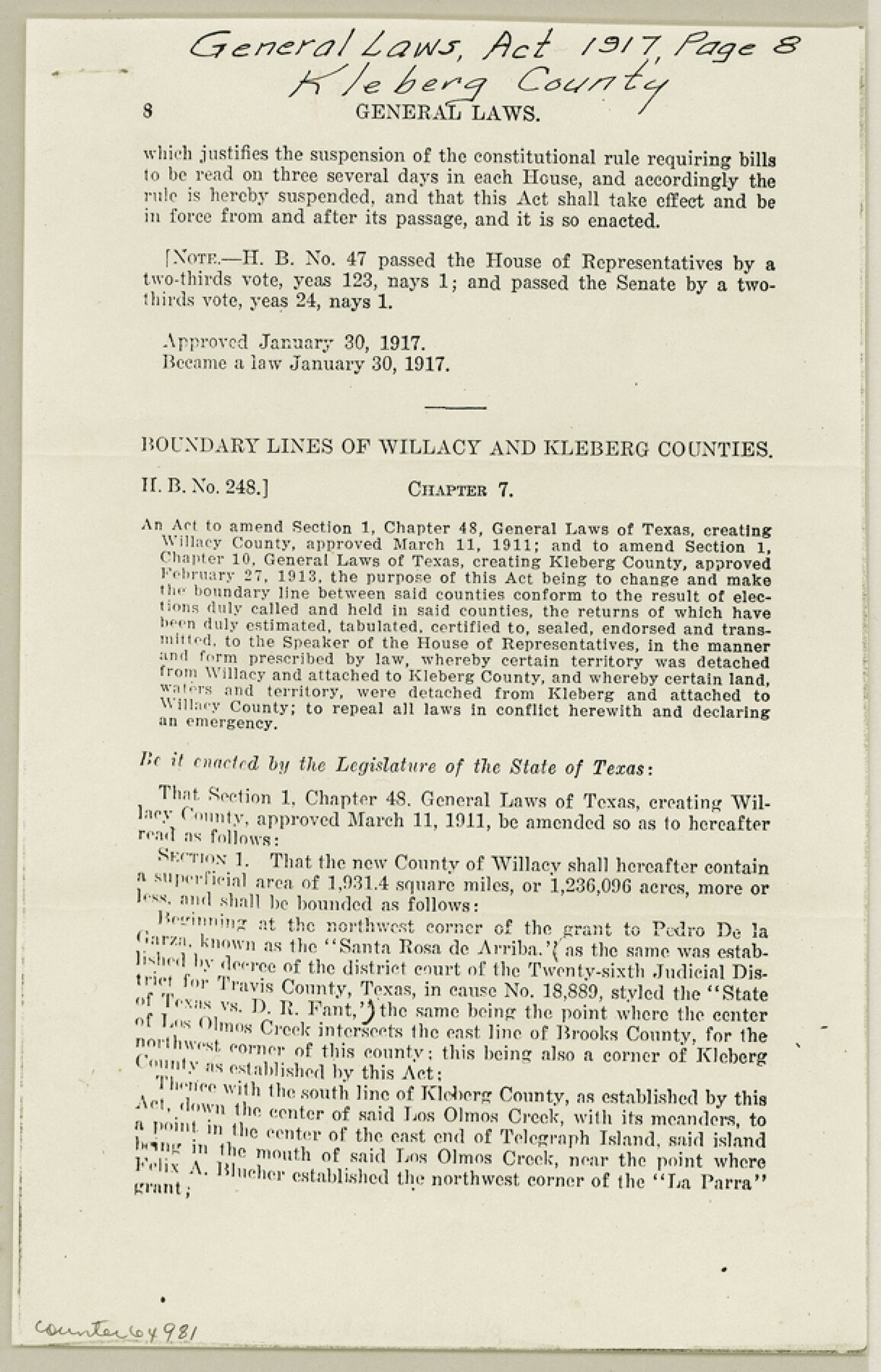
Kleberg County Boundary File 3
Boundary Lines of Willacy and Kleberg Counties
-
Map/Doc
64981
-
Collection
General Map Collection
-
Counties
Kleberg
-
Subjects
County Boundaries
-
Height x Width
9.5 x 6.1 inches
24.1 x 15.5 cm
Part of: General Map Collection
Jones County Sketch File 17

Print $20.00
- Digital $50.00
Jones County Sketch File 17
1910
Size 17.2 x 29.4 inches
Map/Doc 11902
Galveston Bay Entrance - Galveston and Texas City Harbors

Print $40.00
- Digital $50.00
Galveston Bay Entrance - Galveston and Texas City Harbors
1971
Size 33.4 x 50.1 inches
Map/Doc 69861
[Right of Way & Track Map, The Texas & Pacific Ry. Co. Main Line]
![64686, [Right of Way & Track Map, The Texas & Pacific Ry. Co. Main Line], General Map Collection](https://historictexasmaps.com/wmedia_w700/maps/64686.tif.jpg)
Print $20.00
- Digital $50.00
[Right of Way & Track Map, The Texas & Pacific Ry. Co. Main Line]
Size 11.0 x 19.0 inches
Map/Doc 64686
Cottle County Sketch File 2

Print $20.00
- Digital $50.00
Cottle County Sketch File 2
1882
Size 32.9 x 19.6 inches
Map/Doc 76757
Flight Mission No. DAG-21K, Frame 38, Matagorda County

Print $20.00
- Digital $50.00
Flight Mission No. DAG-21K, Frame 38, Matagorda County
1952
Size 18.6 x 22.3 inches
Map/Doc 86405
Hansford County Boundary File 4

Print $26.00
- Digital $50.00
Hansford County Boundary File 4
Size 14.1 x 8.7 inches
Map/Doc 54279

Cochran County Boundary File 6

Print $10.00
- Digital $50.00
Cochran County Boundary File 6
Size 10.4 x 4.3 inches
Map/Doc 51562
Tarrant County Sketch File 17

Print $8.00
- Digital $50.00
Tarrant County Sketch File 17
1860
Size 8.3 x 8.1 inches
Map/Doc 37716
Pecos County Rolled Sketch 91

Print $20.00
- Digital $50.00
Pecos County Rolled Sketch 91
Size 23.6 x 34.7 inches
Map/Doc 9710
Eastland County Working Sketch 56

Print $20.00
- Digital $50.00
Eastland County Working Sketch 56
1984
Size 39.2 x 43.3 inches
Map/Doc 68837
Val Verde County Rolled Sketch 52

Print $20.00
- Digital $50.00
Val Verde County Rolled Sketch 52
1937
Size 31.8 x 23.0 inches
Map/Doc 8121
You may also like
Armstrong County Sketch File 4a

Print $4.00
- Digital $50.00
Armstrong County Sketch File 4a
1883
Size 14.3 x 8.9 inches
Map/Doc 13687
[McLennan County School Leagues 3 and 4, Elizabeth Finley, Wm. Van Norman, Harvey Kendrick surveys and surveys to the west]
![90929, [McLennan County School Leagues 3 and 4, Elizabeth Finley, Wm. Van Norman, Harvey Kendrick surveys and surveys to the west], Twichell Survey Records](https://historictexasmaps.com/wmedia_w700/maps/90929-1.tif.jpg)
Print $20.00
- Digital $50.00
[McLennan County School Leagues 3 and 4, Elizabeth Finley, Wm. Van Norman, Harvey Kendrick surveys and surveys to the west]
Size 19.5 x 26.7 inches
Map/Doc 90929
Palo Pinto County Rolled Sketch 12

Print $20.00
- Digital $50.00
Palo Pinto County Rolled Sketch 12
1984
Size 32.2 x 28.9 inches
Map/Doc 7192
[Blocks 5-T, M-23, and vicinity]
![91230, [Blocks 5-T, M-23, and vicinity], Twichell Survey Records](https://historictexasmaps.com/wmedia_w700/maps/91230-1.tif.jpg)
Print $20.00
- Digital $50.00
[Blocks 5-T, M-23, and vicinity]
1890
Size 39.0 x 22.7 inches
Map/Doc 91230
Flight Mission No. CRC-4R, Frame 107, Chambers County

Print $20.00
- Digital $50.00
Flight Mission No. CRC-4R, Frame 107, Chambers County
1956
Size 18.8 x 22.4 inches
Map/Doc 84904
Madison County

Print $20.00
- Digital $50.00
Madison County
1871
Size 15.2 x 20.3 inches
Map/Doc 4587
Austin Map and Street Guide [Recto]
![94162, Austin Map and Street Guide [Recto], General Map Collection](https://historictexasmaps.com/wmedia_w700/maps/94162.tif.jpg)
Austin Map and Street Guide [Recto]
1976
Size 35.4 x 22.7 inches
Map/Doc 94162
Maps & Lists Showing Prison Lands (Oil & Gas) Leased as of June 1955

Digital $50.00
Maps & Lists Showing Prison Lands (Oil & Gas) Leased as of June 1955
1934
Size 29.6 x 38.1 inches
Map/Doc 62880
Travis County Appraisal District Plat Map 3_1100

Print $20.00
- Digital $50.00
Travis County Appraisal District Plat Map 3_1100
Size 21.5 x 26.4 inches
Map/Doc 94212
Flight Mission No. DQO-7K, Frame 105, Galveston County

Print $20.00
- Digital $50.00
Flight Mission No. DQO-7K, Frame 105, Galveston County
1952
Size 18.4 x 21.8 inches
Map/Doc 85120
[Lynn and Adjacent Counties]
![92961, [Lynn and Adjacent Counties], Twichell Survey Records](https://historictexasmaps.com/wmedia_w700/maps/92961-1.tif.jpg)
Print $20.00
- Digital $50.00
[Lynn and Adjacent Counties]
Size 24.6 x 18.8 inches
Map/Doc 92961
Hardin County Sketch File 21

Print $4.00
- Digital $50.00
Hardin County Sketch File 21
Size 11.2 x 8.8 inches
Map/Doc 25140