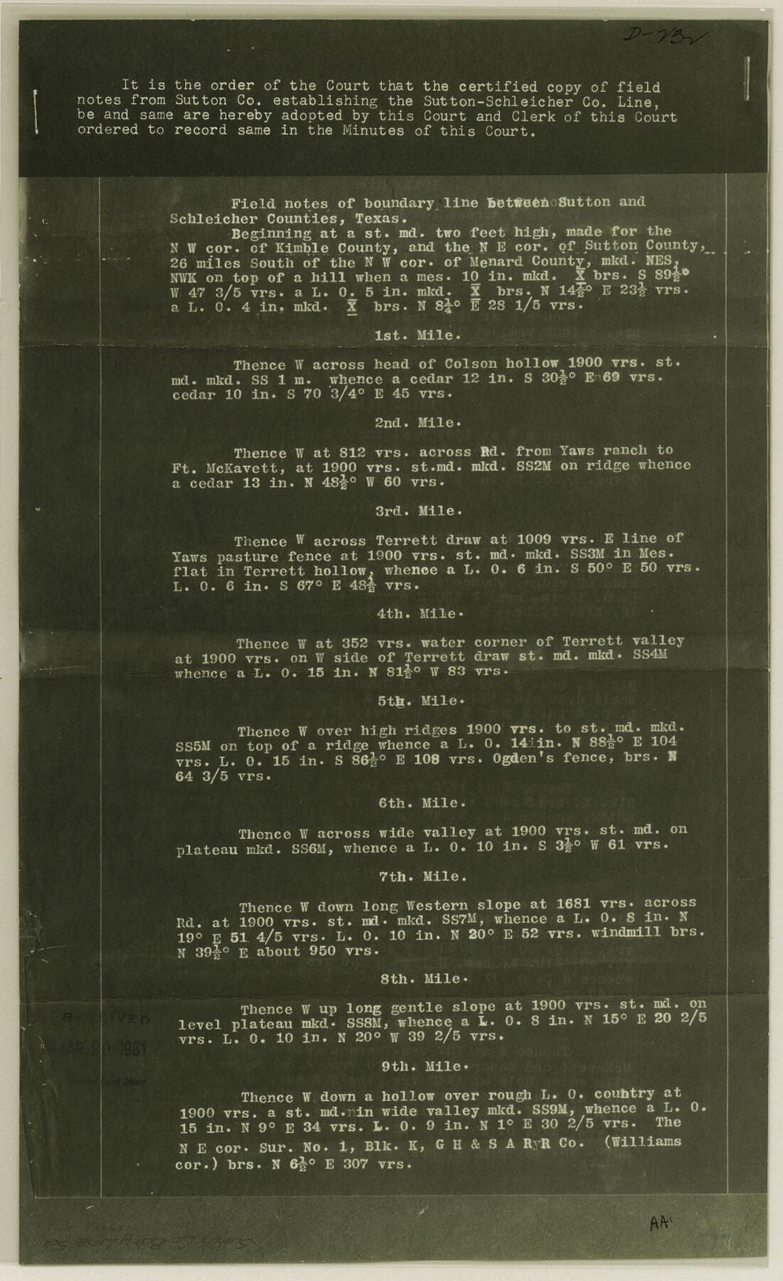
Sutton County Boundary File 5a
Copy of "Field Notes" of Sutton-Schleicher Bdy.
- 
                          Map/Doc
59060
 - 
                            Collection
General Map Collection
 - 
                            Counties
Sutton
 - 
                            Subjects
County Boundaries
 - 
                            Height x Width
14.5 x 8.9 inches
36.8 x 22.6 cm
 
Part of: General Map Collection
            Stephens County


                                            Print $20.00                    
                                             -                         Digital $50.00                                    
                Stephens County
1940
Size 42.5 x 40.4 inches
                                Map/Doc 73293
            
            Crockett County Working Sketch 7


                                            Print $20.00                    
                                             -                         Digital $50.00                                    
                Crockett County Working Sketch 7
1891
Size 18.4 x 21.7 inches
                                Map/Doc 68340
            
            Brewster County Rolled Sketch 18B


                                            Print $20.00                    
                                             -                         Digital $50.00                                    
                Brewster County Rolled Sketch 18B
1906
Size 16.2 x 18.1 inches
                                Map/Doc 5197
            
            Flight Mission No. DCL-6C, Frame 139, Kenedy County


                                            Print $20.00                    
                                             -                         Digital $50.00                                    
                Flight Mission No. DCL-6C, Frame 139, Kenedy County
1943
Size 18.7 x 22.3 inches
                                Map/Doc 85965
            
            Flight Mission No. CRC-2R, Frame 53, Chambers County


                                            Print $20.00                    
                                             -                         Digital $50.00                                    
                Flight Mission No. CRC-2R, Frame 53, Chambers County
1956
Size 18.5 x 22.4 inches
                                Map/Doc 84726
            
            Childress County


                                            Print $20.00                    
                                             -                         Digital $50.00                                    
                Childress County
1892
Size 24.7 x 19.6 inches
                                Map/Doc 3391
            
            Map of Austin's Little Colony


                                            Print $20.00                    
                                             -                         Digital $50.00                                    
                Map of Austin's Little Colony
Size 19.0 x 23.6 inches
                                Map/Doc 76008
            
            Morris County Working Sketch 3


                                            Print $20.00                    
                                             -                         Digital $50.00                                    
                Morris County Working Sketch 3
1958
Size 27.6 x 38.2 inches
                                Map/Doc 71202
            
            Brewster County Rolled Sketch 114


                                            Print $20.00                    
                                             -                         Digital $50.00                                    
                Brewster County Rolled Sketch 114
1964
Size 11.7 x 18.3 inches
                                Map/Doc 5276
            
            Texas Gulf Coast, from the Sabine River to the Rio Grande as Subdivided for Mineral Development; Aransas, Nueces, Kleberg, Kenedy, Willacy, and Cameron Counties


                                            Print $40.00                    
                                             -                         Digital $50.00                                    
                Texas Gulf Coast, from the Sabine River to the Rio Grande as Subdivided for Mineral Development; Aransas, Nueces, Kleberg, Kenedy, Willacy, and Cameron Counties
1976
Size 118.0 x 43.0 inches
                                Map/Doc 1940
            
            [10th St and 29th St Groins - Galveston]


                                            Print $6.00                    
                                             -                         Digital $50.00                                    
                [10th St and 29th St Groins - Galveston]
1983
Size 25.6 x 35.2 inches
                                Map/Doc 73621
            
            Presidio County Working Sketch 139


                                            Print $20.00                    
                                             -                         Digital $50.00                                    
                Presidio County Working Sketch 139
1990
Size 34.7 x 38.2 inches
                                Map/Doc 71817
            You may also like
            Cameron Empresario Colony. September 28, 1828


                                            Print $20.00                    
                                    
                Cameron Empresario Colony. September 28, 1828
2020
Size 10.4 x 21.7 inches
                                Map/Doc 95987
            
            Hall County Rolled Sketch 8


                                            Print $20.00                    
                                             -                         Digital $50.00                                    
                Hall County Rolled Sketch 8
1942
Size 24.7 x 41.6 inches
                                Map/Doc 6052
            
            Map of the South West Railway System - Missouri Pacific Ry., Central Branch U.P. R.R., Missouri, Kansas & Texas Ry., Texas and Pacific Ry., St. Louis, Iron Mountn. and Southern Ry., International and Great Northern Ry., and their connections


                                            Print $20.00                    
                                             -                         Digital $50.00                                    
                Map of the South West Railway System - Missouri Pacific Ry., Central Branch U.P. R.R., Missouri, Kansas & Texas Ry., Texas and Pacific Ry., St. Louis, Iron Mountn. and Southern Ry., International and Great Northern Ry., and their connections
1883
Size 15.8 x 21.2 inches
                                Map/Doc 95788
            
            [Map 1:] A Geographically Correct County Map of States Traversed by the St. Louis, Iron Mountain and Southern Railway and its connections / [Map 2:] Map of the St. Louis, Iron Mountain and Southern Railway, and connections


                                            Print $20.00                    
                                             -                         Digital $50.00                                    
                [Map 1:] A Geographically Correct County Map of States Traversed by the St. Louis, Iron Mountain and Southern Railway and its connections / [Map 2:] Map of the St. Louis, Iron Mountain and Southern Railway, and connections
1878
Size 18.9 x 32.2 inches
                                Map/Doc 95784
            
            Flight Mission No. DIX-7P, Frame 85, Aransas County


                                            Print $20.00                    
                                             -                         Digital $50.00                                    
                Flight Mission No. DIX-7P, Frame 85, Aransas County
1956
Size 18.7 x 22.4 inches
                                Map/Doc 83879
            
            Wichita County Working Sketch 25


                                            Print $20.00                    
                                             -                         Digital $50.00                                    
                Wichita County Working Sketch 25
1980
Size 27.1 x 27.7 inches
                                Map/Doc 72535
            
            Montague County Boundary File 2b


                                            Print $10.00                    
                                             -                         Digital $50.00                                    
                Montague County Boundary File 2b
Size 9.0 x 11.1 inches
                                Map/Doc 57414
            
            Edwards County Working Sketch 110


                                            Print $40.00                    
                                             -                         Digital $50.00                                    
                Edwards County Working Sketch 110
1972
Size 49.7 x 39.6 inches
                                Map/Doc 68986
            
            Navigation Maps of Gulf Intracoastal Waterway, Port Arthur to Brownsville, Texas


                                            Print $4.00                    
                                             -                         Digital $50.00                                    
                Navigation Maps of Gulf Intracoastal Waterway, Port Arthur to Brownsville, Texas
1951
Size 16.6 x 21.4 inches
                                Map/Doc 65448
            
            Harris County Sketch File 71a


                                            Print $24.00                    
                                             -                         Digital $50.00                                    
                Harris County Sketch File 71a
1941
Size 11.4 x 8.9 inches
                                Map/Doc 25525
            
            [Madison County School Land, W. Perry and other surveys to the East]


                                            Print $20.00                    
                                             -                         Digital $50.00                                    
                [Madison County School Land, W. Perry and other surveys to the East]
Size 12.9 x 18.0 inches
                                Map/Doc 90428
            
            Henderson County Rolled Sketch 11


                                            Print $20.00                    
                                             -                         Digital $50.00                                    
                Henderson County Rolled Sketch 11
1915
Size 29.0 x 42.6 inches
                                Map/Doc 76151