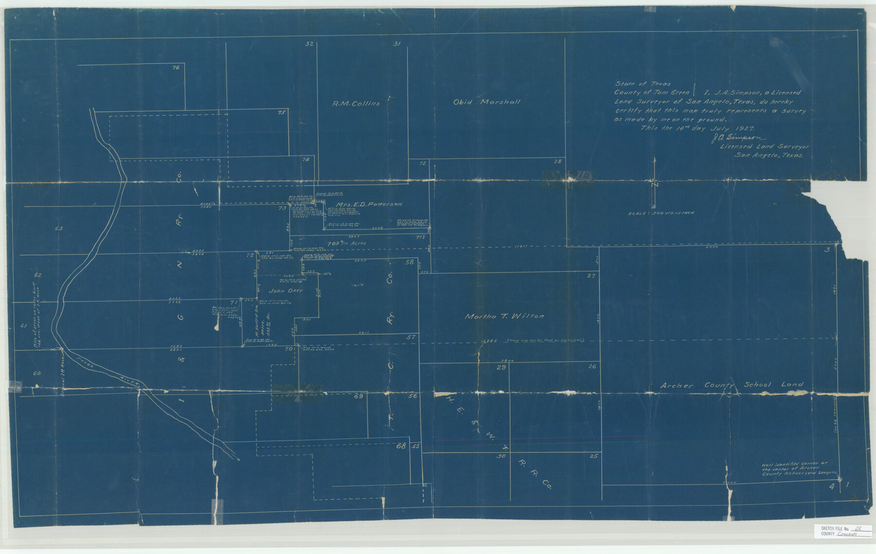
Crockett County Sketch File 65
[Sketch of surveys between the Pecos River and Archer County School Land leagues in the northwest part of the county]
-
Map/Doc
11230
-
Collection
General Map Collection
-
Object Dates
7/14/1927 (Creation Date)
7/22/1927 (File Date)
-
People and Organizations
J.A. Simpson (Surveyor/Engineer)
-
Counties
Crockett
-
Subjects
Surveying Sketch File
-
Height x Width
23.2 x 36.6 inches
58.9 x 93.0 cm
-
Medium
blueprint/diazo
-
Features
Pecos River
Part of: General Map Collection
Jefferson County Working Sketch 7

Print $20.00
- Digital $50.00
Jefferson County Working Sketch 7
1931
Size 18.0 x 18.6 inches
Map/Doc 66550
Matagorda County NRC Article 33.136 Sketch 4

Print $28.00
- Digital $50.00
Matagorda County NRC Article 33.136 Sketch 4
2008
Size 31.0 x 36.5 inches
Map/Doc 89036
Flight Mission No. CLL-3N, Frame 44, Willacy County

Print $20.00
- Digital $50.00
Flight Mission No. CLL-3N, Frame 44, Willacy County
1954
Size 18.4 x 22.0 inches
Map/Doc 87102
Van Zandt County Sketch File 29b

Print $4.00
- Digital $50.00
Van Zandt County Sketch File 29b
1859
Size 7.0 x 8.4 inches
Map/Doc 39457
Map of the International and Great Northern Railroad between Austin and San Antonio, Texas

Print $40.00
- Digital $50.00
Map of the International and Great Northern Railroad between Austin and San Antonio, Texas
1881
Size 42.5 x 121.5 inches
Map/Doc 64776
Map of Tom Green County

Print $20.00
- Digital $50.00
Map of Tom Green County
1892
Size 44.1 x 47.5 inches
Map/Doc 78389
Carta Hidrografica

Print $20.00
- Digital $50.00
Carta Hidrografica
1897
Size 26.0 x 34.3 inches
Map/Doc 96803
Lavaca County Working Sketch 20

Print $20.00
- Digital $50.00
Lavaca County Working Sketch 20
1980
Size 19.2 x 26.0 inches
Map/Doc 70373
[Surveys in Austin County]
![35, [Surveys in Austin County], General Map Collection](https://historictexasmaps.com/wmedia_w700/maps/35.tif.jpg)
Print $20.00
- Digital $50.00
[Surveys in Austin County]
1840
Size 20.8 x 28.2 inches
Map/Doc 35
Tom Green County Boundary File 87b

Print $4.00
- Digital $50.00
Tom Green County Boundary File 87b
Size 13.0 x 8.6 inches
Map/Doc 59401
Hardin County Rolled Sketch MH

Print $21.00
- Digital $50.00
Hardin County Rolled Sketch MH
1936
Size 10.1 x 15.2 inches
Map/Doc 45760
Lampasas County Rolled Sketch 2

Print $20.00
- Digital $50.00
Lampasas County Rolled Sketch 2
Size 21.0 x 39.2 inches
Map/Doc 6565
You may also like
Brazoria County Sketch File 59

Print $364.00
- Digital $50.00
Brazoria County Sketch File 59
1996
Size 14.9 x 8.3 inches
Map/Doc 15398
Flight Mission No. DQO-3K, Frame 82, Galveston County

Print $20.00
- Digital $50.00
Flight Mission No. DQO-3K, Frame 82, Galveston County
1952
Size 18.7 x 22.5 inches
Map/Doc 85087
Harris County Working Sketch 16

Print $20.00
- Digital $50.00
Harris County Working Sketch 16
1916
Size 19.8 x 21.2 inches
Map/Doc 65908
Working Sketch in Terrell County

Print $3.00
- Digital $50.00
Working Sketch in Terrell County
1927
Size 17.1 x 9.5 inches
Map/Doc 92911
Presidio County Sketch File 87

Print $6.00
- Digital $50.00
Presidio County Sketch File 87
1951
Size 14.5 x 8.7 inches
Map/Doc 34748
[Surveys in Austin's Colony south of the San Antonio Road and west of the Colorado River]
![50, [Surveys in Austin's Colony south of the San Antonio Road and west of the Colorado River], General Map Collection](https://historictexasmaps.com/wmedia_w700/maps/50.tif.jpg)
Print $20.00
- Digital $50.00
[Surveys in Austin's Colony south of the San Antonio Road and west of the Colorado River]
1840
Size 16.8 x 22.2 inches
Map/Doc 50
Leon County Rolled Sketch 7

Print $40.00
- Digital $50.00
Leon County Rolled Sketch 7
1954
Size 55.9 x 35.0 inches
Map/Doc 9428
Ochiltree County Boundary File 10

Print $24.00
- Digital $50.00
Ochiltree County Boundary File 10
Size 11.2 x 8.7 inches
Map/Doc 57728
Galveston County Working Sketch 10

Print $20.00
- Digital $50.00
Galveston County Working Sketch 10
Size 27.0 x 8.9 inches
Map/Doc 62190
Flight Mission No. BQR-9K, Frame 50, Brazoria County

Print $20.00
- Digital $50.00
Flight Mission No. BQR-9K, Frame 50, Brazoria County
1952
Size 18.7 x 22.4 inches
Map/Doc 84054
King County Sketch File 12

Print $10.00
- Digital $50.00
King County Sketch File 12
1903
Size 11.3 x 8.6 inches
Map/Doc 29105
Hardeman County Boundary File 3

Print $18.00
- Digital $50.00
Hardeman County Boundary File 3
Size 14.1 x 8.8 inches
Map/Doc 54375