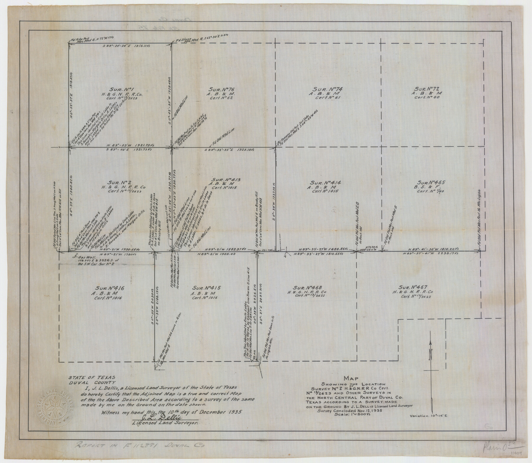
Duval County Sketch File 75
Map Showing the Location of Survey No. 2 H&GNRR Co. Cert. No. 13/2623 and Other Surveys of Duval Co. Texas According to a Survey Made on the Ground
-
Map/Doc
11409
-
Collection
General Map Collection
-
Object Dates
1935/11/12 (Creation Date)
1935/11/12 (Survey Date)
-
People and Organizations
J.L. Dellis (Surveyor/Engineer)
-
Counties
Duval
-
Subjects
Surveying Sketch File
-
Height x Width
18.0 x 28.5 inches
45.7 x 72.4 cm
-
Medium
paper, manuscript
-
Scale
1:500
Part of: General Map Collection
Dallam County Sketch File 6

Print $60.00
- Digital $50.00
Dallam County Sketch File 6
Size 12.4 x 17.0 inches
Map/Doc 20350
Stephens County Sketch File 26

Print $10.00
- Digital $50.00
Stephens County Sketch File 26
Size 14.1 x 8.8 inches
Map/Doc 37096
Wichita County Rolled Sketch 5

Print $20.00
- Digital $50.00
Wichita County Rolled Sketch 5
Size 24.1 x 39.2 inches
Map/Doc 8242
Runnels County Working Sketch 28

Print $20.00
- Digital $50.00
Runnels County Working Sketch 28
1959
Size 41.9 x 35.2 inches
Map/Doc 63624
Reagan County

Print $40.00
- Digital $50.00
Reagan County
1940
Size 50.8 x 41.2 inches
Map/Doc 95621
Travis County Sketch File 38

Print $20.00
- Digital $50.00
Travis County Sketch File 38
1913
Size 16.6 x 17.4 inches
Map/Doc 12462
Midland County Rolled Sketch 1

Print $20.00
- Digital $50.00
Midland County Rolled Sketch 1
1940
Size 32.9 x 35.0 inches
Map/Doc 9512
Webb County Working Sketch 68

Print $40.00
- Digital $50.00
Webb County Working Sketch 68
1967
Size 31.6 x 50.7 inches
Map/Doc 72435
Schleicher County Sketch File 44

Print $4.00
- Digital $50.00
Schleicher County Sketch File 44
1950
Size 8.9 x 14.4 inches
Map/Doc 36550
Flight Mission No. CUG-1P, Frame 170, Kleberg County

Print $20.00
- Digital $50.00
Flight Mission No. CUG-1P, Frame 170, Kleberg County
1956
Size 18.5 x 22.2 inches
Map/Doc 86177
S. M. S. Throckmorton Ranch, Throckmorton, Haskell, Baylor Cos.

Print $20.00
- Digital $50.00
S. M. S. Throckmorton Ranch, Throckmorton, Haskell, Baylor Cos.
1955
Size 33.8 x 45.1 inches
Map/Doc 2104
Brewster County Sketch File N-3d

Print $13.00
- Digital $50.00
Brewster County Sketch File N-3d
1889
Size 14.2 x 8.7 inches
Map/Doc 15596
You may also like
Ward County Working Sketch 40

Print $20.00
- Digital $50.00
Ward County Working Sketch 40
1969
Size 24.4 x 45.7 inches
Map/Doc 72346
[Texas Boundary Line]
![92077, [Texas Boundary Line], Twichell Survey Records](https://historictexasmaps.com/wmedia_w700/maps/92077-1.tif.jpg)
Print $20.00
- Digital $50.00
[Texas Boundary Line]
Size 21.2 x 12.0 inches
Map/Doc 92077
Smith County Rolled Sketch 6A3

Print $40.00
- Digital $50.00
Smith County Rolled Sketch 6A3
1990
Size 48.6 x 36.8 inches
Map/Doc 10698
Harris County Rolled Sketch W

Print $40.00
- Digital $50.00
Harris County Rolled Sketch W
1936
Size 43.0 x 64.4 inches
Map/Doc 9124
Section 50, H. & G. N. Block 1

Print $20.00
- Digital $50.00
Section 50, H. & G. N. Block 1
Size 18.8 x 24.9 inches
Map/Doc 90816
North Sulphur River, Kinsing Sheet

Print $20.00
- Digital $50.00
North Sulphur River, Kinsing Sheet
1925
Size 18.6 x 23.4 inches
Map/Doc 78331
Outer Continental Shelf Leasing Maps (Louisiana Offshore Operations)

Print $20.00
- Digital $50.00
Outer Continental Shelf Leasing Maps (Louisiana Offshore Operations)
1959
Size 21.4 x 13.9 inches
Map/Doc 76099
Zapata County Sketch File 12

Print $20.00
- Digital $50.00
Zapata County Sketch File 12
1918
Size 15.6 x 33.0 inches
Map/Doc 12721
Refugio County Boundary File 2a

Print $8.00
- Digital $50.00
Refugio County Boundary File 2a
Size 14.5 x 9.1 inches
Map/Doc 58240


Andrews County Sketch File 17

Print $8.00
- Digital $50.00
Andrews County Sketch File 17
Size 11.1 x 8.6 inches
Map/Doc 12901