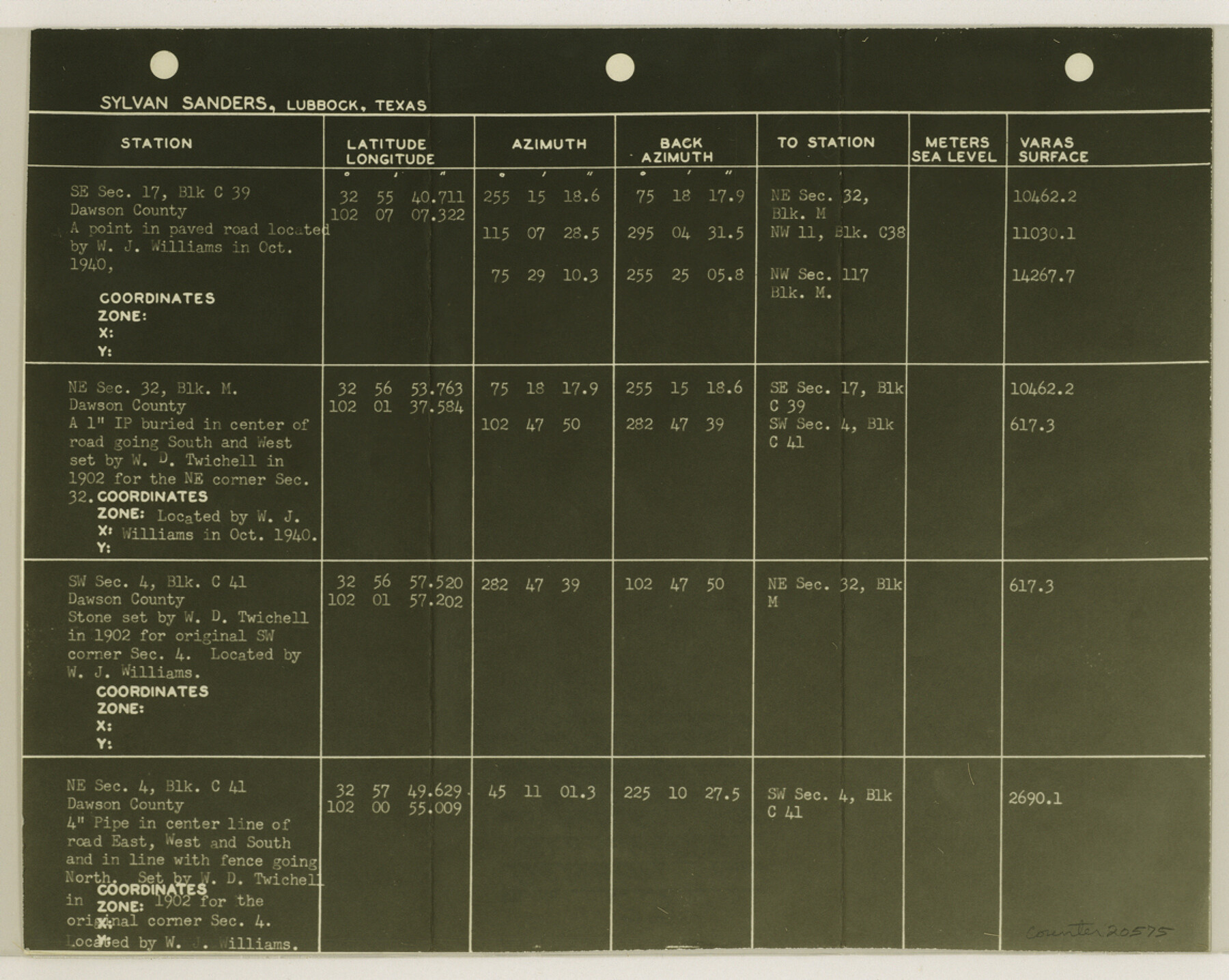
Dawson County Sketch File 23
[List of control stations]
-
Map/Doc
20575
-
Collection
General Map Collection
-
Object Dates
1958/2/5 (File Date)
-
People and Organizations
Sylvan Sanders (Surveyor/Engineer)
-
Counties
Dawson
-
Subjects
Surveying Sketch File
-
Height x Width
9.2 x 11.5 inches
23.4 x 29.2 cm
-
Medium
photostat, negative
Part of: General Map Collection
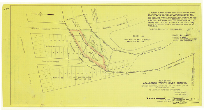
Dallas County Rolled Sketch 4A
Print $20.00
- Digital $50.00
Dallas County Rolled Sketch 4A
1954
Size 12.5 x 23.1 inches
Map/Doc 5688
Cameron County Working Sketch 2

Print $40.00
- Digital $50.00
Cameron County Working Sketch 2
1937
Size 43.1 x 51.7 inches
Map/Doc 67881
Flight Mission No. DCL-6C, Frame 65, Kenedy County

Print $20.00
- Digital $50.00
Flight Mission No. DCL-6C, Frame 65, Kenedy County
1943
Size 18.5 x 22.3 inches
Map/Doc 85907
Texas & Pacific Railway, Longview to Dallas

Print $40.00
- Digital $50.00
Texas & Pacific Railway, Longview to Dallas
1873
Size 14.8 x 100.8 inches
Map/Doc 64099
Pecos County Working Sketch 78

Print $20.00
- Digital $50.00
Pecos County Working Sketch 78
1960
Size 29.4 x 34.4 inches
Map/Doc 71550
Flight Mission No. BQR-20K, Frame 13, Brazoria County

Print $20.00
- Digital $50.00
Flight Mission No. BQR-20K, Frame 13, Brazoria County
1952
Size 18.6 x 22.3 inches
Map/Doc 84115
Brazos River, Brazos River Sheet 4

Print $20.00
- Digital $50.00
Brazos River, Brazos River Sheet 4
1926
Size 19.4 x 32.1 inches
Map/Doc 69668
Motley County Sketch File 3A (N)

Print $20.00
- Digital $50.00
Motley County Sketch File 3A (N)
Size 12.3 x 17.5 inches
Map/Doc 42136
Wichita County Working Sketch 26

Print $20.00
- Digital $50.00
Wichita County Working Sketch 26
1981
Size 13.1 x 21.0 inches
Map/Doc 72536
Polk County Sketch File 28

Print $4.00
- Digital $50.00
Polk County Sketch File 28
Size 8.6 x 9.9 inches
Map/Doc 34198
Concho County Boundary File 3

Print $10.00
- Digital $50.00
Concho County Boundary File 3
Size 8.5 x 3.9 inches
Map/Doc 51820

You may also like
Reagan County Rolled Sketch 13

Print $20.00
- Digital $50.00
Reagan County Rolled Sketch 13
Size 25.5 x 38.0 inches
Map/Doc 7441
Map of north end of Brazos Island

Print $20.00
- Digital $50.00
Map of north end of Brazos Island
Size 27.7 x 18.3 inches
Map/Doc 72907
Karnes County Sketch File 11

Print $4.00
- Digital $50.00
Karnes County Sketch File 11
1885
Size 10.5 x 8.1 inches
Map/Doc 28602
Flight Mission No. DCL-7C, Frame 108, Kenedy County

Print $20.00
- Digital $50.00
Flight Mission No. DCL-7C, Frame 108, Kenedy County
1943
Size 18.3 x 22.2 inches
Map/Doc 86073
Grayson County Sketch File 11

Print $4.00
- Digital $50.00
Grayson County Sketch File 11
1857
Size 13.0 x 8.0 inches
Map/Doc 24476
Nueces County Rolled Sketch 75

Print $40.00
- Digital $50.00
Nueces County Rolled Sketch 75
1945
Size 56.0 x 24.0 inches
Map/Doc 9618
Map of Callahan Co[unty]
![88916, Map of Callahan Co[unty], Library of Congress](https://historictexasmaps.com/wmedia_w700/maps/88916.tif.jpg)
Print $20.00
Map of Callahan Co[unty]
1879
Size 24.7 x 18.5 inches
Map/Doc 88916
Harris County Historic Topographic 36

Print $20.00
- Digital $50.00
Harris County Historic Topographic 36
1916
Size 29.5 x 23.0 inches
Map/Doc 65847
The Republic County of San Patricio. Proposed, Late Fall 1837-December 31, 1838

Print $20.00
The Republic County of San Patricio. Proposed, Late Fall 1837-December 31, 1838
2020
Size 22.2 x 21.7 inches
Map/Doc 96274
Township 1 North Range 11 West, North Western District, Louisiana

Print $3.00
- Digital $50.00
Township 1 North Range 11 West, North Western District, Louisiana
1884
Size 17.5 x 21.5 inches
Map/Doc 65892
Midland County Working Sketch 14

Print $40.00
- Digital $50.00
Midland County Working Sketch 14
1953
Size 65.0 x 31.0 inches
Map/Doc 70994
Gregg County Sketch File 3

Print $6.00
- Digital $50.00
Gregg County Sketch File 3
1931
Size 11.2 x 8.7 inches
Map/Doc 24569