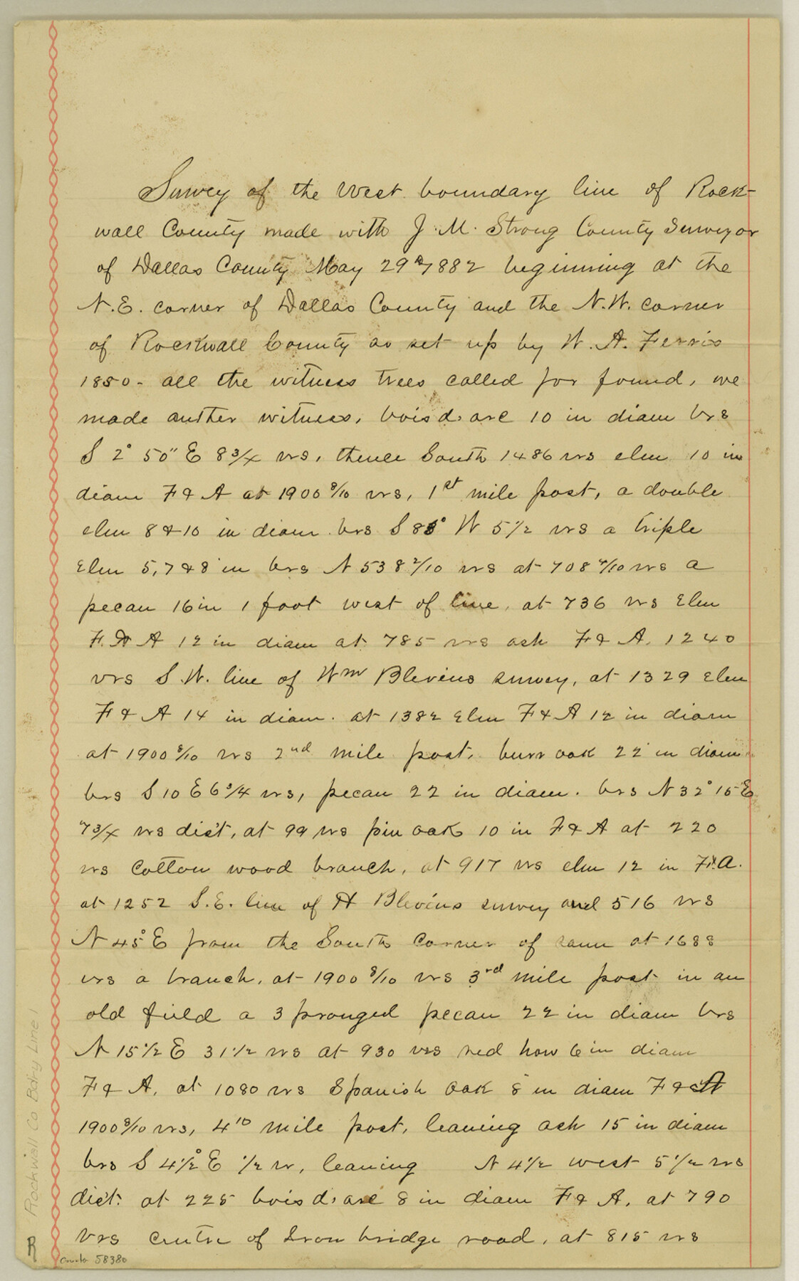
Rockwall County Boundary File 1
Field Notes of Co. Line between Dallas & Rockwall
-
Map/Doc
58380
-
Collection
General Map Collection
-
Counties
Rockwall
-
Subjects
County Boundaries
-
Height x Width
13.3 x 8.3 inches
33.8 x 21.1 cm
Part of: General Map Collection
Crane County Rolled Sketch 22

Print $20.00
- Digital $50.00
Crane County Rolled Sketch 22
1990
Size 12.5 x 19.3 inches
Map/Doc 5578
Mills County Rolled Sketch 5

Print $20.00
- Digital $50.00
Mills County Rolled Sketch 5
2001
Size 27.1 x 21.6 inches
Map/Doc 6783
Edwards County Sketch File 28

Print $5.00
- Digital $50.00
Edwards County Sketch File 28
Size 27.3 x 25.6 inches
Map/Doc 11431
Flight Mission No. DQN-3K, Frame 69, Calhoun County

Print $20.00
- Digital $50.00
Flight Mission No. DQN-3K, Frame 69, Calhoun County
1953
Size 18.5 x 22.3 inches
Map/Doc 84360
Moore County Working Sketch 15

Print $20.00
- Digital $50.00
Moore County Working Sketch 15
1981
Size 20.8 x 35.3 inches
Map/Doc 71197
Flight Mission No. BRA-8M, Frame 146, Jefferson County

Print $20.00
- Digital $50.00
Flight Mission No. BRA-8M, Frame 146, Jefferson County
1953
Size 16.0 x 16.1 inches
Map/Doc 85638
[Map of Tom Green County]
![4085, [Map of Tom Green County], General Map Collection](https://historictexasmaps.com/wmedia_w700/maps/4085-2.tif.jpg)
Print $20.00
- Digital $50.00
[Map of Tom Green County]
Size 23.9 x 36.5 inches
Map/Doc 4085
Panola County Sketch File 18

Print $20.00
- Digital $50.00
Panola County Sketch File 18
1909
Size 24.2 x 18.7 inches
Map/Doc 12138
Flight Mission No. CRC-4R, Frame 96, Chambers County

Print $20.00
- Digital $50.00
Flight Mission No. CRC-4R, Frame 96, Chambers County
1956
Size 18.4 x 22.2 inches
Map/Doc 84893
Hill County Sketch File 20

Print $22.00
- Digital $50.00
Hill County Sketch File 20
1854
Size 8.3 x 7.7 inches
Map/Doc 26490
Victoria County Sketch File 2

Print $7.00
- Digital $50.00
Victoria County Sketch File 2
1873
Size 10.3 x 8.4 inches
Map/Doc 39511
Pecos County Rolled Sketch 122

Print $20.00
- Digital $50.00
Pecos County Rolled Sketch 122
1945
Size 32.5 x 39.1 inches
Map/Doc 7263
You may also like
Houston County Sketch File 4a

Print $4.00
- Digital $50.00
Houston County Sketch File 4a
1858
Size 13.0 x 8.3 inches
Map/Doc 26754
D No. 3 - Sketch of Ocracoke Inlet, North Carolina

Print $20.00
- Digital $50.00
D No. 3 - Sketch of Ocracoke Inlet, North Carolina
1852
Size 17.0 x 16.1 inches
Map/Doc 97210
Midland County Boundary File 1

Print $40.00
- Digital $50.00
Midland County Boundary File 1
Size 7.0 x 6.6 inches
Map/Doc 57140
Flight Mission No. BRA-7M, Frame 188, Jefferson County

Print $20.00
- Digital $50.00
Flight Mission No. BRA-7M, Frame 188, Jefferson County
1953
Size 18.6 x 22.3 inches
Map/Doc 85556
[Galveston, Harrisburg & San Antonio Railroad from Cuero to Stockdale]
![64203, [Galveston, Harrisburg & San Antonio Railroad from Cuero to Stockdale], General Map Collection](https://historictexasmaps.com/wmedia_w700/maps/64203.tif.jpg)
Print $20.00
- Digital $50.00
[Galveston, Harrisburg & San Antonio Railroad from Cuero to Stockdale]
1907
Size 13.2 x 33.1 inches
Map/Doc 64203
Hardeman County Working Sketch 5

Print $20.00
- Digital $50.00
Hardeman County Working Sketch 5
Size 23.0 x 35.7 inches
Map/Doc 63386
[Northwest part of County]
![90616, [Northwest part of County], Twichell Survey Records](https://historictexasmaps.com/wmedia_w700/maps/90616-1.tif.jpg)
Print $20.00
- Digital $50.00
[Northwest part of County]
Size 17.4 x 22.5 inches
Map/Doc 90616
Railroad Track Map, H&TCRRCo., Falls County, Texas

Print $4.00
- Digital $50.00
Railroad Track Map, H&TCRRCo., Falls County, Texas
1918
Size 11.4 x 18.5 inches
Map/Doc 62859
Ochiltree County

Print $20.00
- Digital $50.00
Ochiltree County
Size 14.3 x 16.5 inches
Map/Doc 91491
General Highway Map, Tyler County, Texas

Print $20.00
General Highway Map, Tyler County, Texas
1940
Size 24.8 x 18.1 inches
Map/Doc 79264
Amistad International Reservoir on Rio Grande 77

Print $20.00
- Digital $50.00
Amistad International Reservoir on Rio Grande 77
1949
Size 28.5 x 40.2 inches
Map/Doc 75505
Intracoastal Waterway in Texas - Corpus Christi to Point Isabel including Arroyo Colorado to Mo. Pac. R.R. Bridge Near Harlingen

Print $20.00
- Digital $50.00
Intracoastal Waterway in Texas - Corpus Christi to Point Isabel including Arroyo Colorado to Mo. Pac. R.R. Bridge Near Harlingen
1933
Size 28.2 x 41.0 inches
Map/Doc 61854