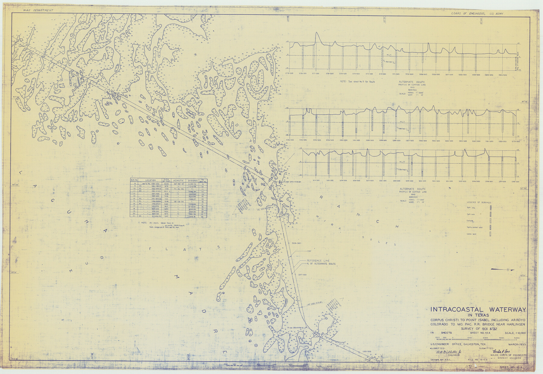
Intracoastal Waterway in Texas - Corpus Christi to Point Isabel including Arroyo Colorado to Mo. Pac. R.R. Bridge Near Harlingen
-
Map/Doc
61854
-
Collection
General Map Collection
-
Object Dates
1933 (Creation Date)
-
Subjects
Intracoastal Waterways
-
Height x Width
28.2 x 41.0 inches
71.6 x 104.1 cm
Part of: General Map Collection
Flight Mission No. BQR-12K, Frame 50, Brazoria County

Print $20.00
- Digital $50.00
Flight Mission No. BQR-12K, Frame 50, Brazoria County
1952
Size 18.7 x 22.4 inches
Map/Doc 84065
Leon County Working Sketch 60

Print $20.00
- Digital $50.00
Leon County Working Sketch 60
2005
Size 20.7 x 31.3 inches
Map/Doc 83575
Reeves County Working Sketch 4a

Print $20.00
- Digital $50.00
Reeves County Working Sketch 4a
1933
Size 26.0 x 34.6 inches
Map/Doc 63447
Grayson County Working Sketch 16

Print $20.00
- Digital $50.00
Grayson County Working Sketch 16
1954
Size 44.2 x 24.7 inches
Map/Doc 63255
Matagorda County Sketch File 26

Print $24.00
- Digital $50.00
Matagorda County Sketch File 26
1903
Size 14.4 x 8.7 inches
Map/Doc 30791
Medina County Sketch File 5

Print $8.00
- Digital $50.00
Medina County Sketch File 5
Size 8.2 x 3.8 inches
Map/Doc 31450
Bexar County Sketch File 40

Print $4.00
- Digital $50.00
Bexar County Sketch File 40
Size 8.4 x 7.0 inches
Map/Doc 14514
Flight Mission No. BRA-16M, Frame 105, Jefferson County

Print $20.00
- Digital $50.00
Flight Mission No. BRA-16M, Frame 105, Jefferson County
1953
Size 18.5 x 22.1 inches
Map/Doc 85717
Lavaca County Working Sketch 19

Print $20.00
- Digital $50.00
Lavaca County Working Sketch 19
1980
Size 26.9 x 29.6 inches
Map/Doc 70372
Flight Mission No. BQR-13K, Frame 161, Brazoria County

Print $20.00
- Digital $50.00
Flight Mission No. BQR-13K, Frame 161, Brazoria County
1952
Size 18.7 x 22.3 inches
Map/Doc 84086
Runnels County Rolled Sketch 46

Print $20.00
- Digital $50.00
Runnels County Rolled Sketch 46
1954
Size 33.5 x 39.0 inches
Map/Doc 9872
Boundary Between the United States & Mexico Agreed upon by the Joint Commission under the Treaty of Guadalupe Hidalgo

Print $20.00
- Digital $50.00
Boundary Between the United States & Mexico Agreed upon by the Joint Commission under the Treaty of Guadalupe Hidalgo
1853
Size 18.4 x 26.5 inches
Map/Doc 72884
You may also like
Oyster Creek, Texas showing connection with Brazos River & Oyster Bay by the Galveston & Brazos Canal for a Light Draft Navigation

Print $40.00
- Digital $50.00
Oyster Creek, Texas showing connection with Brazos River & Oyster Bay by the Galveston & Brazos Canal for a Light Draft Navigation
Size 18.0 x 52.9 inches
Map/Doc 96562
Anderson County Sketch File 32

Print $4.00
- Digital $50.00
Anderson County Sketch File 32
2002
Size 11.3 x 8.8 inches
Map/Doc 78312

Dimmit County Rolled Sketch 11

Print $20.00
- Digital $50.00
Dimmit County Rolled Sketch 11
1942
Size 21.8 x 28.9 inches
Map/Doc 5720
Aransas County Working Sketch 5

Print $20.00
- Digital $50.00
Aransas County Working Sketch 5
1928
Size 19.7 x 23.2 inches
Map/Doc 67172
Kaufman County Boundary File 6b

Print $6.00
- Digital $50.00
Kaufman County Boundary File 6b
Size 14.2 x 8.5 inches
Map/Doc 55966
Val Verde County Sketch File A1 1/2

Print $20.00
- Digital $50.00
Val Verde County Sketch File A1 1/2
Size 24.8 x 17.3 inches
Map/Doc 12539
Colorado River, Taiton Sheet

Print $6.00
- Digital $50.00
Colorado River, Taiton Sheet
1941
Size 24.4 x 32.8 inches
Map/Doc 65311
Fisher County

Print $20.00
- Digital $50.00
Fisher County
1880
Size 29.4 x 25.3 inches
Map/Doc 75772
Map of the United States, Canada and a part of Mexico to illustrate Olney's school geography

Print $20.00
- Digital $50.00
Map of the United States, Canada and a part of Mexico to illustrate Olney's school geography
1844
Size 12.1 x 19.0 inches
Map/Doc 93537
Dimmit County Sketch File 31

Print $20.00
- Digital $50.00
Dimmit County Sketch File 31
1894
Size 12.7 x 17.3 inches
Map/Doc 11352
Flight Mission No. BRA-8M, Frame 64, Jefferson County

Print $20.00
- Digital $50.00
Flight Mission No. BRA-8M, Frame 64, Jefferson County
1953
Size 18.5 x 22.3 inches
Map/Doc 85584