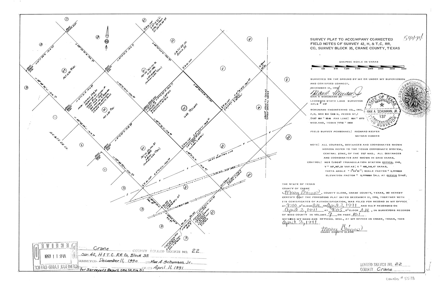
Crane County Rolled Sketch 22
Survey plat to accompany corrected field notes of survey 42, H. & T. C. RR. Co. survey Block 35, Crane County, Texas
-
Map/Doc
5578
-
Collection
General Map Collection
-
Object Dates
1990/12/11 (Creation Date)
1991/4/11 (File Date)
-
People and Organizations
Max A. Schumann, Jr. (Surveyor/Engineer)
Richard Keifer (Chainman/Field Personnel)
Nathan Hughes (Chainman/Field Personnel)
-
Counties
Crane
-
Subjects
Surveying Rolled Sketch
-
Height x Width
12.5 x 19.3 inches
31.8 x 49.0 cm
-
Medium
mylar, print
-
Comments
See Crane County Sketch File 31 (19620) for surveyor’s report.
Related maps
Crane County Sketch File 31

Print $8.00
- Digital $50.00
Crane County Sketch File 31
1991
Size 11.3 x 8.9 inches
Map/Doc 19620
Part of: General Map Collection
Baylor County Boundary File 3

Print $52.00
- Digital $50.00
Baylor County Boundary File 3
Size 23.2 x 4.9 inches
Map/Doc 50372
Flight Mission No. CRC-5R, Frame 32, Chambers County

Print $20.00
- Digital $50.00
Flight Mission No. CRC-5R, Frame 32, Chambers County
1956
Size 18.5 x 22.4 inches
Map/Doc 84951
Martin County Boundary File 2a

Print $6.00
- Digital $50.00
Martin County Boundary File 2a
Size 14.1 x 8.8 inches
Map/Doc 56776
Goliad County Sketch File 16

Print $40.00
- Digital $50.00
Goliad County Sketch File 16
Size 13.4 x 15.8 inches
Map/Doc 24247
Harris County Working Sketch 29

Print $20.00
- Digital $50.00
Harris County Working Sketch 29
1934
Size 22.6 x 30.5 inches
Map/Doc 65921
El Paso County Rolled Sketch 52

Print $20.00
- Digital $50.00
El Paso County Rolled Sketch 52
1960
Size 18.4 x 24.4 inches
Map/Doc 5841
Baylor County Sketch File 12C

Print $8.00
- Digital $50.00
Baylor County Sketch File 12C
1900
Size 13.5 x 8.8 inches
Map/Doc 14155
Marion County Working Sketch 9

Print $20.00
- Digital $50.00
Marion County Working Sketch 9
1940
Size 23.5 x 25.5 inches
Map/Doc 70784
Atascosa County Sketch File 2

Print $8.00
- Digital $50.00
Atascosa County Sketch File 2
1847
Size 7.8 x 5.9 inches
Map/Doc 13724
Runnels County Sketch File 15

Print $42.00
Runnels County Sketch File 15
1883
Size 9.2 x 7.9 inches
Map/Doc 35459
United States Bathymetric and Fishing Maps including Topographic/Bathymetric Maps

Print $40.00
- Digital $50.00
United States Bathymetric and Fishing Maps including Topographic/Bathymetric Maps
1989
Size 21.8 x 54.8 inches
Map/Doc 73556
Andrews County Rolled Sketch 20

Print $20.00
- Digital $50.00
Andrews County Rolled Sketch 20
Size 31.6 x 40.0 inches
Map/Doc 8395
You may also like
Refugio County Working Sketch 4

Print $20.00
- Digital $50.00
Refugio County Working Sketch 4
1937
Size 33.2 x 31.4 inches
Map/Doc 63513
Map of the Reconnaissance in Texas by Lieuts Blake & Meade of the Corps of Topl. Engrs.

Print $20.00
- Digital $50.00
Map of the Reconnaissance in Texas by Lieuts Blake & Meade of the Corps of Topl. Engrs.
1845
Size 27.7 x 18.2 inches
Map/Doc 72893
Flight Mission No. BRE-2P, Frame 52, Nueces County

Print $20.00
- Digital $50.00
Flight Mission No. BRE-2P, Frame 52, Nueces County
1956
Size 18.5 x 22.4 inches
Map/Doc 86754
Archer County Sketch File 23

Print $40.00
- Digital $50.00
Archer County Sketch File 23
1936
Size 25.3 x 23.4 inches
Map/Doc 10831
Tom Green County Sketch File 50

Print $20.00
- Digital $50.00
Tom Green County Sketch File 50
1884
Size 25.4 x 34.5 inches
Map/Doc 12442
Flight Mission No. DCL-6C, Frame 124, Kenedy County

Print $20.00
- Digital $50.00
Flight Mission No. DCL-6C, Frame 124, Kenedy County
1943
Size 18.6 x 22.4 inches
Map/Doc 85954
Map of Hill County

Print $20.00
- Digital $50.00
Map of Hill County
1857
Size 21.5 x 25.6 inches
Map/Doc 3672
Reeves County Working Sketch 41

Print $40.00
- Digital $50.00
Reeves County Working Sketch 41
1973
Size 42.5 x 53.4 inches
Map/Doc 63484
Houston Ship Channel, Alexander Island to Carpenter Bayou

Print $40.00
- Digital $50.00
Houston Ship Channel, Alexander Island to Carpenter Bayou
1992
Size 35.3 x 49.3 inches
Map/Doc 69917
Lavaca County Rolled Sketch 6

Print $20.00
- Digital $50.00
Lavaca County Rolled Sketch 6
1986
Size 44.8 x 33.9 inches
Map/Doc 10290
Navarro County Rolled Sketch 3

Print $20.00
- Digital $50.00
Navarro County Rolled Sketch 3
1893
Size 15.3 x 18.6 inches
Map/Doc 6838
Hamilton County Rolled Sketch 9

Print $20.00
- Digital $50.00
Hamilton County Rolled Sketch 9
1903
Size 32.8 x 30.4 inches
Map/Doc 9098