Mills County Rolled Sketch 5
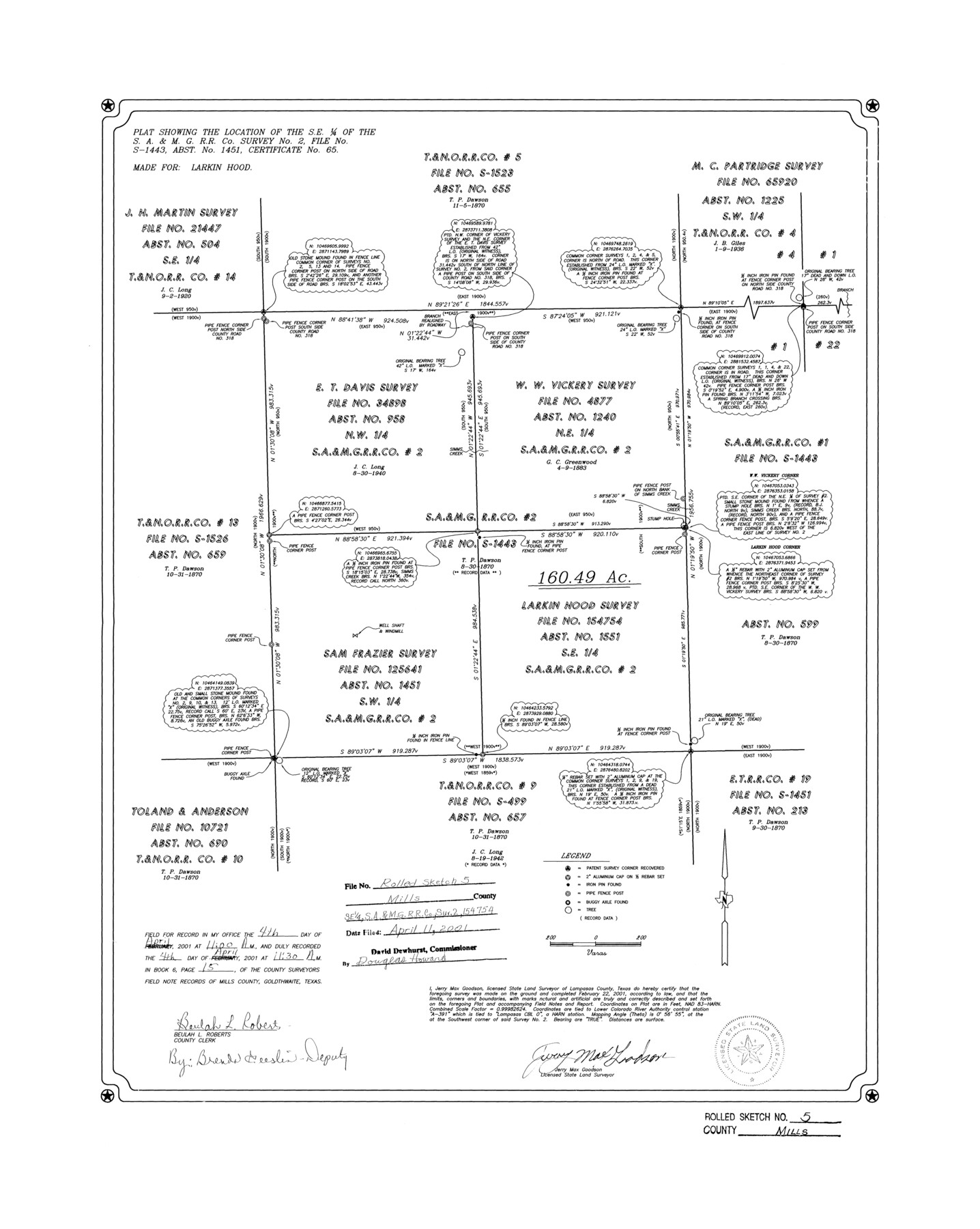
Plat showing the location of the SE 1/4 of the S. A. & M. G. R.R. Co. survey no. 2, file no. S-1443, abst. no. 1451, certificate no. 65
-
Map/Doc
6783
-
Collection
General Map Collection
-
Object Dates
2001/2/22 (Creation Date)
2001/4/11 (File Date)
-
People and Organizations
Jerry Max Goodson (Surveyor/Engineer)
-
Counties
Mills
-
Subjects
Surveying Rolled Sketch
-
Height x Width
27.1 x 21.6 inches
68.8 x 54.9 cm
-
Medium
mylar, print
Part of: General Map Collection
Flight Mission No. DIX-7P, Frame 20, Aransas County

Print $20.00
- Digital $50.00
Flight Mission No. DIX-7P, Frame 20, Aransas County
1956
Size 18.8 x 22.5 inches
Map/Doc 83872
Flight Mission No. BRA-3M, Frame 198, Jefferson County

Print $20.00
- Digital $50.00
Flight Mission No. BRA-3M, Frame 198, Jefferson County
1953
Size 18.7 x 22.4 inches
Map/Doc 85413
Nueces County Rolled Sketch 121

Print $32.00
Nueces County Rolled Sketch 121
1994
Size 18.2 x 24.5 inches
Map/Doc 7152
Stonewall County Rolled Sketch 20

Print $40.00
- Digital $50.00
Stonewall County Rolled Sketch 20
1951
Size 30.1 x 55.4 inches
Map/Doc 63915
Briscoe County Sketch File 14a

Print $6.00
- Digital $50.00
Briscoe County Sketch File 14a
Size 14.3 x 8.6 inches
Map/Doc 16519
Zapata County Sketch File 13b

Print $6.00
- Digital $50.00
Zapata County Sketch File 13b
1936
Size 11.4 x 8.9 inches
Map/Doc 40954
Colorado County Sketch File 16a

Print $4.00
- Digital $50.00
Colorado County Sketch File 16a
Size 12.7 x 8.1 inches
Map/Doc 18947
Kenedy County Aerial Photograph Index Sheet 1

Print $20.00
- Digital $50.00
Kenedy County Aerial Photograph Index Sheet 1
1943
Size 23.3 x 19.5 inches
Map/Doc 83713
Fractional Township No. 7 South Range No. 5 West of the Indian Meridian, Indian Territory

Print $20.00
- Digital $50.00
Fractional Township No. 7 South Range No. 5 West of the Indian Meridian, Indian Territory
1898
Size 19.1 x 24.4 inches
Map/Doc 75189
Galveston County NRC Article 33.136 Location Key Sheet

Print $20.00
- Digital $50.00
Galveston County NRC Article 33.136 Location Key Sheet
1994
Size 27.0 x 22.0 inches
Map/Doc 77020
Gray County Working Sketch 6

Print $20.00
- Digital $50.00
Gray County Working Sketch 6
1960
Size 28.8 x 23.2 inches
Map/Doc 63237
Refugio County Rolled Sketch 10

Print $42.00
- Digital $50.00
Refugio County Rolled Sketch 10
Size 49.9 x 39.1 inches
Map/Doc 9861
You may also like
Pecos County Sketch File 43

Print $20.00
- Digital $50.00
Pecos County Sketch File 43
Size 16.1 x 30.4 inches
Map/Doc 12178
Sherman County Rolled Sketch 5

Print $20.00
- Digital $50.00
Sherman County Rolled Sketch 5
1919
Size 36.9 x 41.4 inches
Map/Doc 9928
Submerged Lands of Texas, Brownsville-Harlingen Sheet

Print $20.00
- Digital $50.00
Submerged Lands of Texas, Brownsville-Harlingen Sheet
1978
Size 23.9 x 32.2 inches
Map/Doc 76129
Deaf Smith County

Print $40.00
- Digital $50.00
Deaf Smith County
1926
Size 41.4 x 54.3 inches
Map/Doc 1816
Kleberg County Boundary File 2c

Print $40.00
- Digital $50.00
Kleberg County Boundary File 2c
Size 8.8 x 49.6 inches
Map/Doc 64979
Presidio County Rolled Sketch 77

Print $20.00
- Digital $50.00
Presidio County Rolled Sketch 77
1940
Size 47.1 x 43.0 inches
Map/Doc 9778
Flight Mission No. DAH-9M, Frame 86, Orange County

Print $20.00
- Digital $50.00
Flight Mission No. DAH-9M, Frame 86, Orange County
1953
Size 18.4 x 22.2 inches
Map/Doc 86850
Fayette County, Texas

Print $20.00
- Digital $50.00
Fayette County, Texas
1879
Size 19.9 x 23.0 inches
Map/Doc 419

Val Verde County Sketch File 2

Print $8.00
- Digital $50.00
Val Verde County Sketch File 2
1885
Size 12.8 x 8.0 inches
Map/Doc 39169
Map of the Fort Worth & Denver City Railway, Hartley County, Texas

Print $40.00
- Digital $50.00
Map of the Fort Worth & Denver City Railway, Hartley County, Texas
1887
Size 21.9 x 89.8 inches
Map/Doc 64390
Travis County Sketch File 18

Print $20.00
- Digital $50.00
Travis County Sketch File 18
1872
Size 24.2 x 25.4 inches
Map/Doc 12458