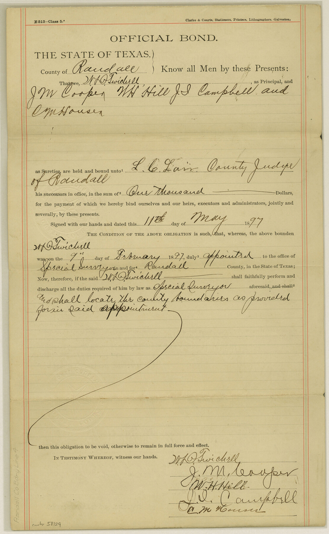
Randall County Boundary File 4
[Bond Certificate; Certificate of Proceedings]
-
Map/Doc
58129
-
Collection
General Map Collection
-
Counties
Randall
-
Subjects
County Boundaries
-
Height x Width
14.4 x 8.9 inches
36.6 x 22.6 cm
Part of: General Map Collection
Correct map of the Chicago, Burlington and Quincy Rail Road and its principal connecting lines

Print $20.00
- Digital $50.00
Correct map of the Chicago, Burlington and Quincy Rail Road and its principal connecting lines
1881
Size 27.7 x 38.6 inches
Map/Doc 93956
Brewster County Working Sketch 35

Print $20.00
- Digital $50.00
Brewster County Working Sketch 35
1943
Size 21.0 x 19.4 inches
Map/Doc 67569
San Patricio County Rolled Sketch 27A

Print $40.00
- Digital $50.00
San Patricio County Rolled Sketch 27A
Size 50.4 x 38.5 inches
Map/Doc 9891
Brewster County Rolled Sketch 122

Print $20.00
- Digital $50.00
Brewster County Rolled Sketch 122
1974
Size 32.0 x 25.5 inches
Map/Doc 5297
Flight Mission No. DAG-18K, Frame 185, Matagorda County

Print $20.00
- Digital $50.00
Flight Mission No. DAG-18K, Frame 185, Matagorda County
1952
Size 16.2 x 15.9 inches
Map/Doc 86377
Flight Mission No. BRA-16M, Frame 148, Jefferson County

Print $20.00
- Digital $50.00
Flight Mission No. BRA-16M, Frame 148, Jefferson County
1953
Size 18.5 x 22.2 inches
Map/Doc 85754
Edwards County Working Sketch 27

Print $20.00
- Digital $50.00
Edwards County Working Sketch 27
1944
Size 27.7 x 23.9 inches
Map/Doc 68903
El Paso County Working Sketch 4

Print $20.00
- Digital $50.00
El Paso County Working Sketch 4
1916
Size 21.4 x 37.3 inches
Map/Doc 69026
Hudspeth County Sketch File 28

Print $20.00
- Digital $50.00
Hudspeth County Sketch File 28
1943
Size 15.3 x 21.4 inches
Map/Doc 11803
Val Verde County Rolled Sketch 60

Print $20.00
- Digital $50.00
Val Verde County Rolled Sketch 60
1951
Size 32.4 x 20.4 inches
Map/Doc 8127
San Jacinto County Working Sketch 1

Print $20.00
- Digital $50.00
San Jacinto County Working Sketch 1
Size 30.0 x 29.6 inches
Map/Doc 63714
Harris County Boundary File 39 (11)

Print $8.00
- Digital $50.00
Harris County Boundary File 39 (11)
Size 12.8 x 8.0 inches
Map/Doc 54335
You may also like
Presidio County Sketch File 77

Print $20.00
- Digital $50.00
Presidio County Sketch File 77
Size 21.8 x 17.9 inches
Map/Doc 11721
Wichita County

Print $20.00
- Digital $50.00
Wichita County
1924
Size 33.7 x 40.2 inches
Map/Doc 63123

Gonzales County Sketch File 10

Print $4.00
- Digital $50.00
Gonzales County Sketch File 10
1873
Size 8.4 x 5.2 inches
Map/Doc 24390
Starr County Rolled Sketch 44

Print $20.00
- Digital $50.00
Starr County Rolled Sketch 44
Size 38.0 x 46.0 inches
Map/Doc 9943
Robertson County Working Sketch 20

Print $40.00
- Digital $50.00
Robertson County Working Sketch 20
2005
Size 27.5 x 50.0 inches
Map/Doc 83583
Foard County Sketch File 21

Print $14.00
- Digital $50.00
Foard County Sketch File 21
Size 13.1 x 8.6 inches
Map/Doc 22839
[John S. Stephens Blk. S-2, J. A. Oden Blk. 1, Lgs. 174-176]
![90188, [John S. Stephens Blk. S-2, J. A. Oden Blk. 1, Lgs. 174-176], Twichell Survey Records](https://historictexasmaps.com/wmedia_w700/maps/90188-1.tif.jpg)
Print $20.00
- Digital $50.00
[John S. Stephens Blk. S-2, J. A. Oden Blk. 1, Lgs. 174-176]
1913
Size 23.5 x 27.0 inches
Map/Doc 90188
Stonewall County Rolled Sketch 25

Print $20.00
- Digital $50.00
Stonewall County Rolled Sketch 25
1952
Size 27.8 x 22.1 inches
Map/Doc 7873
Menard County Working Sketch 16

Print $40.00
- Digital $50.00
Menard County Working Sketch 16
1946
Size 49.1 x 39.1 inches
Map/Doc 70963
Dickens County Sketch File 18a

Print $20.00
- Digital $50.00
Dickens County Sketch File 18a
Size 17.6 x 19.4 inches
Map/Doc 11322
Crockett County Working Sketch 91

Print $20.00
- Digital $50.00
Crockett County Working Sketch 91
1978
Size 32.8 x 32.4 inches
Map/Doc 68424