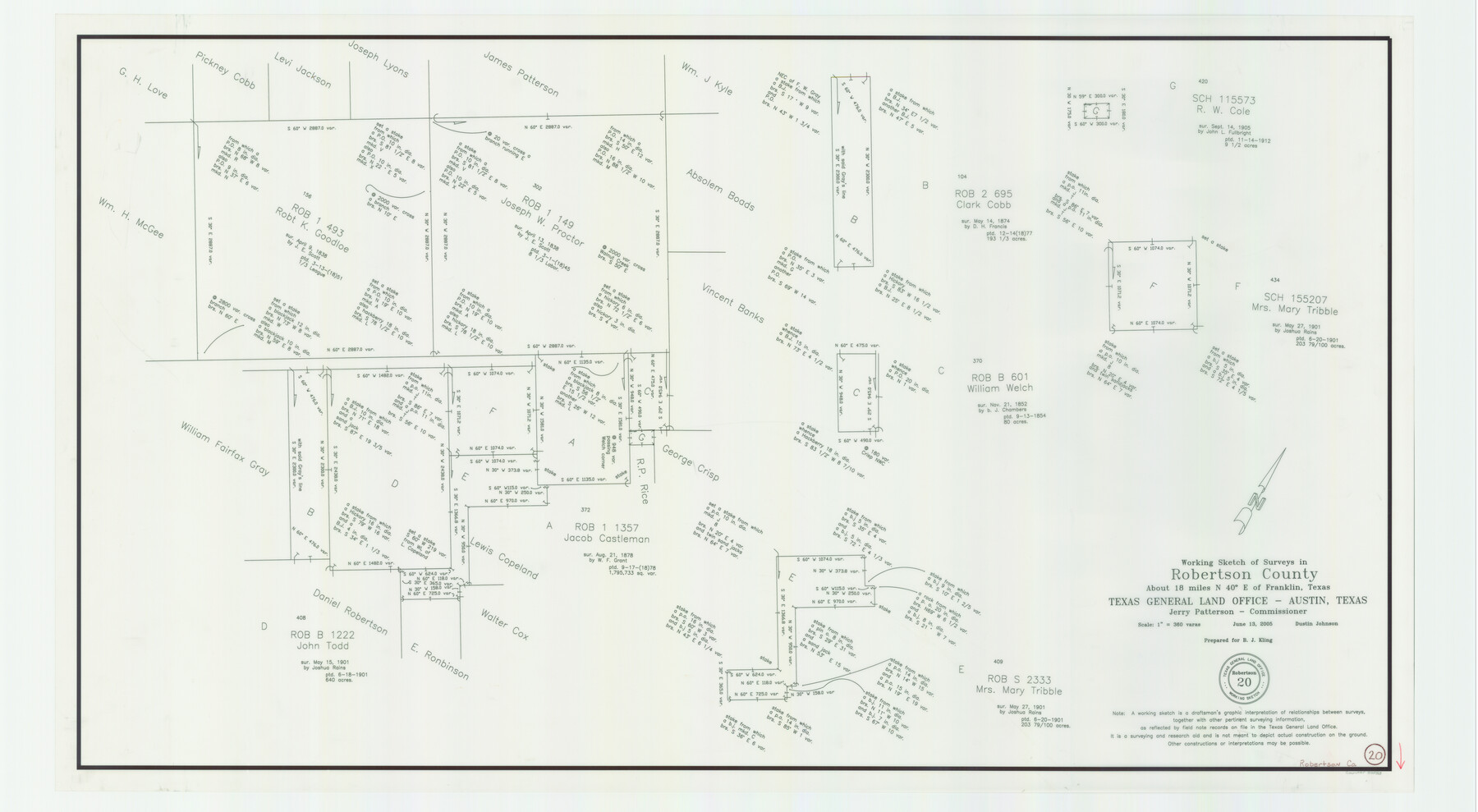
Robertson County Working Sketch 20
-
Map/Doc
83583
-
Collection
General Map Collection
-
Object Dates
6/13/2005 (Creation Date)
-
People and Organizations
Dustin Johnson (Draftsman)
-
Counties
Robertson
-
Subjects
Surveying Working Sketch
-
Height x Width
27.5 x 50.0 inches
69.9 x 127.0 cm
-
Scale
1" = 360 varas
-
Comments
Located about 18 miles North 40 degrees East of Franklin, Texas.
Part of: General Map Collection
Texas Coordinate File 7

Print $4.00
- Digital $50.00
Texas Coordinate File 7
Size 11.3 x 8.8 inches
Map/Doc 75316
Flight Mission No. DCL-6C, Frame 30, Kenedy County

Print $20.00
- Digital $50.00
Flight Mission No. DCL-6C, Frame 30, Kenedy County
1943
Size 18.8 x 22.3 inches
Map/Doc 85887
Donley County Sketch File 13

Print $8.00
- Digital $50.00
Donley County Sketch File 13
1881
Size 5.8 x 9.0 inches
Map/Doc 21249
Rio Grande, Hargill Sheet

Print $20.00
- Digital $50.00
Rio Grande, Hargill Sheet
1935
Size 37.1 x 38.1 inches
Map/Doc 65121
Palo Pinto County Rolled Sketch 4

Print $20.00
- Digital $50.00
Palo Pinto County Rolled Sketch 4
Size 15.9 x 23.2 inches
Map/Doc 7189
Andrews County Rolled Sketch 40

Print $20.00
- Digital $50.00
Andrews County Rolled Sketch 40
Size 37.2 x 23.0 inches
Map/Doc 77180
Liberty County Rolled Sketch 15

Print $20.00
- Digital $50.00
Liberty County Rolled Sketch 15
2015
Size 36.1 x 24.3 inches
Map/Doc 94022
Galveston County Sketch File 73g

Print $20.00
- Digital $50.00
Galveston County Sketch File 73g
Size 32.1 x 41.2 inches
Map/Doc 10460
Gonzales County Boundary File 2

Print $7.00
- Digital $50.00
Gonzales County Boundary File 2
Size 14.4 x 9.0 inches
Map/Doc 53829
Flight Mission No. CGI-4N, Frame 159, Cameron County

Print $20.00
- Digital $50.00
Flight Mission No. CGI-4N, Frame 159, Cameron County
1955
Size 18.7 x 22.2 inches
Map/Doc 84667
Lamb County Sketch File A

Print $20.00
- Digital $50.00
Lamb County Sketch File A
1902
Size 30.8 x 38.7 inches
Map/Doc 10518
Lee County Boundary File 2

Print $25.00
- Digital $50.00
Lee County Boundary File 2
Size 14.2 x 8.6 inches
Map/Doc 56269
You may also like
Ellis Addition to the City of Lubbock, Being a Subdivision of a Part of the SW/4 of SW/4 Sec. 4, Blk. A

Print $3.00
- Digital $50.00
Ellis Addition to the City of Lubbock, Being a Subdivision of a Part of the SW/4 of SW/4 Sec. 4, Blk. A
1952
Size 9.4 x 11.9 inches
Map/Doc 92709
Tom Green County Sketch File 88

Print $8.00
- Digital $50.00
Tom Green County Sketch File 88
1990
Size 11.5 x 8.9 inches
Map/Doc 38266
Liberty County Working Sketch 4

Print $20.00
- Digital $50.00
Liberty County Working Sketch 4
1901
Size 16.1 x 20.2 inches
Map/Doc 70463
[T. & P. Blocks 32-34, Township 3N]
![90560, [T. & P. Blocks 32-34, Township 3N], Twichell Survey Records](https://historictexasmaps.com/wmedia_w700/maps/90560-1.tif.jpg)
Print $20.00
- Digital $50.00
[T. & P. Blocks 32-34, Township 3N]
Size 27.7 x 20.2 inches
Map/Doc 90560
Aransas County Sketch File 21a

Print $4.00
- Digital $50.00
Aransas County Sketch File 21a
Size 14.2 x 8.7 inches
Map/Doc 13158
Montgomery County Sketch File 36

Print $40.00
- Digital $50.00
Montgomery County Sketch File 36
1953
Size 51.7 x 34.9 inches
Map/Doc 10551
McMullen County Rolled Sketch 11

Print $20.00
- Digital $50.00
McMullen County Rolled Sketch 11
Size 32.2 x 22.3 inches
Map/Doc 6728
Presidio County Boundary File 3

Print $33.00
- Digital $50.00
Presidio County Boundary File 3
Size 14.1 x 8.5 inches
Map/Doc 58058
Roberts County Working Sketch 11

Print $40.00
- Digital $50.00
Roberts County Working Sketch 11
1966
Size 57.6 x 38.6 inches
Map/Doc 63537
Concho County Rolled Sketch 7

Print $20.00
- Digital $50.00
Concho County Rolled Sketch 7
1950
Size 36.9 x 35.7 inches
Map/Doc 8652
Childress County Sketch File 1

Print $16.00
- Digital $50.00
Childress County Sketch File 1
1877
Size 12.8 x 8.3 inches
Map/Doc 18235
Lee County Working Sketch 10

Print $20.00
- Digital $50.00
Lee County Working Sketch 10
1979
Size 32.6 x 35.4 inches
Map/Doc 70389