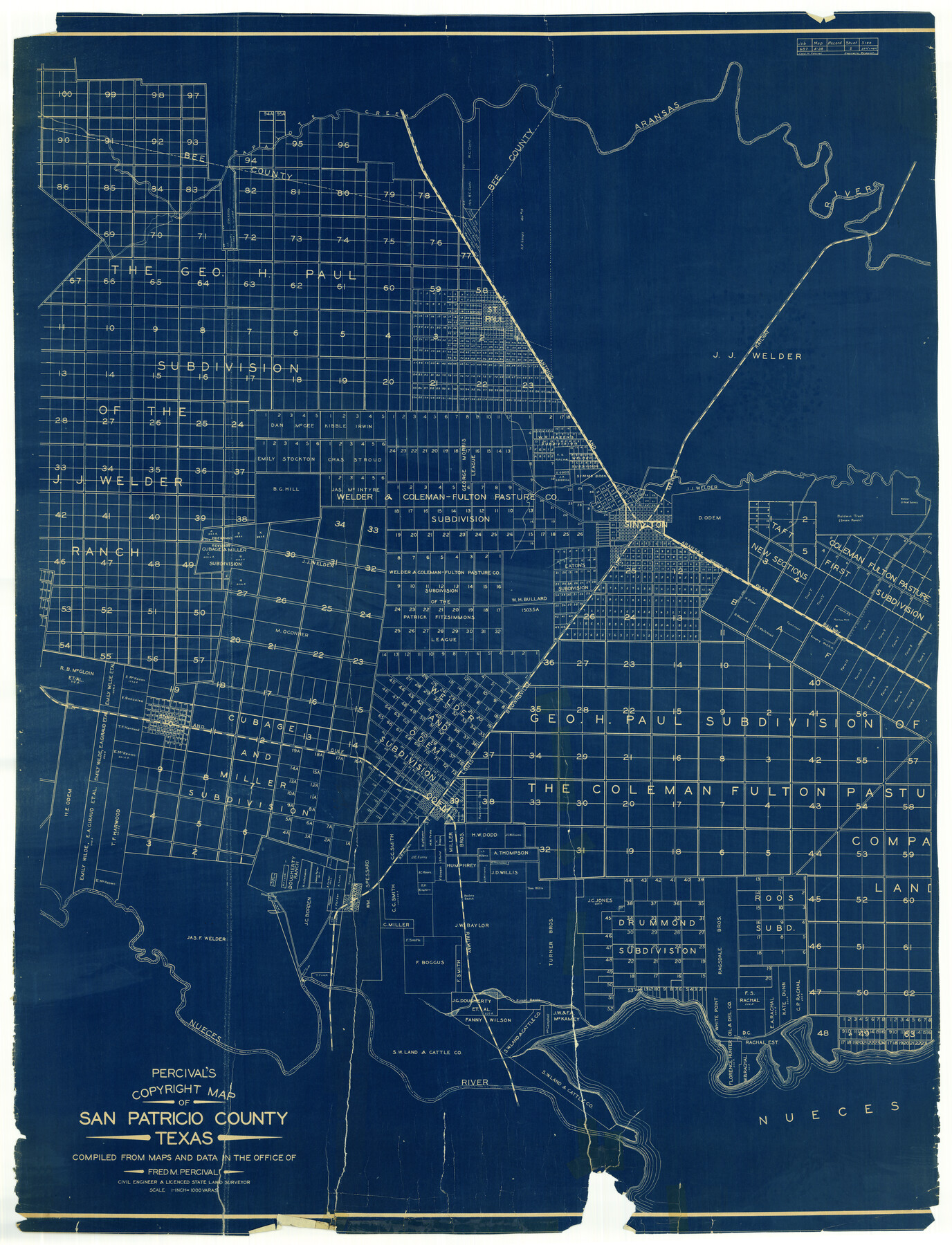
San Patricio County Rolled Sketch 27A
Percival's Copyright Map of San Patricio County, Texas
-
Map/Doc
9891
-
Collection
General Map Collection
-
People and Organizations
Fred M. Percival (Surveyor/Engineer)
-
Counties
San Patricio
-
Subjects
Surveying Rolled Sketch
-
Height x Width
50.4 x 38.5 inches
128.0 x 97.8 cm
-
Medium
blueprint/diazo
Part of: General Map Collection
Stephens County Working Sketch 9

Print $20.00
- Digital $50.00
Stephens County Working Sketch 9
1920
Size 16.3 x 14.6 inches
Map/Doc 63952
Flight Mission No. CUG-3P, Frame 192, Kleberg County

Print $20.00
- Digital $50.00
Flight Mission No. CUG-3P, Frame 192, Kleberg County
1956
Size 18.4 x 22.2 inches
Map/Doc 86296
Johnson County Sketch File 8

Print $6.00
- Digital $50.00
Johnson County Sketch File 8
1859
Size 8.0 x 9.7 inches
Map/Doc 28440
Aransas County Sketch File 21d

Print $4.00
- Digital $50.00
Aransas County Sketch File 21d
Size 14.4 x 8.9 inches
Map/Doc 13164
Nueces County Sketch File 79

Print $16.00
- Digital $50.00
Nueces County Sketch File 79
Size 11.0 x 8.5 inches
Map/Doc 33096
Harris County Working Sketch 118

Print $20.00
- Digital $50.00
Harris County Working Sketch 118
1984
Size 24.1 x 34.8 inches
Map/Doc 66010
Galveston Bay and Approaches

Print $20.00
- Digital $50.00
Galveston Bay and Approaches
1933
Size 46.0 x 34.9 inches
Map/Doc 69874
Motley County Boundary File 2e

Print $40.00
- Digital $50.00
Motley County Boundary File 2e
Size 29.4 x 96.1 inches
Map/Doc 57561
[Plat of Colorado River Survey, McCulloch County]
![2462, [Plat of Colorado River Survey, McCulloch County], General Map Collection](https://historictexasmaps.com/wmedia_w700/maps/2462-1.tif.jpg)
Print $40.00
- Digital $50.00
[Plat of Colorado River Survey, McCulloch County]
1918
Size 40.3 x 159.2 inches
Map/Doc 2462

Cherokee County Working Sketch 3

Print $20.00
- Digital $50.00
Cherokee County Working Sketch 3
1934
Size 29.6 x 42.7 inches
Map/Doc 67958
Donley County Sketch File 27

Print $4.00
- Digital $50.00
Donley County Sketch File 27
Size 7.7 x 12.1 inches
Map/Doc 21264
You may also like
Flight Mission No. DAG-24K, Frame 138, Matagorda County

Print $20.00
- Digital $50.00
Flight Mission No. DAG-24K, Frame 138, Matagorda County
1953
Size 18.4 x 15.8 inches
Map/Doc 86556
General Highway Map, Duval County, Texas

Print $20.00
General Highway Map, Duval County, Texas
1961
Size 18.1 x 24.5 inches
Map/Doc 79449
Upshur County Working Sketch 17

Print $40.00
- Digital $50.00
Upshur County Working Sketch 17
1997
Size 48.4 x 37.1 inches
Map/Doc 69575
Map of Hale County

Print $20.00
- Digital $50.00
Map of Hale County
1900
Size 47.8 x 38.6 inches
Map/Doc 66847
Webb County Working Sketch 90

Print $20.00
- Digital $50.00
Webb County Working Sketch 90
1982
Size 26.9 x 25.5 inches
Map/Doc 72457
Orange County NRC Article 33.136 Sketch 6

Print $42.00
Orange County NRC Article 33.136 Sketch 6
2025
Map/Doc 97430
Ellis County Sketch File 6

Print $24.00
- Digital $50.00
Ellis County Sketch File 6
Size 12.3 x 8.2 inches
Map/Doc 21836
Map of Webb County

Print $20.00
- Digital $50.00
Map of Webb County
1895
Size 34.8 x 27.0 inches
Map/Doc 4132
Wharton County

Print $40.00
- Digital $50.00
Wharton County
1894
Size 55.8 x 36.0 inches
Map/Doc 87352
Jeff Davis County Sketch File 20

Print $56.00
- Digital $50.00
Jeff Davis County Sketch File 20
1923
Size 11.2 x 8.8 inches
Map/Doc 27978
Map of Tyler County

Print $20.00
- Digital $50.00
Map of Tyler County
1897
Size 42.0 x 37.5 inches
Map/Doc 16907
T. & N. O. R.R. Jefferson Co. North

Print $20.00
- Digital $50.00
T. & N. O. R.R. Jefferson Co. North
1917
Size 13.4 x 33.5 inches
Map/Doc 64056