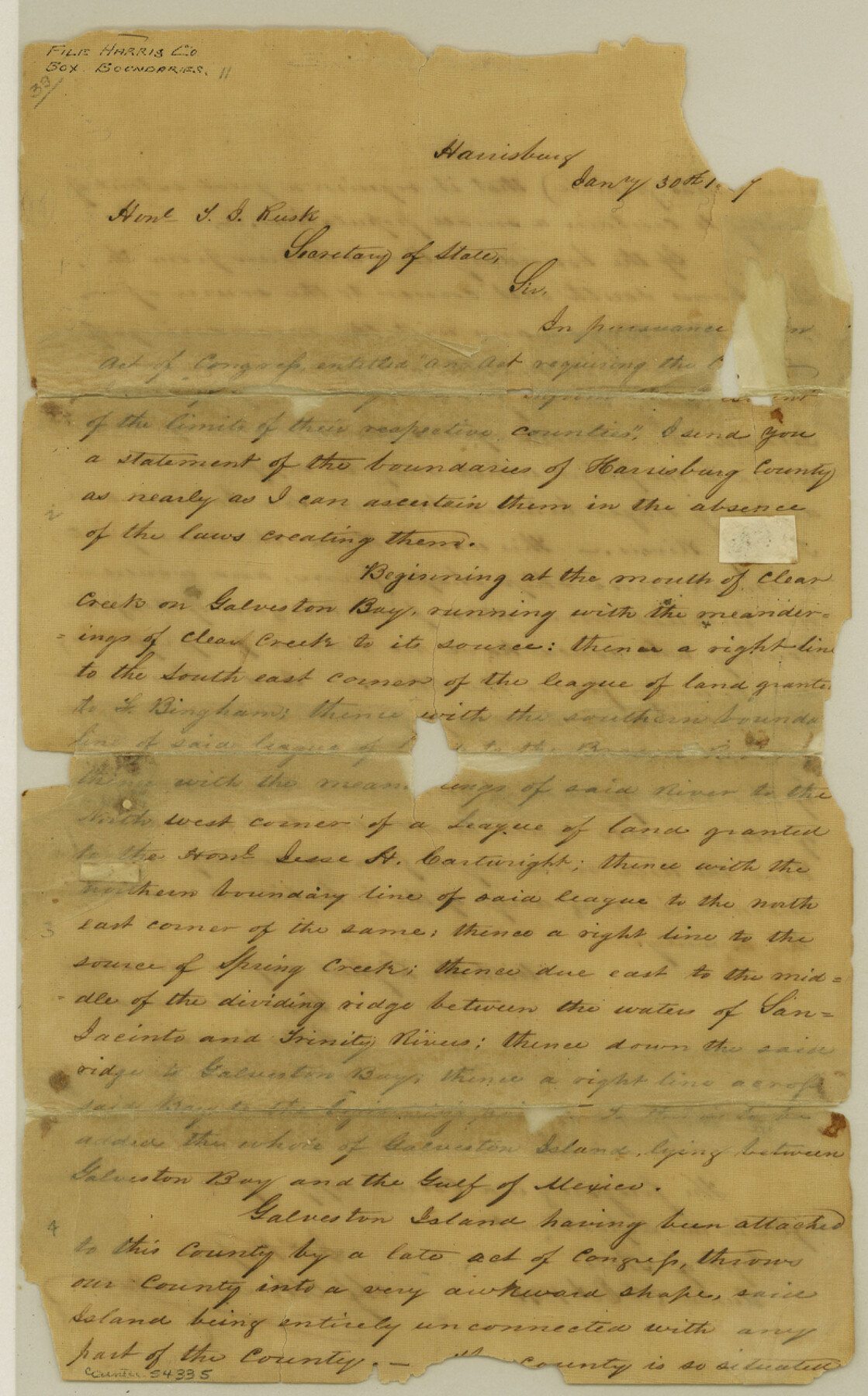
Harris County Boundary File 39 (11)
County Boundaries Harris County Report of Chief Justice on the boundary line of Harris Co.
-
Map/Doc
54335
-
Collection
General Map Collection
-
Counties
Harris
-
Subjects
County Boundaries
-
Height x Width
12.8 x 8.0 inches
32.5 x 20.3 cm
Part of: General Map Collection
Flight Mission No. DCL-6C, Frame 27, Kenedy County

Print $20.00
- Digital $50.00
Flight Mission No. DCL-6C, Frame 27, Kenedy County
1943
Size 18.7 x 22.4 inches
Map/Doc 85884
Brewster County Rolled Sketch 100

Print $133.00
- Digital $50.00
Brewster County Rolled Sketch 100
1893
Size 10.1 x 15.4 inches
Map/Doc 43055
Karnes County Working Sketch 1

Print $20.00
- Digital $50.00
Karnes County Working Sketch 1
1933
Size 19.4 x 15.3 inches
Map/Doc 66649
Controlled Mosaic by Jack Amman Photogrammetric Engineers, Inc - Sheet 13

Print $20.00
- Digital $50.00
Controlled Mosaic by Jack Amman Photogrammetric Engineers, Inc - Sheet 13
1954
Size 20.0 x 24.0 inches
Map/Doc 83457
Harris County Working Sketch 47

Print $40.00
- Digital $50.00
Harris County Working Sketch 47
1942
Size 39.5 x 51.9 inches
Map/Doc 65939
Flight Mission No. DIX-5P, Frame 151, Aransas County

Print $20.00
- Digital $50.00
Flight Mission No. DIX-5P, Frame 151, Aransas County
1956
Size 17.8 x 18.2 inches
Map/Doc 83813
Flight Mission No. DIX-10P, Frame 82, Aransas County

Print $20.00
- Digital $50.00
Flight Mission No. DIX-10P, Frame 82, Aransas County
1956
Size 18.8 x 22.4 inches
Map/Doc 83943
Fort Bend County Working Sketch 3

Print $20.00
- Digital $50.00
Fort Bend County Working Sketch 3
1897
Size 26.8 x 24.6 inches
Map/Doc 69209
Hardeman County Working Sketch 13

Print $20.00
- Digital $50.00
Hardeman County Working Sketch 13
1966
Size 35.8 x 45.7 inches
Map/Doc 63394
Map of Llano County

Print $20.00
- Digital $50.00
Map of Llano County
1871
Size 17.0 x 20.5 inches
Map/Doc 3825
Foard County Rolled Sketch 13

Print $20.00
- Digital $50.00
Foard County Rolled Sketch 13
1958
Size 25.2 x 31.4 inches
Map/Doc 5887
Flight Mission No. DQN-2K, Frame 68, Calhoun County

Print $20.00
- Digital $50.00
Flight Mission No. DQN-2K, Frame 68, Calhoun County
1953
Size 18.6 x 22.2 inches
Map/Doc 84260
You may also like
Brooks County Boundary File 1b

Print $20.00
- Digital $50.00
Brooks County Boundary File 1b
Size 42.2 x 6.6 inches
Map/Doc 50837
Travis County Rolled Sketch 23

Print $20.00
- Digital $50.00
Travis County Rolled Sketch 23
1941
Size 30.5 x 37.7 inches
Map/Doc 8024
Crockett County Working Sketch 71

Print $20.00
- Digital $50.00
Crockett County Working Sketch 71
1963
Size 38.7 x 32.7 inches
Map/Doc 68404
Motley County Sketch File 9a (N)

Print $4.00
- Digital $50.00
Motley County Sketch File 9a (N)
1885
Size 14.2 x 8.6 inches
Map/Doc 32024
Gregg County Sketch File 3

Print $6.00
- Digital $50.00
Gregg County Sketch File 3
1931
Size 11.2 x 8.7 inches
Map/Doc 24569
Hardin County Rolled Sketch TMH

Print $46.00
- Digital $50.00
Hardin County Rolled Sketch TMH
1936
Size 25.7 x 23.9 inches
Map/Doc 6093
Flight Mission No. BRA-3M, Frame 121, Jefferson County

Print $20.00
- Digital $50.00
Flight Mission No. BRA-3M, Frame 121, Jefferson County
1953
Size 18.8 x 22.3 inches
Map/Doc 85395
[Plat of Location and Right of Way from El Paso, Tex. To New Mexico Line, Rio Grande and El Paso R. R.]
![64082, [Plat of Location and Right of Way from El Paso, Tex. To New Mexico Line, Rio Grande and El Paso R. R.], General Map Collection](https://historictexasmaps.com/wmedia_w700/maps/64082.tif.jpg)
Print $40.00
- Digital $50.00
[Plat of Location and Right of Way from El Paso, Tex. To New Mexico Line, Rio Grande and El Paso R. R.]
Size 23.8 x 122.6 inches
Map/Doc 64082
Chambers County Rolled Sketch 34

Print $40.00
- Digital $50.00
Chambers County Rolled Sketch 34
1956
Size 50.0 x 85.8 inches
Map/Doc 73571

Glasscock County Boundary File 2

Print $14.00
- Digital $50.00
Glasscock County Boundary File 2
Size 14.4 x 9.1 inches
Map/Doc 53790
Val Verde County Sketch File A4

Print $10.00
- Digital $50.00
Val Verde County Sketch File A4
1897
Size 9.2 x 8.5 inches
Map/Doc 39046