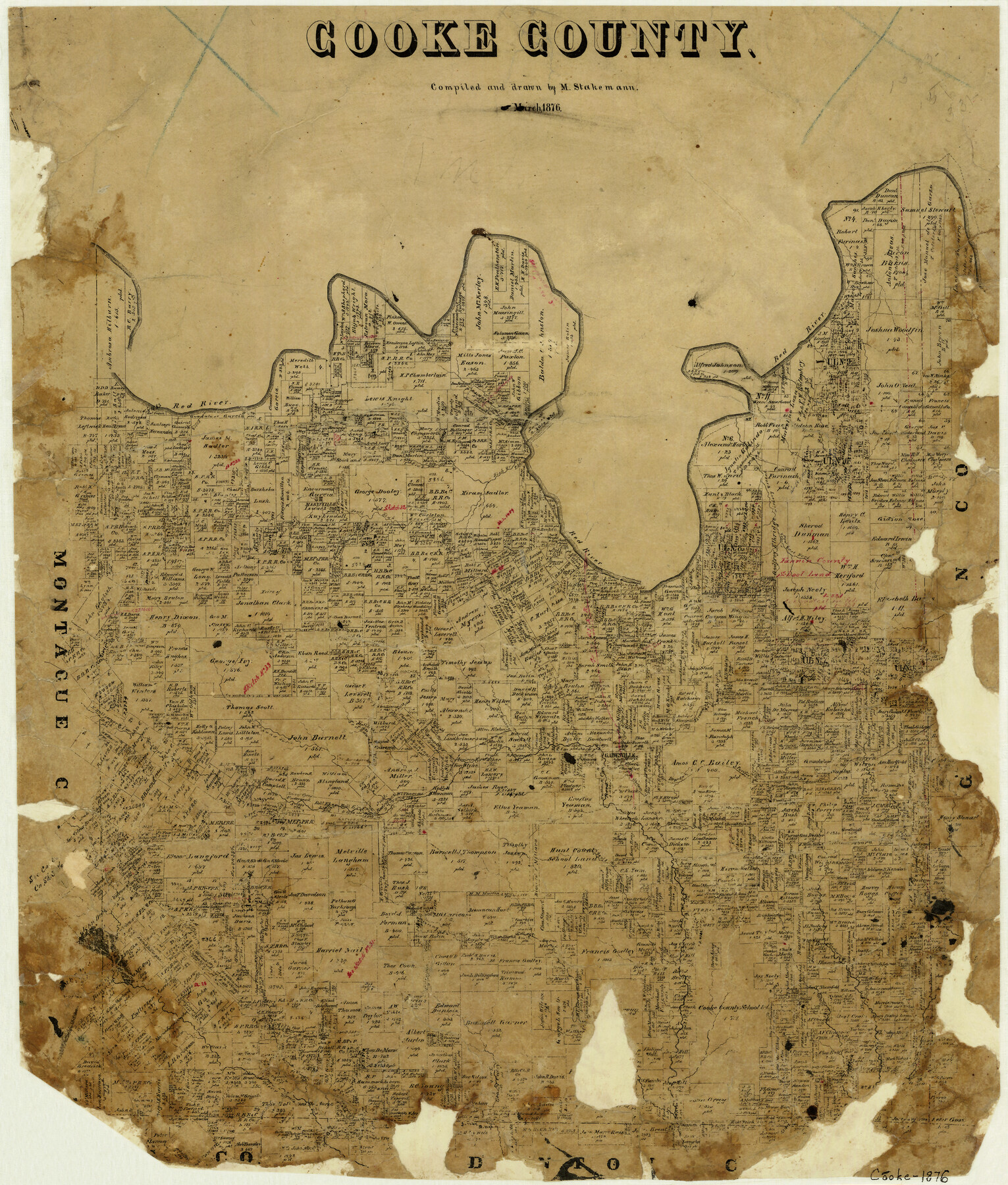
Cooke County
-
Map/Doc
3441
-
Collection
General Map Collection
-
Object Dates
3/1876 (Creation Date)
-
People and Organizations
Max Stakemann (Draftsman)
-
Counties
Cooke
-
Subjects
County
-
Height x Width
21.3 x 18.0 inches
54.1 x 45.7 cm
-
Features
D&P
GC&SF
Marysville
Gainsville
Red River
Brushy Creek
Hickory Creek
East Fork of Hickory Creek
Fish Creek
South Fish Creek
Montague Creek
Pecan Creek
Brown Creek
Indian Creek
Part of: General Map Collection
Stephens County Working Sketch 39

Print $20.00
- Digital $50.00
Stephens County Working Sketch 39
1995
Size 25.5 x 27.1 inches
Map/Doc 63982
Culberson County Sketch File 2

Print $20.00
- Digital $50.00
Culberson County Sketch File 2
1882
Size 28.9 x 36.4 inches
Map/Doc 11261
Crane County Working Sketch 7

Print $20.00
- Digital $50.00
Crane County Working Sketch 7
1929
Size 33.6 x 23.2 inches
Map/Doc 68284
Map of Menard County

Print $20.00
- Digital $50.00
Map of Menard County
1871
Size 18.5 x 23.3 inches
Map/Doc 3872
[Surveys near the Medina River, Bexar District]
![230, [Surveys near the Medina River, Bexar District], General Map Collection](https://historictexasmaps.com/wmedia_w700/maps/230.tif.jpg)
Print $2.00
- Digital $50.00
[Surveys near the Medina River, Bexar District]
1847
Size 13.1 x 8.0 inches
Map/Doc 230
Bell County Sketch File 17

Print $4.00
- Digital $50.00
Bell County Sketch File 17
Size 8.1 x 9.1 inches
Map/Doc 14398
St. Louis Southwestern Railway of Texas

Print $20.00
- Digital $50.00
St. Louis Southwestern Railway of Texas
1900
Size 21.6 x 29.9 inches
Map/Doc 64446
[Redfish Bay, Aransas Pass, and part of Mustang Island]
![83009, [Redfish Bay, Aransas Pass, and part of Mustang Island], General Map Collection](https://historictexasmaps.com/wmedia_w700/maps/83009.tif.jpg)
Print $40.00
- Digital $50.00
[Redfish Bay, Aransas Pass, and part of Mustang Island]
1930
Size 51.0 x 46.5 inches
Map/Doc 83009
Gonzales County

Print $40.00
- Digital $50.00
Gonzales County
1986
Size 39.9 x 52.0 inches
Map/Doc 77292
Harrison County Working Sketch 17

Print $20.00
- Digital $50.00
Harrison County Working Sketch 17
1969
Size 38.1 x 38.0 inches
Map/Doc 66037
Franklin County Sketch File 17

Print $16.00
- Digital $50.00
Franklin County Sketch File 17
1951
Size 11.3 x 8.8 inches
Map/Doc 23026
San Jacinto County Rolled Sketch 14

Print $20.00
- Digital $50.00
San Jacinto County Rolled Sketch 14
1998
Size 29.0 x 40.6 inches
Map/Doc 7567
You may also like
Bell County Sketch File 23a

Print $6.00
- Digital $50.00
Bell County Sketch File 23a
1873
Size 10.0 x 15.7 inches
Map/Doc 14416
The Absolem C. De La Plain League and Labor of Land

Print $20.00
- Digital $50.00
The Absolem C. De La Plain League and Labor of Land
2013
Size 30.0 x 24.0 inches
Map/Doc 93425
Potter County Boundary File 1a

Print $10.00
- Digital $50.00
Potter County Boundary File 1a
Size 14.1 x 8.8 inches
Map/Doc 57943
Kleberg County Aerial Photograph Index Sheet 7

Print $20.00
- Digital $50.00
Kleberg County Aerial Photograph Index Sheet 7
1956
Size 24.0 x 20.1 inches
Map/Doc 83724
Hutchinson County Sketch File 29

Print $20.00
- Digital $50.00
Hutchinson County Sketch File 29
Size 16.7 x 20.8 inches
Map/Doc 11818
Erath County Working Sketch 19

Print $20.00
- Digital $50.00
Erath County Working Sketch 19
1963
Size 30.1 x 27.6 inches
Map/Doc 69100
Harrison County Working Sketch 10

Print $20.00
- Digital $50.00
Harrison County Working Sketch 10
1957
Size 25.8 x 24.6 inches
Map/Doc 66030
Somervell County Sketch File 5

Print $95.00
- Digital $50.00
Somervell County Sketch File 5
1871
Size 8.8 x 7.7 inches
Map/Doc 36802
Bird's Eye View of Corpus Christi

Print $20.00
Bird's Eye View of Corpus Christi
1887
Size 21.4 x 28.0 inches
Map/Doc 94113
Leon County Working Sketch 16

Print $20.00
- Digital $50.00
Leon County Working Sketch 16
1958
Size 26.9 x 30.7 inches
Map/Doc 70415
Texas, Matagorda Bay, Vicinity of Trespalacios Bay

Print $40.00
- Digital $50.00
Texas, Matagorda Bay, Vicinity of Trespalacios Bay
1933
Size 49.0 x 32.6 inches
Map/Doc 69988