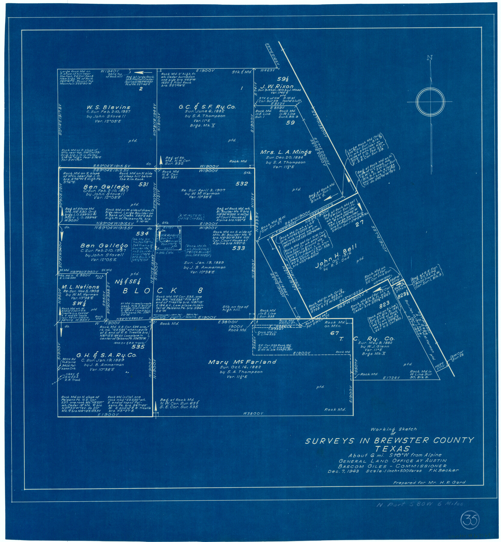
Brewster County Working Sketch 35
-
Map/Doc
67569
-
Collection
General Map Collection
-
Object Dates
12/7/1943 (Creation Date)
-
People and Organizations
F.H. Becker (Draftsman)
-
Counties
Brewster
-
Subjects
Surveying Working Sketch
-
Height x Width
21.0 x 19.4 inches
53.3 x 49.3 cm
-
Scale
1" = 500 varas
Part of: General Map Collection
La Salle County

Print $20.00
- Digital $50.00
La Salle County
1879
Size 27.4 x 23.6 inches
Map/Doc 3800
Flight Mission No. DAG-21K, Frame 43, Matagorda County

Print $20.00
- Digital $50.00
Flight Mission No. DAG-21K, Frame 43, Matagorda County
1952
Size 18.9 x 22.6 inches
Map/Doc 86410
Location of the Southern Kansas Railway of Texas

Print $40.00
- Digital $50.00
Location of the Southern Kansas Railway of Texas
1887
Size 18.6 x 106.9 inches
Map/Doc 64181
Liberty County Working Sketch 16

Print $20.00
- Digital $50.00
Liberty County Working Sketch 16
1936
Size 24.1 x 34.7 inches
Map/Doc 70475
El Paso County Working Sketch 18

Print $40.00
- Digital $50.00
El Paso County Working Sketch 18
1960
Size 74.4 x 16.1 inches
Map/Doc 69040
Newton County Sketch File 5

Print $8.00
- Digital $50.00
Newton County Sketch File 5
Size 8.2 x 12.8 inches
Map/Doc 32368
Township 9 South Range 13 West, South Western District, Louisiana

Print $20.00
- Digital $50.00
Township 9 South Range 13 West, South Western District, Louisiana
1858
Size 19.8 x 24.8 inches
Map/Doc 65852
Jefferson County Working Sketch 5

Print $20.00
- Digital $50.00
Jefferson County Working Sketch 5
1930
Size 32.7 x 21.8 inches
Map/Doc 66548
Schleicher County Sketch File 3

Print $20.00
- Digital $50.00
Schleicher County Sketch File 3
Size 28.1 x 19.9 inches
Map/Doc 12295
Hays County Sketch File 22

Print $4.00
- Digital $50.00
Hays County Sketch File 22
Size 8.4 x 7.3 inches
Map/Doc 26249
Burleson County Working Sketch 15

Print $20.00
- Digital $50.00
Burleson County Working Sketch 15
1980
Size 15.0 x 21.1 inches
Map/Doc 67734
Hutchinson County Working Sketch 18

Print $20.00
- Digital $50.00
Hutchinson County Working Sketch 18
1956
Size 31.4 x 18.3 inches
Map/Doc 66378
You may also like

Morris County Sketch File 5

Print $20.00
- Digital $50.00
Morris County Sketch File 5
Size 21.4 x 11.6 inches
Map/Doc 42132
Leon County Sketch File 35-1

Print $28.00
- Digital $50.00
Leon County Sketch File 35-1
1966
Size 14.1 x 8.6 inches
Map/Doc 29836

Culberson County Rolled Sketch 64

Print $20.00
- Digital $50.00
Culberson County Rolled Sketch 64
1987
Size 24.3 x 19.4 inches
Map/Doc 5680
Lee County Working Sketch 19

Print $20.00
- Digital $50.00
Lee County Working Sketch 19
1991
Size 33.1 x 20.1 inches
Map/Doc 70398
[I. & G. N. Block 1]
![91592, [I. & G. N. Block 1], Twichell Survey Records](https://historictexasmaps.com/wmedia_w700/maps/91592-1.tif.jpg)
Print $20.00
- Digital $50.00
[I. & G. N. Block 1]
Size 17.2 x 18.1 inches
Map/Doc 91592
A map of the Anthracite Coal Fields of Pennsylvania embracing all of Schuylkill County and parts of Carbon, Luzerne, Columbia, Northumberland, Dauphin, and Lebanon Counties

Print $20.00
- Digital $50.00
A map of the Anthracite Coal Fields of Pennsylvania embracing all of Schuylkill County and parts of Carbon, Luzerne, Columbia, Northumberland, Dauphin, and Lebanon Counties
1863
Size 27.1 x 39.3 inches
Map/Doc 94054
Hood County Sketch File 21

Print $12.00
- Digital $50.00
Hood County Sketch File 21
1873
Size 7.8 x 6.7 inches
Map/Doc 26609
Llano County Sketch File 17

Print $20.00
- Digital $50.00
Llano County Sketch File 17
1949
Size 21.8 x 20.2 inches
Map/Doc 12012
Kent County Sketch File A

Print $4.00
- Digital $50.00
Kent County Sketch File A
Size 8.2 x 9.0 inches
Map/Doc 28821
State Reclamation Department - An Index Map

Print $40.00
- Digital $50.00
State Reclamation Department - An Index Map
1930
Size 50.1 x 31.8 inches
Map/Doc 65267