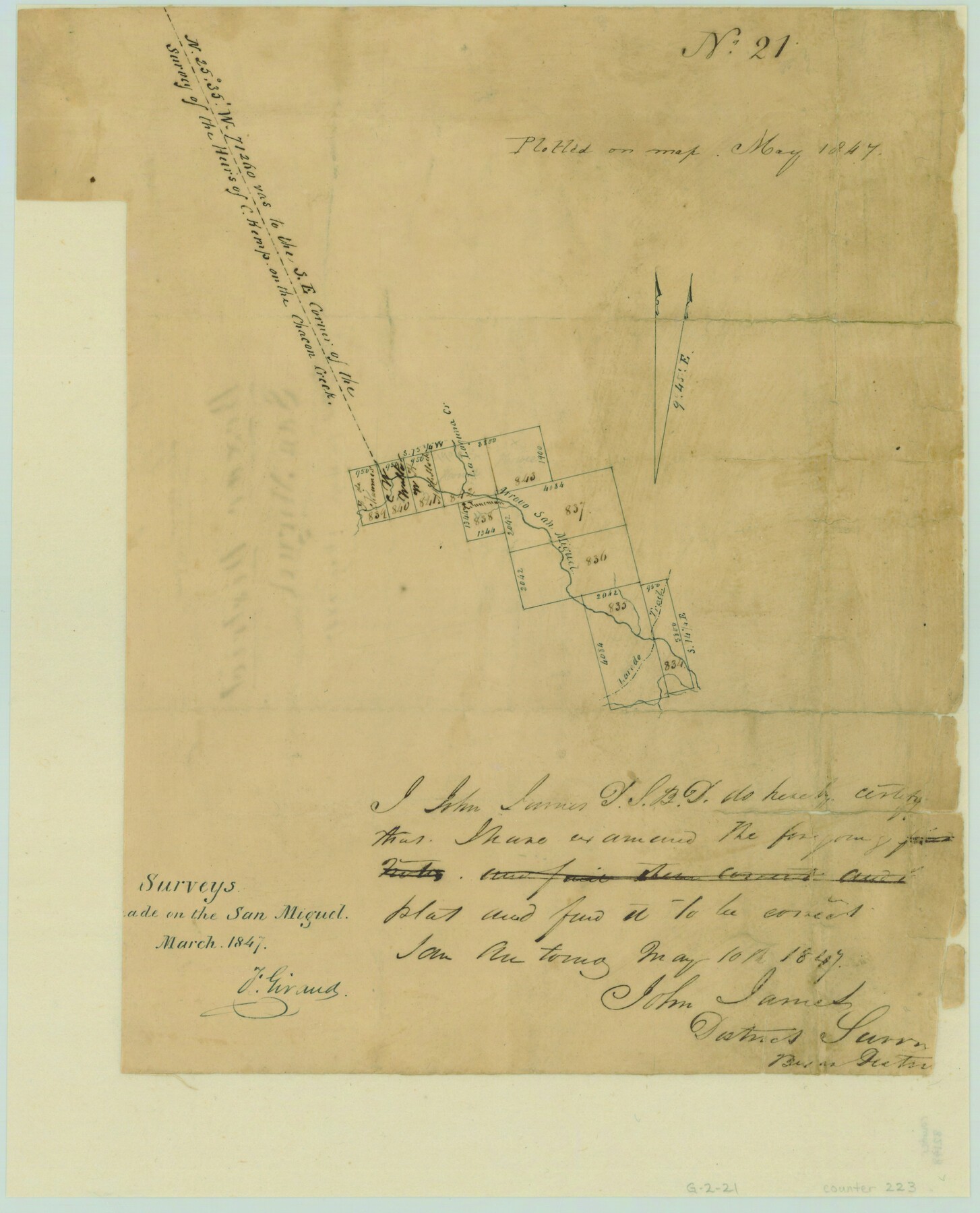
Surveys made on the San Miguel. March 1847
Atlas G, Page 2, Sketch 21 (G-2-21)
G-2-21
-
Map/Doc
223
-
Collection
General Map Collection
-
Object Dates
1847 (Creation Date)
-
People and Organizations
John James (Surveyor/Engineer)
T. Giraud (Draftsman)
-
Counties
Atascosa McMullen
-
Subjects
Atlas
-
Height x Width
10.4 x 8.4 inches
26.4 x 21.3 cm
-
Medium
paper, manuscript
-
Comments
Conserved in 2004.
-
Features
Arroyo San Miguel
Laredo Trail
Part of: General Map Collection
Controlled Mosaic by Jack Amman Photogrammetric Engineers, Inc - Sheet 47

Print $20.00
- Digital $50.00
Controlled Mosaic by Jack Amman Photogrammetric Engineers, Inc - Sheet 47
1954
Size 20.0 x 24.0 inches
Map/Doc 83506
Panola County

Print $20.00
- Digital $50.00
Panola County
1947
Size 38.6 x 38.2 inches
Map/Doc 77390
Crockett County Sketch File 17

Print $10.00
- Digital $50.00
Crockett County Sketch File 17
1881
Size 12.7 x 8.0 inches
Map/Doc 19678
Webb County Working Sketch 85

Print $20.00
- Digital $50.00
Webb County Working Sketch 85
1981
Size 21.1 x 29.0 inches
Map/Doc 72452
Stonewall County Working Sketch 9

Print $20.00
- Digital $50.00
Stonewall County Working Sketch 9
1950
Size 27.9 x 34.1 inches
Map/Doc 62316
Runnels County Working Sketch 2

Print $20.00
- Digital $50.00
Runnels County Working Sketch 2
Size 19.8 x 29.4 inches
Map/Doc 63598
Schleicher County Sketch File 29

Print $44.00
- Digital $50.00
Schleicher County Sketch File 29
1940
Size 31.9 x 23.7 inches
Map/Doc 12306
Howard County Rolled Sketch 12A

Print $20.00
- Digital $50.00
Howard County Rolled Sketch 12A
1948
Size 23.3 x 13.9 inches
Map/Doc 6244
Williamson County Sketch File 13a

Print $4.00
- Digital $50.00
Williamson County Sketch File 13a
1871
Size 8.1 x 13.6 inches
Map/Doc 40330
Zavalla [sic] County
![16939, Zavalla [sic] County, General Map Collection](https://historictexasmaps.com/wmedia_w700/maps/16939.tif.jpg)
Print $20.00
- Digital $50.00
Zavalla [sic] County
1893
Size 44.5 x 46.3 inches
Map/Doc 16939
Galveston County NRC Article 33.136 Sketch 14

Print $20.00
- Digital $50.00
Galveston County NRC Article 33.136 Sketch 14
2002
Size 24.0 x 34.3 inches
Map/Doc 77045
Bastrop County

Print $20.00
- Digital $50.00
Bastrop County
1879
Size 21.5 x 19.5 inches
Map/Doc 3277
You may also like
Pecos County Rolled Sketch 114

Print $856.00
- Digital $50.00
Pecos County Rolled Sketch 114
1942
Size 11.0 x 15.4 inches
Map/Doc 48104
Galveston County Sketch File 11a

Print $4.00
- Digital $50.00
Galveston County Sketch File 11a
1877
Size 7.8 x 8.4 inches
Map/Doc 23376
Van Zandt County Sketch File 10

Print $4.00
- Digital $50.00
Van Zandt County Sketch File 10
1858
Size 6.2 x 8.0 inches
Map/Doc 39395
[Capitol League Lands in SE corner of Lamb County and along the north line of Lamb and Bailey]
![90244, [Capitol League Lands in SE corner of Lamb County and along the north line of Lamb and Bailey], Twichell Survey Records](https://historictexasmaps.com/wmedia_w700/maps/90244-1.tif.jpg)
Print $20.00
- Digital $50.00
[Capitol League Lands in SE corner of Lamb County and along the north line of Lamb and Bailey]
Size 27.7 x 19.7 inches
Map/Doc 90244
Blanco County Working Sketch 1

Print $20.00
- Digital $50.00
Blanco County Working Sketch 1
Size 31.1 x 17.4 inches
Map/Doc 76449
Brewster County Rolled Sketch 8

Print $40.00
- Digital $50.00
Brewster County Rolled Sketch 8
1878
Size 60.3 x 35.8 inches
Map/Doc 8467
Flight Mission No. DQN-1K, Frame 42, Calhoun County

Print $20.00
- Digital $50.00
Flight Mission No. DQN-1K, Frame 42, Calhoun County
1953
Size 18.5 x 18.7 inches
Map/Doc 84142
McMullen County Sketch File 24

Print $22.00
- Digital $50.00
McMullen County Sketch File 24
Size 8.7 x 12.6 inches
Map/Doc 31381

Starr County Boundary File 2

Print $8.00
- Digital $50.00
Starr County Boundary File 2
Size 11.0 x 7.4 inches
Map/Doc 58814
Coke County Rolled Sketch 19A

Print $20.00
- Digital $50.00
Coke County Rolled Sketch 19A
1954
Size 19.9 x 24.8 inches
Map/Doc 5520
Calhoun County Rolled Sketch 18

Print $20.00
- Digital $50.00
Calhoun County Rolled Sketch 18
1952
Size 12.2 x 11.9 inches
Map/Doc 5371