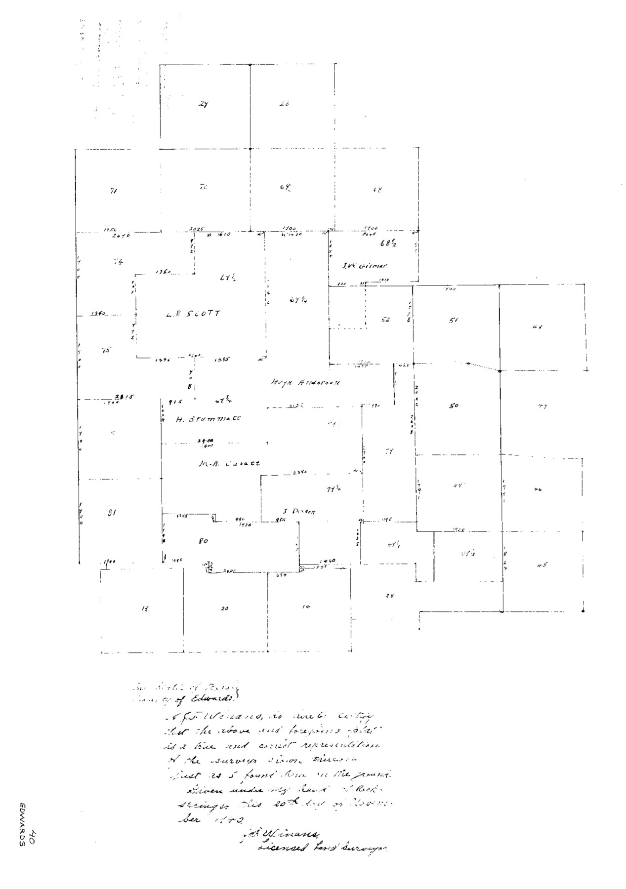
Edwards County Sketch File 40
[Sketch of surveys southeast from Rocksprings]
-
Map/Doc
11438
-
Collection
General Map Collection
-
Object Dates
11/20/1940 (Creation Date)
11/27/1940 (File Date)
-
People and Organizations
J.F. Winans (Surveyor/Engineer)
-
Counties
Edwards
-
Subjects
Surveying Sketch File
-
Height x Width
20.4 x 14.3 inches
51.8 x 36.3 cm
-
Medium
paper, photocopy
Part of: General Map Collection
Flight Mission No. BRE-1P, Frame 115, Nueces County

Print $20.00
- Digital $50.00
Flight Mission No. BRE-1P, Frame 115, Nueces County
1956
Size 18.4 x 22.2 inches
Map/Doc 86681
Harris County NRC Article 33.136 Sketch 21

Print $38.00
Harris County NRC Article 33.136 Sketch 21
2024
Map/Doc 97295
A Map of Texas published by the Dallas Morning News for the Texas Almanac and State Industrial Guide

A Map of Texas published by the Dallas Morning News for the Texas Almanac and State Industrial Guide
1936
Size 20.3 x 26.1 inches
Map/Doc 94293
Texas City Channel, Texas, Channel and Turning Basin Dredging - Sheet 3

Print $20.00
- Digital $50.00
Texas City Channel, Texas, Channel and Turning Basin Dredging - Sheet 3
1958
Size 28.4 x 40.6 inches
Map/Doc 61833
Trails made and routes used by the Fourth U.S. Cavalry under command of General R.S. Mackenzie in its operations against hostile indians in Texas, Indian-Territory (now Oklahoma), New Mexico and Old Mexico during the period of 1871-2-3-4 and 5

Print $20.00
- Digital $50.00
Trails made and routes used by the Fourth U.S. Cavalry under command of General R.S. Mackenzie in its operations against hostile indians in Texas, Indian-Territory (now Oklahoma), New Mexico and Old Mexico during the period of 1871-2-3-4 and 5
1927
Size 37.0 x 34.2 inches
Map/Doc 62973
Jasper County Sketch File 31

Print $20.00
- Digital $50.00
Jasper County Sketch File 31
Size 21.6 x 24.7 inches
Map/Doc 11852
Denton County Sketch File 29 1/2

Print $4.00
- Digital $50.00
Denton County Sketch File 29 1/2
Size 14.8 x 9.1 inches
Map/Doc 20758
La Salle County Working Sketch 24

Print $20.00
- Digital $50.00
La Salle County Working Sketch 24
1947
Size 20.9 x 31.2 inches
Map/Doc 70325
Brazoria County Rolled Sketch 35

Print $40.00
- Digital $50.00
Brazoria County Rolled Sketch 35
1934
Size 32.7 x 60.0 inches
Map/Doc 8459
San Saba County Boundary File 1

Print $4.00
- Digital $50.00
San Saba County Boundary File 1
Size 14.2 x 8.7 inches
Map/Doc 58575
Leon County Sketch File 24

Print $70.00
- Digital $50.00
Leon County Sketch File 24
1932
Size 11.2 x 8.7 inches
Map/Doc 29781
Culberson County Rolled Sketch 33

Print $20.00
- Digital $50.00
Culberson County Rolled Sketch 33
1937
Size 36.4 x 27.9 inches
Map/Doc 5658
You may also like
Flight Mission No. DQO-8K, Frame 10, Galveston County

Print $20.00
- Digital $50.00
Flight Mission No. DQO-8K, Frame 10, Galveston County
1952
Size 18.7 x 22.4 inches
Map/Doc 85133
Somervell County

Print $20.00
- Digital $50.00
Somervell County
1941
Size 27.5 x 26.7 inches
Map/Doc 63042
Flight Mission No. DQO-8K, Frame 69, Galveston County

Print $20.00
- Digital $50.00
Flight Mission No. DQO-8K, Frame 69, Galveston County
1952
Size 18.8 x 22.5 inches
Map/Doc 85173
Nueces County Rolled Sketch 12

Print $40.00
- Digital $50.00
Nueces County Rolled Sketch 12
Size 40.3 x 54.1 inches
Map/Doc 9587
Jefferson County NRC Article 33.136 Location Key Sheet

Print $20.00
- Digital $50.00
Jefferson County NRC Article 33.136 Location Key Sheet
1970
Size 27.0 x 23.0 inches
Map/Doc 77028
L'Amerique Meridionale, et Septentrionale Dressee selon les derniers Relations et suivant les Nouvelles Decouvertes

Print $20.00
- Digital $50.00
L'Amerique Meridionale, et Septentrionale Dressee selon les derniers Relations et suivant les Nouvelles Decouvertes
1726
Size 18.9 x 24.1 inches
Map/Doc 95134
[Location Survey of the Southern Kansas Railway, Kiowa Extension from a point in Drake's Location, in Indian Territory 100 miles from south line of Kansas, continuing up Wolf Creek and South Canadian River to Cottonwood Creek in Hutchinson County]
![88839, [Location Survey of the Southern Kansas Railway, Kiowa Extension from a point in Drake's Location, in Indian Territory 100 miles from south line of Kansas, continuing up Wolf Creek and South Canadian River to Cottonwood Creek in Hutchinson County], General Map Collection](https://historictexasmaps.com/wmedia_w700/maps/88839.tif.jpg)
Print $20.00
- Digital $50.00
[Location Survey of the Southern Kansas Railway, Kiowa Extension from a point in Drake's Location, in Indian Territory 100 miles from south line of Kansas, continuing up Wolf Creek and South Canadian River to Cottonwood Creek in Hutchinson County]
1886
Size 38.9 x 36.0 inches
Map/Doc 88839
Map of Cherokee County

Print $20.00
- Digital $50.00
Map of Cherokee County
1848
Size 27.1 x 20.6 inches
Map/Doc 3390
Edwards County Working Sketch 60

Print $20.00
- Digital $50.00
Edwards County Working Sketch 60
1954
Size 20.5 x 43.7 inches
Map/Doc 68936
Clay County Sketch File 42

Print $20.00
- Digital $50.00
Clay County Sketch File 42
Size 22.8 x 31.0 inches
Map/Doc 11093

Blanco County Working Sketch 7

Print $20.00
- Digital $50.00
Blanco County Working Sketch 7
1924
Size 12.9 x 12.1 inches
Map/Doc 67367