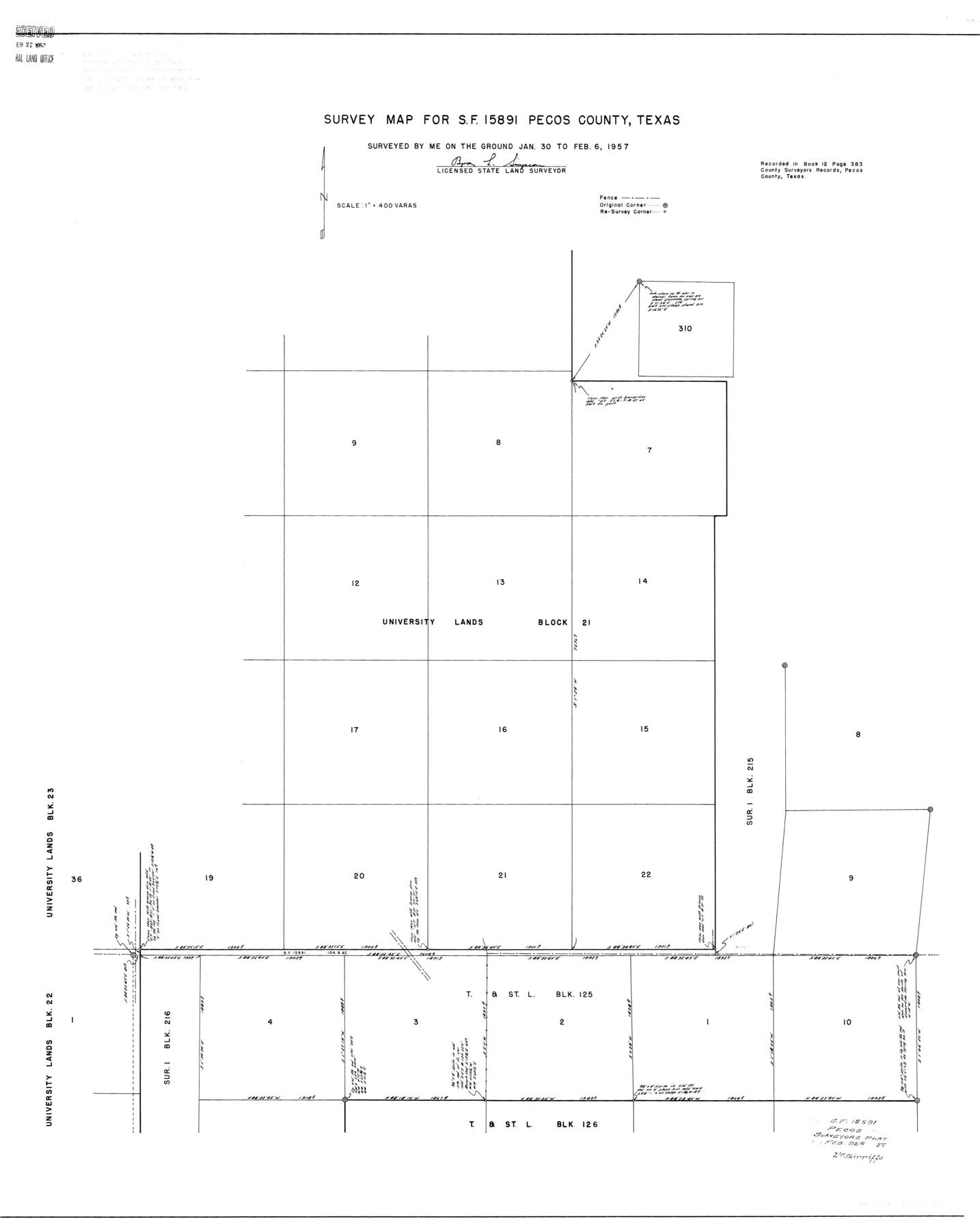
Pecos County Rolled Sketch 146
Survey map for SF-15891, Pecos County, Texas
- 
                          Map/Doc
9734
 - 
                            Collection
General Map Collection
 - 
                            Object Dates
1957/2/26 (File Date)
1957/2/6 (Survey Date)
 - 
                            People and Organizations
Byron L. Simpson (Surveyor/Engineer)
 - 
                            Counties
Pecos
 - 
                            Subjects
Surveying Rolled Sketch
 - 
                            Height x Width
40.8 x 32.5 inches
103.6 x 82.6 cm
 - 
                            Scale
1" = 400 varas
 
Part of: General Map Collection
            Bandera County Boundary File 4b


                                            Print $16.00                    
                                             -                         Digital $50.00                                    
                Bandera County Boundary File 4b
Size 13.0 x 8.1 inches
                                Map/Doc 50281
            
            Brown County Rolled Sketch 2C


                                            Print $20.00                    
                                             -                         Digital $50.00                                    
                Brown County Rolled Sketch 2C
1984
Size 26.7 x 24.6 inches
                                Map/Doc 5352
            
            Brazoria County NRC Article 33.136 Location Key Sheet


                                            Print $20.00                    
                                             -                         Digital $50.00                                    
                Brazoria County NRC Article 33.136 Location Key Sheet
1964
Size 27.0 x 22.0 inches
                                Map/Doc 77008
            
            Buchanan Dam Reservoir Clearing


                                            Print $20.00                    
                                             -                         Digital $50.00                                    
                Buchanan Dam Reservoir Clearing
1935
Size 21.8 x 40.4 inches
                                Map/Doc 60393
            
            Map showing the line of march of the Centre Division, Army of Mexico, under the command of Brigr. Genl. John E. Wool, from San Antonio de Bexar, Texas to Saltillo, Mexico


                                            Print $20.00                    
                                             -                         Digital $50.00                                    
                Map showing the line of march of the Centre Division, Army of Mexico, under the command of Brigr. Genl. John E. Wool, from San Antonio de Bexar, Texas to Saltillo, Mexico
1846
Size 24.5 x 19.5 inches
                                Map/Doc 94074
            
            Van Zandt County Sketch File 29


                                            Print $4.00                    
                                             -                         Digital $50.00                                    
                Van Zandt County Sketch File 29
1859
Size 8.3 x 6.2 inches
                                Map/Doc 39453
            
            Travis County Boundary File 30


                                            Print $4.00                    
                                             -                         Digital $50.00                                    
                Travis County Boundary File 30
Size 10.4 x 8.6 inches
                                Map/Doc 59469
            
            Fort Bend County Working Sketch 15


                                            Print $20.00                    
                                             -                         Digital $50.00                                    
                Fort Bend County Working Sketch 15
1950
Size 22.5 x 14.7 inches
                                Map/Doc 69221
            
            Flight Mission No. DQN-7K, Frame 39, Calhoun County


                                            Print $20.00                    
                                             -                         Digital $50.00                                    
                Flight Mission No. DQN-7K, Frame 39, Calhoun County
1953
Size 19.0 x 22.5 inches
                                Map/Doc 84477
            
            Edwards County Boundary File 1


                                            Print $18.00                    
                                             -                         Digital $50.00                                    
                Edwards County Boundary File 1
Size 15.5 x 5.5 inches
                                Map/Doc 52853
            
            Roberts County Rolled Sketch 3


                                            Print $40.00                    
                                             -                         Digital $50.00                                    
                Roberts County Rolled Sketch 3
Size 38.0 x 49.7 inches
                                Map/Doc 8356
            
            Fannin County Rolled Sketch 18F


                                            Print $2.00                    
                                             -                         Digital $50.00                                    
                Fannin County Rolled Sketch 18F
Size 8.9 x 8.2 inches
                                Map/Doc 5873
            You may also like
            Ward County Working Sketch 10


                                            Print $20.00                    
                                             -                         Digital $50.00                                    
                Ward County Working Sketch 10
1946
Size 29.6 x 15.6 inches
                                Map/Doc 72316
            
            Map of a Part of Lea County, New Mexico


                                            Print $40.00                    
                                             -                         Digital $50.00                                    
                Map of a Part of Lea County, New Mexico
Size 60.5 x 42.0 inches
                                Map/Doc 89910
            
            [W. T. Brewer: M. McDonald, Ralph Gilpin, A. Vanhooser, John Baker, John R. Taylor Surveys]


                                            Print $2.00                    
                                             -                         Digital $50.00                                    
                [W. T. Brewer: M. McDonald, Ralph Gilpin, A. Vanhooser, John Baker, John R. Taylor Surveys]
Size 9.1 x 11.2 inches
                                Map/Doc 90959
            
            Stephens County Working Sketch 23


                                            Print $20.00                    
                                             -                         Digital $50.00                                    
                Stephens County Working Sketch 23
1975
Size 31.0 x 38.8 inches
                                Map/Doc 63966
            
            Navigation Maps of Gulf Intracoastal Waterway, Port Arthur to Brownsville, Texas


                                            Print $4.00                    
                                             -                         Digital $50.00                                    
                Navigation Maps of Gulf Intracoastal Waterway, Port Arthur to Brownsville, Texas
1951
Size 16.7 x 21.2 inches
                                Map/Doc 65449
            
            Smith County Rolled Sketch 6C


                                            Print $20.00                    
                                             -                         Digital $50.00                                    
                Smith County Rolled Sketch 6C
1943
Size 25.7 x 34.4 inches
                                Map/Doc 10701
            
            Dimmit County Sketch File 5


                                            Print $42.00                    
                                             -                         Digital $50.00                                    
                Dimmit County Sketch File 5
1849
Size 8.6 x 8.0 inches
                                Map/Doc 21064
            
            Blanco County Sketch File 35


                                            Print $6.00                    
                                             -                         Digital $50.00                                    
                Blanco County Sketch File 35
1890
Size 6.3 x 7.0 inches
                                Map/Doc 14639
            
            Rockwall County Boundary File 75a


                                            Print $10.00                    
                                             -                         Digital $50.00                                    
                Rockwall County Boundary File 75a
Size 13.0 x 8.2 inches
                                Map/Doc 58481
            
            Limestone County Working Sketch 15


                                            Print $20.00                    
                                             -                         Digital $50.00                                    
                Limestone County Working Sketch 15
1936
Size 14.7 x 16.3 inches
                                Map/Doc 70565
            
            Callahan County Boundary File 1a


                                            Print $4.00                    
                                             -                         Digital $50.00                                    
                Callahan County Boundary File 1a
Size 13.3 x 8.7 inches
                                Map/Doc 51085