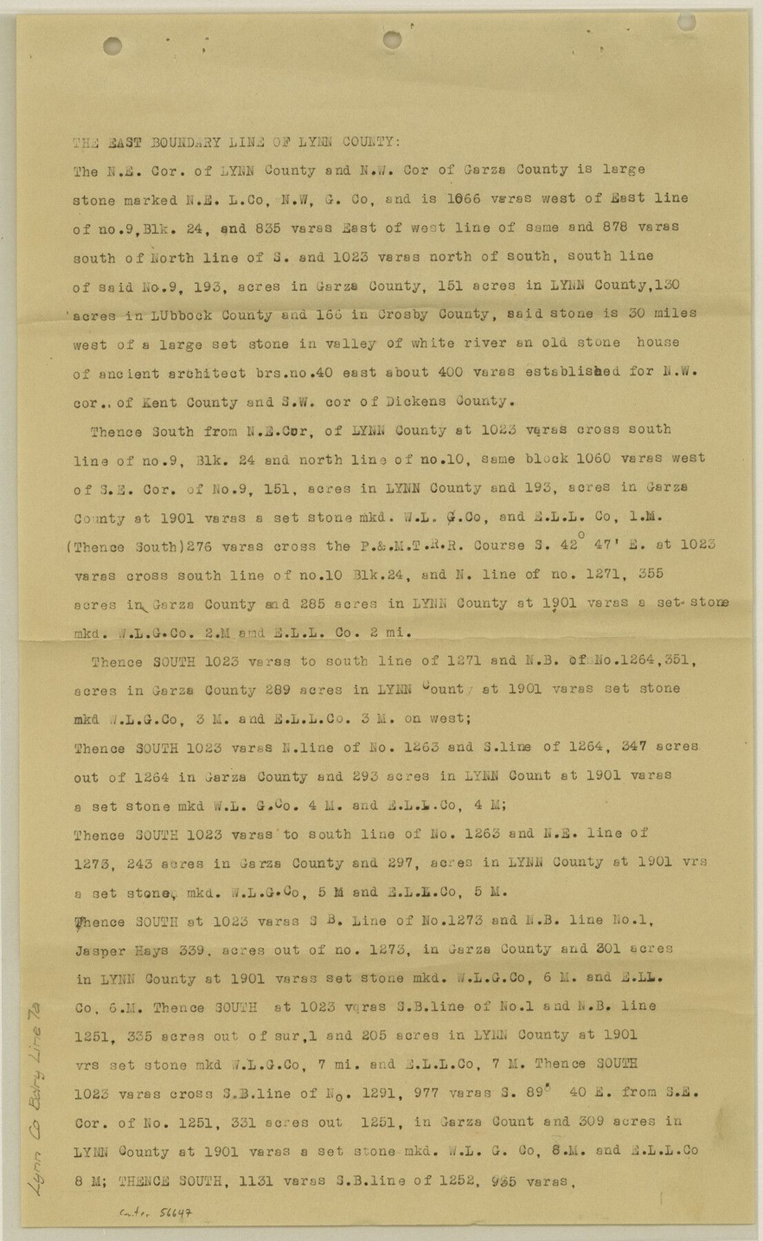
Lynn County Boundary File 7a
[Fieldnotes of the East Boundary line of Lynn Boundary]
-
Map/Doc
56647
-
Collection
General Map Collection
-
Counties
Lynn
-
Subjects
County Boundaries
-
Height x Width
14.3 x 8.8 inches
36.3 x 22.4 cm
Part of: General Map Collection
Supreme Court of the United States, October Term, 1923, No. 15, Original - The State of Oklahoma, Complainant vs. The State of Texas, Defendant, The United States, Intervener; Report of the Boundary Commissioners

Print $20.00
- Digital $50.00
Supreme Court of the United States, October Term, 1923, No. 15, Original - The State of Oklahoma, Complainant vs. The State of Texas, Defendant, The United States, Intervener; Report of the Boundary Commissioners
1923
Size 46.4 x 33.4 inches
Map/Doc 75122
Aransas County Sketch File 20

Print $4.00
- Digital $50.00
Aransas County Sketch File 20
1896
Size 8.2 x 10.2 inches
Map/Doc 13155
Reagan County Working Sketch 14c

Print $20.00
- Digital $50.00
Reagan County Working Sketch 14c
Size 20.8 x 9.4 inches
Map/Doc 71856
Bosque County Working Sketch 27

Print $20.00
- Digital $50.00
Bosque County Working Sketch 27
2006
Size 29.8 x 38.0 inches
Map/Doc 85241
Grayson County Working Sketch 2

Print $20.00
- Digital $50.00
Grayson County Working Sketch 2
1939
Size 27.8 x 40.9 inches
Map/Doc 63241
Map of Bell County

Print $20.00
- Digital $50.00
Map of Bell County
1855
Size 19.2 x 24.4 inches
Map/Doc 829
United States - Gulf Coast Texas - Southern part of Laguna Madre

Print $20.00
- Digital $50.00
United States - Gulf Coast Texas - Southern part of Laguna Madre
1941
Size 26.5 x 18.3 inches
Map/Doc 72955
Val Verde County

Print $20.00
- Digital $50.00
Val Verde County
1944
Size 40.0 x 36.2 inches
Map/Doc 77445
King County Working Sketch 4

Print $20.00
- Digital $50.00
King County Working Sketch 4
1939
Size 42.9 x 25.7 inches
Map/Doc 70168
Kimble County Working Sketch 9

Print $20.00
- Digital $50.00
Kimble County Working Sketch 9
1920
Size 14.3 x 17.3 inches
Map/Doc 70077
Galveston County Rolled Sketch 34A

Print $20.00
- Digital $50.00
Galveston County Rolled Sketch 34A
1978
Size 30.2 x 40.9 inches
Map/Doc 5967
Flight Mission No. DCL-6C, Frame 115, Kenedy County

Print $20.00
- Digital $50.00
Flight Mission No. DCL-6C, Frame 115, Kenedy County
1943
Size 18.5 x 22.4 inches
Map/Doc 85945
You may also like
[Surveys in San Jacinto and Polk Counties]
![69749, [Surveys in San Jacinto and Polk Counties], General Map Collection](https://historictexasmaps.com/wmedia_w700/maps/69749.tif.jpg)
Print $2.00
- Digital $50.00
[Surveys in San Jacinto and Polk Counties]
Size 9.8 x 3.8 inches
Map/Doc 69749
Jasper County Working Sketch 24

Print $40.00
- Digital $50.00
Jasper County Working Sketch 24
1948
Size 44.2 x 54.9 inches
Map/Doc 69651
Glasscock County Rolled Sketch VS

Print $20.00
- Digital $50.00
Glasscock County Rolled Sketch VS
Size 20.6 x 35.3 inches
Map/Doc 6022
La Salle County Rolled Sketch 10

Print $40.00
- Digital $50.00
La Salle County Rolled Sketch 10
1945
Size 48.1 x 33.5 inches
Map/Doc 6573
Kleberg County Rolled Sketch 6

Print $20.00
- Digital $50.00
Kleberg County Rolled Sketch 6
Size 11.1 x 13.0 inches
Map/Doc 9359
Gillespie County

Print $40.00
- Digital $50.00
Gillespie County
1887
Size 38.9 x 49.8 inches
Map/Doc 4956
Terrell County Working Sketch 76

Print $20.00
- Digital $50.00
Terrell County Working Sketch 76
1982
Size 31.8 x 20.1 inches
Map/Doc 69597
Palo Pinto County

Print $20.00
- Digital $50.00
Palo Pinto County
1896
Size 27.2 x 22.1 inches
Map/Doc 3937
Flight Mission No. BRE-5P, Frame 201, Nueces County

Print $20.00
- Digital $50.00
Flight Mission No. BRE-5P, Frame 201, Nueces County
1956
Size 18.5 x 22.6 inches
Map/Doc 86841
Coke County Sketch File 37

Print $6.00
- Digital $50.00
Coke County Sketch File 37
2004
Size 11.0 x 8.5 inches
Map/Doc 82988
Reagan County

Print $40.00
- Digital $50.00
Reagan County
1940
Size 50.5 x 37.7 inches
Map/Doc 78430
Flight Mission No. DAG-18K, Frame 181, Matagorda County

Print $20.00
- Digital $50.00
Flight Mission No. DAG-18K, Frame 181, Matagorda County
1952
Size 15.9 x 15.9 inches
Map/Doc 86373