Aransas County Sketch File 20
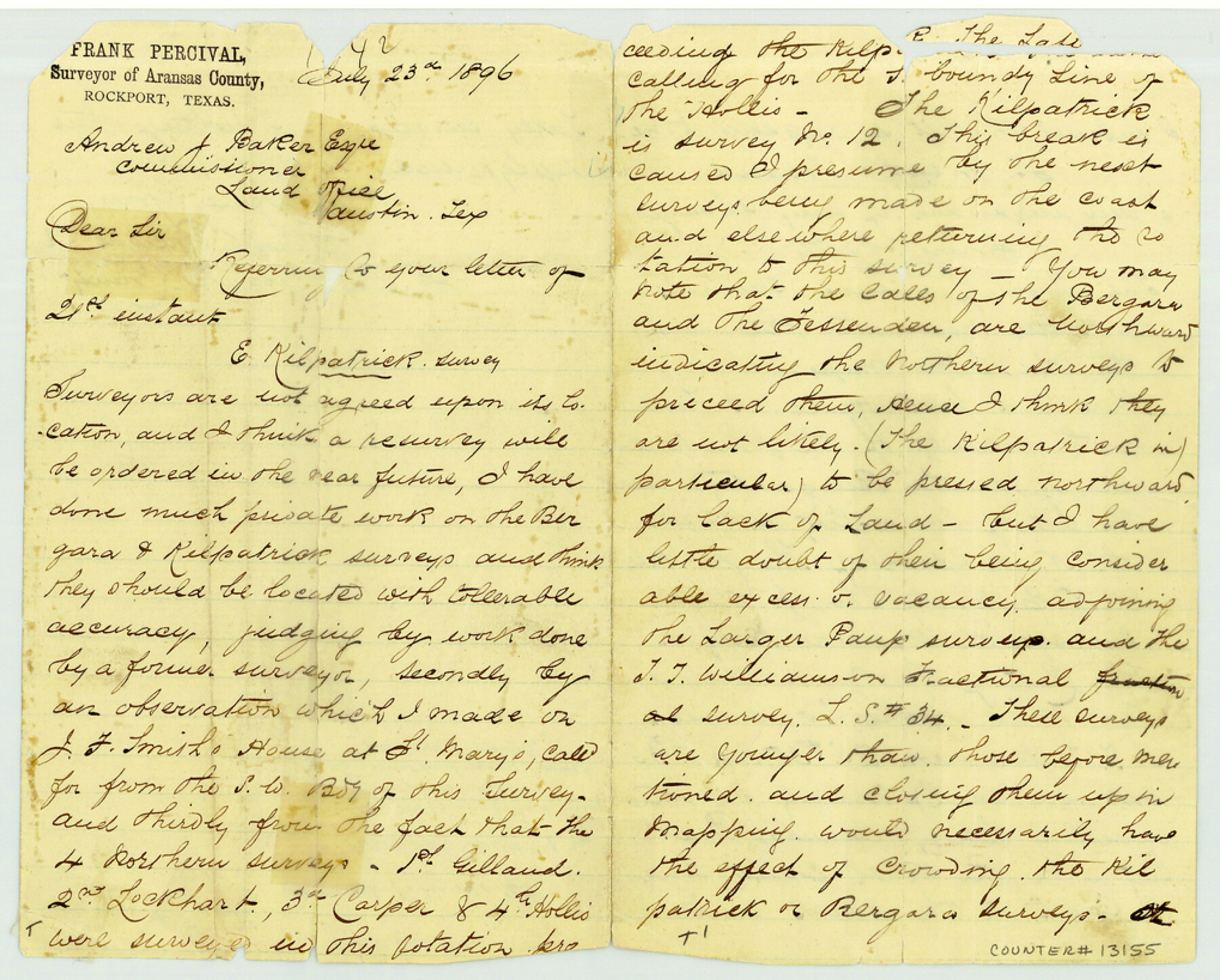
[Surveyor's statement concerning E. Kilpatrick survey and towns in Aransas County]
-
Map/Doc
13155
-
Collection
General Map Collection
-
Object Dates
1896/7/23 (Creation Date)
-
People and Organizations
Frank Percival (Surveyor/Engineer)
-
Counties
Aransas
-
Subjects
Surveying Sketch File
-
Height x Width
8.2 x 10.2 inches
20.8 x 25.9 cm
-
Medium
paper, manuscript
-
Features
St. Joseph's Island
Lamar
Burgantine Creek
Aransas Bay
Rockport
Aransas Pass City
Part of: General Map Collection
Shelby County Sketch File 12

Print $4.00
- Digital $50.00
Shelby County Sketch File 12
Size 8.2 x 10.3 inches
Map/Doc 36619
Throckmorton County Rolled Sketch 6A

Print $20.00
- Digital $50.00
Throckmorton County Rolled Sketch 6A
2004
Size 20.3 x 24.3 inches
Map/Doc 82489
Brewster County Working Sketch 71b

Print $40.00
- Digital $50.00
Brewster County Working Sketch 71b
1961
Size 50.6 x 55.0 inches
Map/Doc 67870
Harris County Sketch File 11

Print $18.00
- Digital $50.00
Harris County Sketch File 11
1895
Size 11.3 x 8.8 inches
Map/Doc 25342
Edwards County Boundary File 1

Print $18.00
- Digital $50.00
Edwards County Boundary File 1
Size 15.5 x 5.5 inches
Map/Doc 52853
Wilson County Working Sketch 7

Print $20.00
- Digital $50.00
Wilson County Working Sketch 7
1965
Size 23.7 x 30.2 inches
Map/Doc 72587
Burleson County Working Sketch 34

Print $20.00
- Digital $50.00
Burleson County Working Sketch 34
1981
Size 20.0 x 12.2 inches
Map/Doc 67753
Padre Island National Seashore

Print $4.00
- Digital $50.00
Padre Island National Seashore
Size 16.0 x 21.8 inches
Map/Doc 60527
Duval County Working Sketch 55

Print $20.00
- Digital $50.00
Duval County Working Sketch 55
1936
Size 25.7 x 21.6 inches
Map/Doc 68779
Gaines County Working Sketch 12

Print $20.00
- Digital $50.00
Gaines County Working Sketch 12
1954
Size 27.1 x 37.0 inches
Map/Doc 69312
Current Miscellaneous File 84

Print $10.00
- Digital $50.00
Current Miscellaneous File 84
1954
Size 11.2 x 8.8 inches
Map/Doc 74231
Chambers County Working Sketch Graphic Index

Print $20.00
- Digital $50.00
Chambers County Working Sketch Graphic Index
1922
Size 39.3 x 47.3 inches
Map/Doc 76491
You may also like
Hardeman County Working Sketch 3

Print $20.00
- Digital $50.00
Hardeman County Working Sketch 3
1919
Size 32.7 x 35.1 inches
Map/Doc 63384
Kimble County Sketch File 3

Print $4.00
- Digital $50.00
Kimble County Sketch File 3
1847
Size 9.1 x 11.5 inches
Map/Doc 28910

Flight Mission No. BRA-16M, Frame 73, Jefferson County

Print $20.00
- Digital $50.00
Flight Mission No. BRA-16M, Frame 73, Jefferson County
1953
Size 18.7 x 22.3 inches
Map/Doc 85690
Kleberg County Rolled Sketch 10-4

Print $20.00
- Digital $50.00
Kleberg County Rolled Sketch 10-4
1951
Size 36.8 x 31.5 inches
Map/Doc 9378
Hardin County Rolled Sketch 15

Print $20.00
- Digital $50.00
Hardin County Rolled Sketch 15
Size 25.5 x 26.6 inches
Map/Doc 6085
Flight Mission No. DQO-1K, Frame 19, Galveston County

Print $20.00
- Digital $50.00
Flight Mission No. DQO-1K, Frame 19, Galveston County
1952
Size 18.9 x 22.6 inches
Map/Doc 84978
Blanco County Rolled Sketch 13

Print $20.00
- Digital $50.00
Blanco County Rolled Sketch 13
Size 14.2 x 28.9 inches
Map/Doc 5149
Plat Town of Swearingen, Cottle Co., Texas

Print $20.00
- Digital $50.00
Plat Town of Swearingen, Cottle Co., Texas
1918
Size 39.8 x 30.6 inches
Map/Doc 513
San Jacinto County Sketch File 1

Print $22.00
San Jacinto County Sketch File 1
1852
Size 7.9 x 12.4 inches
Map/Doc 35694
Hudspeth County Working Sketch 23

Print $40.00
- Digital $50.00
Hudspeth County Working Sketch 23
1967
Size 52.6 x 39.2 inches
Map/Doc 66305
Flight Mission No. DCL-5C, Frame 49, Kenedy County

Print $20.00
- Digital $50.00
Flight Mission No. DCL-5C, Frame 49, Kenedy County
1943
Size 18.5 x 22.3 inches
Map/Doc 85845