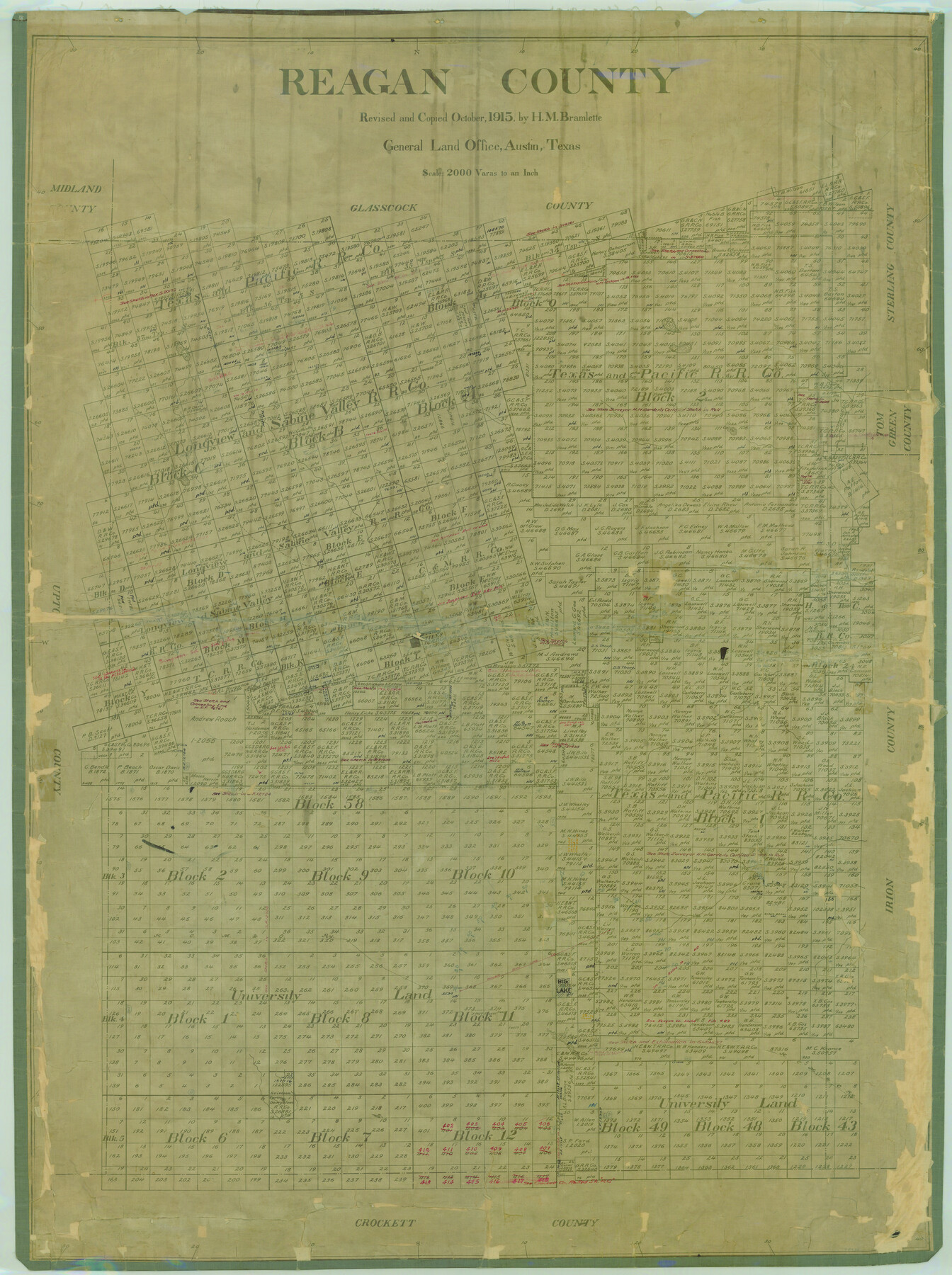
Reagan County
-
Map/Doc
78430
-
Collection
General Map Collection
-
Object Dates
1940 (Creation Date)
-
People and Organizations
Texas General Land Office (Publisher)
H.M. Bramlette (Compiler)
H.M. Bramlette (Draftsman)
-
Counties
Reagan
-
Subjects
County
-
Height x Width
50.5 x 37.7 inches
128.3 x 95.8 cm
-
Comments
Revised and copied in October 1915 by H. M. Bramlette.
Retired 1940. -
Features
Correll Creek
Stiles
Centralia
Big Lake
KCM&O
Grierson Spring
Part of: General Map Collection
Gray County Boundary File 4

Print $34.00
- Digital $50.00
Gray County Boundary File 4
Size 11.4 x 8.9 inches
Map/Doc 53876
Flight Mission No. DIX-5P, Frame 110, Aransas County

Print $20.00
- Digital $50.00
Flight Mission No. DIX-5P, Frame 110, Aransas County
1956
Size 17.7 x 18.3 inches
Map/Doc 83789
Lampasas County Sketch File X

Print $40.00
- Digital $50.00
Lampasas County Sketch File X
1909
Size 13.2 x 17.4 inches
Map/Doc 29386
Hockley County Working Sketch 2

Print $20.00
- Digital $50.00
Hockley County Working Sketch 2
1960
Size 17.8 x 35.7 inches
Map/Doc 66192
Flight Mission No. CRC-2R, Frame 201, Chambers County

Print $20.00
- Digital $50.00
Flight Mission No. CRC-2R, Frame 201, Chambers County
1956
Size 18.5 x 22.3 inches
Map/Doc 84779
Nueces County Rolled Sketch 72

Print $20.00
- Digital $50.00
Nueces County Rolled Sketch 72
1980
Size 18.1 x 25.8 inches
Map/Doc 6930
Coryell County Working Sketch 25

Print $20.00
- Digital $50.00
Coryell County Working Sketch 25
1986
Size 22.2 x 29.4 inches
Map/Doc 68232
Brazoria County Sketch File 45

Print $20.00
- Digital $50.00
Brazoria County Sketch File 45
1980
Size 32.0 x 43.1 inches
Map/Doc 10326
Bee County Working Sketch 34

Print $20.00
- Digital $50.00
Bee County Working Sketch 34
1988
Size 46.3 x 43.6 inches
Map/Doc 67285
Map of Tom Green County

Print $20.00
- Digital $50.00
Map of Tom Green County
1892
Size 44.1 x 47.5 inches
Map/Doc 78389
Fractional Township No. 8 South Range No. 14 East of the Indian Meridian, Indian Territory

Print $20.00
- Digital $50.00
Fractional Township No. 8 South Range No. 14 East of the Indian Meridian, Indian Territory
1896
Size 19.2 x 24.3 inches
Map/Doc 75225
Bell County Sketch File 22

Print $4.00
- Digital $50.00
Bell County Sketch File 22
1872
Size 10.2 x 8.0 inches
Map/Doc 14412
You may also like
Houston County Rolled Sketch 3

Print $57.00
- Digital $50.00
Houston County Rolled Sketch 3
1935
Size 23.5 x 23.4 inches
Map/Doc 6226
Williamson County Working Sketch 13

Print $20.00
- Digital $50.00
Williamson County Working Sketch 13
1980
Size 26.6 x 43.5 inches
Map/Doc 72573
The Judicial District/County of Hamilton. Created, February 2, 1842

Print $20.00
The Judicial District/County of Hamilton. Created, February 2, 1842
2020
Size 14.9 x 21.7 inches
Map/Doc 96329
Flight Mission No. BRA-16M, Frame 178, Jefferson County

Print $20.00
- Digital $50.00
Flight Mission No. BRA-16M, Frame 178, Jefferson County
1953
Size 18.6 x 22.4 inches
Map/Doc 85776
Gordon Addition to Idalou

Print $20.00
- Digital $50.00
Gordon Addition to Idalou
1954
Size 22.6 x 10.8 inches
Map/Doc 92827
Gregg County Rolled Sketch 24

Print $40.00
- Digital $50.00
Gregg County Rolled Sketch 24
Size 40.0 x 49.7 inches
Map/Doc 9075
Orange County Boundary File 1

Print $4.00
- Digital $50.00
Orange County Boundary File 1
Size 9.7 x 6.3 inches
Map/Doc 57773
Henderson County Sketch File 21

Print $20.00
- Digital $50.00
Henderson County Sketch File 21
1941
Size 27.8 x 17.9 inches
Map/Doc 11758

Titus County Working Sketch 1

Print $20.00
- Digital $50.00
Titus County Working Sketch 1
Size 18.2 x 17.3 inches
Map/Doc 69362
Hamilton County Boundary File 5

Print $35.00
- Digital $50.00
Hamilton County Boundary File 5
Size 11.1 x 8.6 inches
Map/Doc 54217
North Half, Harris County, Texas - Ownership Map with Well Data

North Half, Harris County, Texas - Ownership Map with Well Data
1948
Size 121.9 x 44.3 inches
Map/Doc 93206